- The Board has taken six different maps on the road and is sharing with the public.
- Two of the maps (Version3 and V4) are maps the Board members made.
- The other four maps were made by 3rd parties interested in the process.
- AFFER - Alaskans For Fair And Equitable Redistricting
- AFFR - Alaskans for Fair Redistricting
- Doyon Coalition
- Senate Minority Coalition
You can get more information about the 3rd Parties in an earlier post. Or you can look at the maps and see if you can guess which ones lean which way by the results. Then check the link.
The Alaska Landmine published some maps and lists of information on how the maps impacted incumbents. Here's the post for the Board's v3 and v4 maps. Here's the post for the 3rd party maps. The mapping and calculating the impact on incumbents were done by Robert Hockema.
I've taken Hockema's lists and reorganized them in a way that makes it easier for me to see things clearly. We all have different ways of taking in and making sense of information. This works best for me. But I want to thank Hockema for the work he did that lets us all understand how the different maps impact incumbents.
Look at the charts. I have some comments at the bottom, but I want you to raise your own questions and conclusions before you read my thoughts.
[If I make the charts too big, they stretch over into the side column. But these are higher than normal resolution and so you should be able to click on them to enlarge them. If you're sight impaired, let me know and I can send you charts your computer can change to audio.]
1. Board Map v3

2. Board Map v4

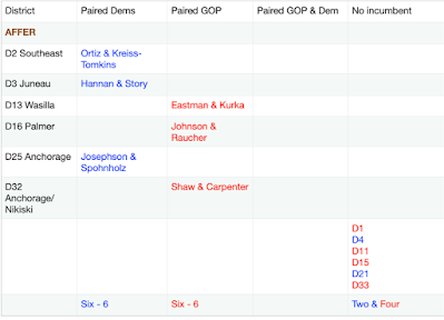
3. AFFER Map
4. AFFR Map

5. Doyon Coalition map

6. Senate Minority Coalition Map

Thoughts
- All the maps pair some Democratic and some Republican incumbents and have districts with no incumbents
- Some have more Democrats paired, others have more Republicans paired
- Four of the six have at least one Democrat paired with a Republican
Some Background
- The Board agreed early on to "not protect incumbents." They never agreed to "not target incumbents." I pointed this out at public testimony and requested they add 'no targeting' to assure the public that the maps were not intentionally aimed at blocking certain incumbents. They haven't done that.
- The Board's executive director has publicly stated on various occasions that the Board's data base does not have political information in it. Thus, to intentionally gerrymander, a Board member must
- already know where incumbents live
- get that information from someone other than fellow Board members or Board staff, OR
- have some other means of going after incumbents
- In Anchorage, the bowl tends to be more Democratic in the north parts and more Republican in the south and hillside parts.
- The current districts tend to go north-south.
- To pair Democrats in Anchorage without knowing exactly where they live, one could switch the north-south orientation of northern districts to east-west and probably catch some incumbents in the same district.
- Before mapping began, Board member Marcum mentioned several times that she'd heard from the public that east-west maps made more sense than north-south maps.
- I also asked, in public testimony, that Board members publicly report if they got mapping advice from people other than Board members or staff, that was NOT given to them in public testimony. Two Board members did publicly state they did not get information from anyone but Board members and staff. The other three have not.
Evaluative Observations
- It's probably difficult to make maps that don't pair any incumbents while meeting the basic criteria for legitimate maps (compactness, contiguity, socio-economic integration, and low deviation) - but not impossible
- One can infer that some maps intentionally paired incumbents, that is they gerrymandered the maps to improve the outcomes in the elections for one party or another. We can't know for sure, but given the leanings of the map makers, and peculiarities in some maps, it seems likely.
- It's my sense that while some Board members and 3rd Party map makers have sincerely used the mapping criteria to try to make fair maps, some, when explaining how and why they made the maps appeared to be using the criteria to justify what appear to be gerrymandering attempts.
No comments:
Post a Comment
Comments will be reviewed, not for content (except ads), but for style. Comments with personal insults, rambling tirades, and significant repetition will be deleted. Ads disguised as comments, unless closely related to the post and of value to readers (my call) will be deleted. Click here to learn to put links in your comment.