Showing posts with label rocks. Show all posts

Saturday, March 05, 2022

Bike Ride To Rocky Beach

 Biked over to Manitou Beach today.  


Downtown Seattle in the distance


Here's that picture again, cropped.  All of a sudden, all the gulls in the area took flight.  

Click on image to enlarge


Monday, July 26, 2021

Saturday Trip To Portage


Our first stop was Bird Point, to get a little beach time.  The weather was cooperative and I found I nice big flat rock to get a short nap in.

xxx


View from my rock.


Some lichen friends were enjoying the sun too on a nearby rock.


And the trail was full of pink clover and white yarrow.


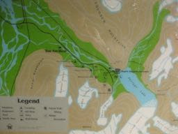
There's a trail that goes along much of the road going to Portage Glacier. Here's the map.


The trail has different kinds of vegetation along the way.


Where we started, we were on the edge of a lake and there was a hanging glacier up on the rocks.  This used to be a key view point before they put the trail in fairly recently.


Here's a quiet stream with a rock garden above it.  The plant world just needs water to get a foothold, even on this vertical rock wall.


And this part of the trail has spruce trees hanging with moss.


A picnic table along the trail.

  
A faster running creek with mossy edges.


While I am a graffiti fan, this is not a place where human efforts add to the beauty.  


The angle of these grass seeds far outshines the paint on the rock.


Then we drove the little bit more to see what Portage Lake looked like that day.  


When we got to Alaska nearly 50 years ago, the glacier extended well into the lake and there were always house sized icebergs floating in the lake.  But it's been quite a few years since the glacier retreated out of the lake and back up into the mountain.  


But there was a 'tiny' iceberg floating on the other side of the lake.  I say tiny because way over there it doesn't look that big.  And compared to the old icebergs we used to see, it's pretty small.  But you can also gauge it against the snow poles on the road in the background.  They're there to help drivers see the road when the snow gets really deep.  I'm guessing they're about 15 feet high and the iceberg appears to be longer than the poles.  


Any day you get out of the house and leave your screens behind for the natural treats of Alaska is a great day, and it was.  

Thursday, September 19, 2019

Beach Walk on Rainy, Cloudy, Rainy, Briefly Sunny Anchorage Day

Had a morning meeting at Kincaid Kaladi Brothers.  Healing Racism in Anchorage is finally ready to come out of hibernation.  (That means the three of us who have been waiting for a time when we were surfacing from deep commitment dives are all now back on the surface and ready to reach our for more members to make this a working organization again.)

Clouds were threatening and so I didn't ride my bike, like yesterday when I got soaked (enjoyably) coming home from another meeting.  And since I was close, I drove to Kincaid Chalet and walked down the path through the gnarly birch trees and and the yellow devils club.  (Not a typical Anchorage landscape.)


Then off the paved path, along a dirt path and finally to a path down to Anchorage's main salt water beach.


Looking south.


Looking north.


Lots of great garden rocks, but no way to get them back to the garden.  


And a good patch of mostly sand


Here's looking out to the lowering tide and the water.  Fire Island is in the distance on the right.  The resolution on this picture is too low to see the windmills on the island, the only sign of humans (other than the footprints) as you walk along here.


Come mid September and one is reminded to get out into the natural wonders all around here beyond the bike trails in town.  This beach is still in town, and I need to overcome my anti-driving bias and get out of town while the weather is still relatively warm and the roads ice-free.  


Friday, July 05, 2019

Argentina’s Bad-Ass Keys And Other Leftovers

We’re back in Mendoza to get a flight this evening to Santiago.  I was showing Alberto the post I did about his hotel, when I noticed that another post talked about all the missing posts.  So I’ll try to share some pics that haven’t made it up here because of time.


Argentina has some serious keys.  These are the ones we had in San Juan for the eclipse, but we had similar ones in Buenos Aires and Mendoza.  Only the hotel in Port Iquazú had a magnetic card to open the door.


Eclipse Light - One thing I learned from the eclipse is that the sun is really, really bright.  I thought I’d take pictures of the landscape at different points during the eclipse.  But it wasn’t until the moon was almost completely blocking the sun that there was much difference.


There were se veral pics that looked like the one above.

Eventually it got a little darker.


Then much darker.  The next ones were dark enough that the exposure was so long that they are blurred.  Just take my word for it, the pictures aren’t worth seeing.  Plus, the camera tries to adjust and make it look lighter than it really was.  At times like this I yearn for my old film Pentax camera.

Then the new brightness as the sun came back out.


It was extremely rocky where we watched the eclipse.  Everywhere was like this pic below.


Finally, mate.  Here’s Carlos, our host in San Juan, drinking his mate while we waited for the eclipse.
I showed some mate cups and talked about this Argentine obsession in an earlier post.

Tuesday, January 29, 2019

Golden Gate Park's Japanese Garden Tells Tales Of What Immigrants Add To US And The Waste Caused By Xenophobia

We ended up at the Japanese Garden after dropping off our grandson at his pre-school.  Our timing was great - as we walked in Mary Ann Provence was about to start a tour of the garden and invited us to join.  There were six of us altogether.

From the garden's website (and covered in Mary Ann's talk):

"Originally created as a “Japanese Village” exhibit for the 1894 California Midwinter International Exposition, the site originally spanned about one acre and showcased a Japanese style garden.  When the fair closed, Japanese landscape architect Makoto Hagiwara and superintendent John McLaren reached a gentleman’s agreement, allowing Mr. Hagiwara to create and maintain a permanent Japanese style garden as a gift for posterity.  He became caretaker of the property, pouring all of his personal wealth, passion, and creative talents into creating a garden of utmost perfection.  Mr. Hagiwara expanded the garden to its current size of approximately 5 acres where he and his family lived for many years until 1942 when they, along with approximately 120,000 Japanese Americans, were forced to evacuate their homes and move into internment camps.  When the war was over, the Hagiwara family was not allowed to return to their home at the tea garden and in subsequent years, many Hagiwara family treasures were removed and new additions were made."
It's all in there - Makoto Hagiwara's great contribution and then his forced evacuation due to xenophobia in 1942.  They even changed the name to Oriental Gardens in WW II and it wasn't until many years later it became the Japanese Garden again.


The rock is the head of a dragon - the hedge winds on up the hill with a rock tail.


Rocks are a key foundation of Japanese gardens. They give it structure, we were told.  Trees and flowers come and go, but rocks stay.  Other aspects - water, walks, fish.  There might have been one or two more.  Oh, yes, bridges.


Most of the paths were gravel, but this stone path, our guide pointed out, was to force you to slow down as you approach the zen meditation garden.


Here the gravel is sculpted to look like ripples in water.  You're supposed to look at it, not walk in it.  But the squirrels, she said, don't follow the rules.

The free tour was one of many offered by San Francisco City Guides.  They do give you the chance to make a donation at the end, but there's no pressure.

Mary Ann was a great guide and she also gave us a great tip - next door at the DeYoung Museum you can go to the top of the 9 story tower to the observation room which is floor to ceiling glass windows all the way around.  That part of the museum is free.  And the view is stunning.  My camera could not in any way capture it, but here's a couple of glimpses.


To the north.


To the northeast.


And here's the tower from in front of the Cal Academy of Science where I checked out the earthquake simulation room Sunday.  If you look closely (or click on the picture to enlarge it) you can see people in the observation room on the top level.

Thursday, April 28, 2016

Savage River Walk - Then Home

[UPDATE May 4:  Little did we know when we were hiking last Wednesday, that we were passing very close to a missing hiker, Michael Purdy, who, it is believed, died Tuesday night from a fall, and wasn't found until Saturday.  I've addressed this in a follow up post here.]

We drove back to Savage River yesterday morning.  It's about 12 miles into the park and as far as you can drive once the buses start - May 20.  There's a 2 mile loop trail on each side of the river connected by a little wooden bridge.  And you slip quickly into the natural world, in a slightly tamed way.  Here's from past the maintained trail looking back where we'd hiked.  Up this point it's an easy stroll, with rocks placed here and there to take the runoff from the hill.  But there are some muddy spots.  Usually in May we've had a fair bit of snow and ice still on the trail.  Not this year.  Just one snowy spot at the end.  We were on the west side (cross the bridge on the road and start from the unpaved parking lot.)  On the other side there were still some significant snow and ice patches.

[I looked for older posts about Savage River, but couldn't find any just focused on that spot, but here's one from May 19, 2007 that is mostly Savage River.]

As always, click on a picture to enlarge and focus.


The motion and sound of the water rushing were a major attraction on this hike.


lichen on a big rock


We didn't see much wildlife yesterday - none of the big ones.  We'd seen caribou, moose, and bears the day before.  But we did see a Ptarmigan along the road (still mostly in its winter white - just the head had turned brown.)  And this ground squirrel along the trail.  We've seen Dall Sheep on this trail, but not this time.  


This was the only blooming flower we saw on this trip - a moss campion I think.  We've never been here so early.  Usually closer to mid May, just before the buses start.  But it was a very warm winter in Alaska and the road has been open to Teklanika for a while now.  We didn't see many birds at all and the plant life was still waiting for spring.  Except this one.


Orange Lichen this time


There are lots of big and interestingly shaped can colored rocks along Savage River.


There are lots of rock outcroppings that I suspect were sculpted by the ice and snow.


There was lots of ice on the river at the beginning of the trail, but at this spot it had all melted and the mud was visible.


We had things to do, but our two days at the park were refreshing.  As we drove south, there were spots where the birch lining the road had leafed out, and the clouds offered a constantly changing tapestry.