That quote in the title comes from the last person to testify in the first batch of afternoon testimony - it's at the bottom. But it makes a lot of sense.
As always, these are notes on the fly. They get a sense of what was said, but leave a lot out because I just can't keep up.
2pm Board back to order.
Anita not here
Sonia Short - (Not yet)
Brian Hoag? -
Torgerson - We're on teleconference. We met at 10am heard from six groups, AFFR, Rights Coalition, AFFER, MOA, Fairbanks, Calista. Some interesting new ideas.
Brian Hoag? Fairbanks - Here on other business and saw I had another opportunity and thought I'd take it. Generally think pretty good job with the plan, my neck of the woods, Fairbanks area balanced fairly well. Happy to see Salcha and Eilson back in the fold. Districts appear to be very well balanced unlike past experiences.
One more thing about district, helpful to maintain the numbering system. Cuts down on the confusion. Thank you. 11 and 12 in particular, back up 7 and 11, Eilson is probably better suited for district 11, and if have to back population out, can look in NNW of Dis. 11. ONly other thing, I know there is a reason for everything, but D9, section of College Road, then dips down to slough and then back to College Road, natural thing would be to continue along College Road. Balance thing. Maybe on the west side come off sooner. On east side dips down to the slough. Maybe that's something we can look at. I know there's a reason for everything. thank you for your service.
Mike Symanszki: Live in Big Lake. Honor of being in Legislature several times, very compact south Anchorage district. Thought once to run for the Senate and ended up in the donut district from S Anchorage to Whittier, Cordova, Valdez, McKinley and almost got Tyonek. So thought I'd stop by and share my perspective. Lots has happened since I was in he legislature. Constitutional amendment now requires single member Senate districts. I commend all of you in this process cranking out plan in 90 days. Message: Living in Big Lake, as former Rep. the challenges of meandering districts just doesn't work. Separateion, ability to represent is just absurd. More compact, dense, closer relationships you can have in House or Senate districts the better. I couldn't do it. Oil interests fighting with Fishing, pro and anti development together.
In Valley where I am now. Numbers about 5.7 house districts - 3.5/2.5 Senate districts - shows how I've done my homework. Now, in Big Lake, we have Senator who lives in Birchwood. Don't get a lot of attention when asking for representation. Shouldn't put these tail sections of districts which are hard for reps to represent. Anchorage and Fairbanks will be compact. SE - have islands - difficult. Like to see the Valley particularly held to compact unit. That's all I have to say.
Torgerson -
Mariam Landow - last time held testimony here, some testified they liked AFFER plan because it follows Community Council plans, but while true in South Anchorage, I have map here to show. AFFER's original map superimposed over Community Council lines. This morning's map is slightly different, but not that much. The second map is identical to that put forward by the Muncipality this morning.
What AFFER said about Community Councils isn't true - they don't follow CC lines. Put CC's into up to four districts. Looking at Senate pairings, most CC are not united. Randy Ruedrich says his plan matches CC's. He criticized your plan for leaping across the Seward Highway to split a community council. AFFER's plan does exactly the same plan. I think the board shouldn't consider either of the plans - AFFER and MOA's - using Ruedrich's own plan. Urge you to do one better to keep Community Councils intact. Thank you.
John Olson -AUDIO - I'm against modifying the language. RE is known as demon god of the underwolrd took me to court. I don't know why you are modifying the language. Anyone could change this to anything they want to change it to. There's nothing there. That's it.
John Ford - Petersburg - my thing is, so called redistrict is WHY? Create more revenue, steal more money out of people's pocket books? Alaska has no contracts to go by. Engage theft of Petersburg theft of property, I'm a first hand witness. High officials destroying maps of land owners and committing array of crimes for theft of property and no one ever does anything about it. Do as you wish baffle the people with a maze of BS. That's all I have to say cause that's what this is.
Torgerson: Back to Anchorage.
Jerrod McCort? - Thanks for opportunity to comment. D31 does jump slightly over the highway, but that's a business district. Oceanview where I live .. Options 1 and 2 flawed. Maps ....can't hear. Doesn't actually go to Beachcomber drive. Goes behind my house. Rely on creek that is little more than a drainage ditche. and ignore more significant landmarks - Campbell and Chester Creek. AFFER map improved since last testified. 29 doesn't go into Sandlake. I support AFFER 30 from Campbell Lake. All in Assembly district. Also AFFER 31. Half of Huffman/O"malley are in district 31. AFFER maps follows Constitutional guidelines. Thank you for your time.
April Ferguson - I have with me Natalie Landreth. VP of BB Native Corporation. Thank you all for your public service. I hope like you we won't be here in July. Focus on Boards 2 option. Both 1 and 2 purport to have 4-2-2-1 plan. But current plan, based on ?? not only has the population changed. ABility to elect is the standard to be used. Now called effective district and influence district is gone. The AG does not rely on any fixed demographic percentage . . . often includes election history, patterns, crossover patterns 7471 guidelines of Federal REgister. Board seems to base their plans on fixed 35% and 50% criteria. Have not done any anaysis yet. I understand that VRA expert won't have analysis done til about May 10th. And she is not sure 35 and 50% would still be valid. And testimony won't be taken on her analysis.
Sen. C at 39.2% - 37 only has 46% - why considered a majority district.
1. What is actual floor for Native district
2. Public Comment period open several days after her report made public.
Matt Ganley -representing Bering Strait Sea Corp. Concerned with D39 and severe mutations. Once all had a nice compact, contiguious 39, easy to define socio-economic unit. Like your 1 or 2. It fits the ideal the vra is looking for. Shares the same futures economically of its people. Like what it looks like in Options 1 and 2. We met with AFFR and they took to heart what we discussed. Much better picture now for residents of the region. AFFR is ideal for 39. If can't be achieved, another possible not completely acceptable. 5-0 plan. Bush Caucus modified 5-1-2-1 plan. Boundaries much the same Not ideal for us stretches to Canadian border. But what it does avoid is a significant block from Fairbanks area into D39. Thank you for your public service and putting up with us.
Torgerson: You aren't in favor district from Bering Sea to Canadian Border.
Matt: Not, but would prefer this one.
Matsu LIO
Burt Cottle, Wasilla Dept. Administrator. Like to consider separating Wasilla and Palmer and not put us int he same Sen district would help. Then both Senators could work together and not be pitted against each other.
Juneau LIO
Jaeleen
Sitka LIO
Lorainne Stedman - Southeast concerns. Hearings in Sitka last week - from 1-3, didn't overlap lunch hour or after work. Hope you get comments by email. Not in favor of eiether paln.
Doesn't reflect ...
Private plan, like those that keep SE intact. 4 and 2 best for SE with outflow of population. Splitting Sitka isn't good. Basically islands with no road connections. Native influence considerations need to be addressed. with disollution of Ds.5, should be able to work it out. Very out of sync, .... recommend looking at private plans that keep SE intact, moving SE into interior isn't good.
Glenallen LIO
Wilson Dustin I'm from Sustichina? ?? Tribal Council, Option 2 may be modified to be acceptable. The AFFR proposed plan we favor. Chistschina??
Ketchkan? ?? - We simply don't understand how you can take two communities - always a big part of Ketchikan into separate district - island that has our airport in separate district. Look at Rights plan and AFFR, both do good job of SE. Also four contiguous house seats and senate seats in SE. ONly constitutional way to do it. Either AFFR or Rights plan, take adequate account of minority voting issues we have to consider.
Haines
Kathleen Menke? I support the plan presented by Rights Coalition, either alternative 1 or 2 I would support. For SE Alt 1 is better because Yakutat isn't included. But Alt 2 addresses needs of people across the state, like Bethel and Kenai, if it works best for the rest of thestate moving Yakutat is accepatble. I think the Sen pairings are so sensible. Put people together in common socio-econ interests. IN SE in particular. We're losing a district so those four districts need to be HD1-4 and Sen Aand B - anything less would be totally unfair to SE. Compact, contiguous districts int he best interest for all Alaskans.
Matsu
Elizabeth Gray - Hello. Asst. B Manger for Matsu Borrough. Both plans have problems but Option 2 - doesn't go to Delta Junction. Option 1 carves up Matsu and doesn't meet Constitutiona req. Dis12 is up and out for sole reason to join fairbanks for Senate connection. Option 1 is worst. District A in 2 is better. At least share history of coastal communities. DA in 1... Option 2 still has deficiency. 12 people on Western Parks Hwy - line should be moved east and let people be in House D 13 back into borough. Other ties shared by 13 residents - in community councils.
There are needs for large districts, but we should keep borough together. Carefully consider constitutions requirements, reject option 1, and pick one that works. We should have 5 representatives. We'll be submitting proposal for revision. thank you for your time and dedication. Hard job and we appreciate your service.
Unalakleet -
Frances Degnan - live in 39, I believe we need to stay with socio-economic status of district, as compact and contiguous as you can make it. Shouldn't cross from bering sea to CAnadian Border for one district. We are Coastal and Riverine.
Anchorage;
Vicki Russel - Good Afternoon. thank you. President of Alaska Women for political Action. Non-partisan dedicated to election pro equal rights and pro women. At our last meeting we supporte AFFR plan
1. Good compromise undr Alaska's constitutional requirements - recognize you worked hard. AFFR does a good job solving the problems. Right number of Native districts to comply with VRA.
2. In urban areas, should minimize changes - not pair incumbents. We feel AFFR has done it well.
Thank you for this chance to speak and your service on the board.
Juneau:
Jaelene Araujo - VP Sealaska, originally from Angoon. Alaska Native. Express my appreciation for being mindful and trying to avoid retrogression. We've lost population in SE and is difficult. We do have important points
1. Try not to have incumbent pairings or at least avoid having us lose both native incumbents.
2. continue native influence in SE - present 2 Native leaders representatives
Comment board for working within VRA standards but see problems
1. both AK incumbents would have to face non-native incumbents from urban areas
2. A district constitutional problems because of contiguity
Prefer alternative plans because native incumbents won't face challenge
Different plans from Bush Caucus, AFFER, problems with each of them
Top choice
1. Board plan, but alternate
2. Bush Alt 5-1 both reps unopposed, but no Native influence int hat plan
3. AFFER plan, possible to not have both Native people opposed. But splitting Sitka, Stedman could end up in either because he has two homes.
k
Anchorage
Daryl Nelson - thank you for allowing us to testify. I believe owner of successful advocy services focuses on issues not party lines. Also believe that Chugiak and ER should be together Now, Chugiak is part of Matsu. We need to focus on, go by borders of municipality. If you split the two, very hard to work on campaigns, heard to talk to people. I've worked on many campaigns and it's really hard in wheel chair to go house to house. If you include ER with Chugiak, better yet. If only two options. I prefer #2. Peters Creek and N. Peters Creek part of Matsu
I'm Daryl's Mom - Bonnie Nelson - Daryl's made trips to Lower 48 to teach legislators about disability issues. I ran for State House last time. Really hard in the area. Good experience. He was my campaign mangers. Hard to deal with issues in ER, Chugiak, and Palmer. Can't represent people in good way.
Wasilla - Mayor. Mr. Upright
I know it's a tough job. Weighin in. Tough options. From Senate district side, don't see it working for benefit of Wasilla. Connecting us to Palmer SEn. not helpful. Also connecting us to West and north. They have a different development mindset - basically none at all. Assist us with a SEn. dedicated to Wasilla area. Thank you for your time.
We'll do some off net.
Daniel - Wasilla Need for borough in need our five seats. Your plans cut us up. We need five dedicated house seats. Look carefully at Rights plan - gives us what we need and deserve.
Patricia Higgins in Anchorage - Live in 30 now in Anchorage. I wear many hats, just as citizen now. Member of my community Council. At our meeting last week. Looked at Census map. These numbers come out good. Should be able to do Anchorage bowl without going outside. But shocked when I saw the map. Break boundaries where toally not necesary. We need process and lines that are fair. District 30 now, we'd have five house and senators. Acnhorage boundaries all over the place. Across the Seward Hwy. Neighborhoods together don't have common characteristics. Need to go back. Keeps neighborhoods together. Certainly keep boroughs and cities together.
David Metheny - Anchroage 24. Would like to see a map repsectiful of local govt. boundaries, particularly borough. Doesn't split SEn district without contiguous house districts. Map that didn't put half Muldoon and ER together. Matsu get five full disticts like they deserve. I'd like to stay in District 24. I like my representatives. If anyone is going to fire my reps, it should be the voter and not the board.
Friday, May 06, 2011
Calista Stresses Cultural Heritage - Supports AFFER Plan
Last presentation - Calista Corporation
Martha Davis and Andrew Guy
Guy: Thanks for letting us speak. Yupik people in this area face many challenges in YK Delta. Described as still living in 3rd world conditions - no running water. How important reapportionment is to us. Boundaries should not be drawn to damage rural house districts. We understand that DOJ do not distinguish between different cultures. Do not understand our need to preserver our culture and language. This board cannot ignore DOJ rules. Thus you must find boundaries that will meet DOJ mandates. You have heard AFFER plan. We support this plan as the districts are compact. However, AFFER if there is no acknowledgment of??? if DOJ says there must be nine districts, then we support AFFER plan. 4 majority house 10-7, two min 2/6 One challenge is that urban Fairbanks district has five and one must be paired in non-contiguous senate district.
Therefore we offer a third option. Another 9 native district. All house districts paired in contiguous matter. Bush caucus put together.
Restores to D7
Tyonek and? into 6.
You can see great care taken to honor native boundaries.
9 Bering Straits and most of Doyon
?
6 BB and Aleut region
5 Coastal Kodiak and Chugiak
?
1-4 SeaAlaska Region
Most of the Native Corps are in single districts.
Only Anchorage divided into many districts.
Stand in place of local boundaries.
Necessary to extend beyond in some instances - long east west distances, but only if consolidate villages into one voice.....
Honor ANCSA boundaries
Compactness
Contiguity
Socio-Economic
Cultural
If AFFER doesn't meet DOJ approval, then we offer this plan.
11:20
White: Southeast - it would mean does not pair Native? District 4 all within the borough of Juneau? Yes. Borough boundary of Juneau only broken once. That's where 2 comes in.
Davis: Blow up of Juneau shows in clear detail. ....
Thank you Mr. Guy.
11:23
Torg. We'll stand at recess until 2pm
Fairbanks Mayor Presents Alternative Fairbanks Plan
[The Mayor presented via audio.]
10:50 Mayor Luke Hopkins, and Chris ???
Mayor: I hope you have our maps printed before you.
Torg: yes we do
Mayor: Don't need full 1/2 hours. Sent letter in April, some of those conditions and comments are no longer relevant for this presentation. But submitted Fairbanks NSB - similar to Rights Coalition plan. Tweaking within NSB boundaries and what I want to discuss today.
 Issue wherever possible Muni's excess population should go into one group. All the parts have problems with the excess going off to other groups with out the SEconomic connections to our borough. Every other piece wants part of us. But tied to different Socio-economic groups. Different cultures, different economic basis, no urban concerns, different lifestyles, and other issues.
Our census population is how I want to pull the concerns of our residents back within our burough. Half districts - 8,000 Fairbanks citizens grouped with off road rural communities with no se similarities and off-road, is of concern to me.
Geo and road boundaries and cohesive neighborhoods, reducing to possible neighbors along ??? streets. Not sure what final plan you have, can't see from here. Our map, as we go along Chena Hotsprings road, separates t2o rivers area into 2 separate districts, our plans puts them back together and makes more sense of Geo boundaries - pipeline, major roads, sloughs, meeting requirements of deviations, but dist 6-10 wholly in borrough, and 5 matches with road district that includes NPole, agricultural areas along Eilson, Military and road access all the way to Valdez.
Looking at population changes that Rights group post, we offer different plan - can have all within Borough except for the 8,000 that is tied economically/work with highway to Valdez.
Looking at other plans we heard and viewd - things like school districts, utlities etc. all point to issues FNSB that we've taken ????? I know that in boradest sense, concluding here, our ecoomic consideration not similar to Ketchikan or Holy Cross when I look at our population. Also don't mix well with Matsu which has its connection to anchorage economy. We have cohesive grouping within its boundaries. When have to divide up a borough and must take it out of borough, excess should go to brouping with similar characteristics. Every plan excepts Rights plan has paired Fairbanks residents who drive ten miles to work on paved roads, running water, shopping centers, do not match.
We hope you consider this carefully in your next plan. Thank you
11:03
Chris: Our plan does not take in any other boroughs, no Matsu, no parts of Denali, trying to stay within our boundaries and serve our citizens.
Torg: Questions. Legal counsel has questions.
White: I'm looking at the maps. In our grouping. Map3. The broadest overview. You combined. Coming up from South Valdez district - you went left to fill out the district. Why not go right? Why combine Eilson?
Mayor? Criteria for that area. I don't believe it addresses the concentrated population we have in the borough. Not a lot of agriculture, military or pipeline employment in the right. That's the reason, if I understand question and map.
White: We had testimony that said keep Eilson with Fairbanks not Valdez.
Mayor: that's when we were looking at some of the plans. Finally had Rights plan - that testimony to now, when we do it, not the way the Rights plan did it, this is the best for people who have similarities.
Chris: going to right, just bombing ranges. Voting precincts would have huge disconect. That area is nothing. Had gone off to left side and combined it with Salcha south, huge discontinuous area.
White: Can you tell us how much of North Pole you put into 5?
Mayor: Yes between 5 and 6 along pipeline route. Both are tied in same Senate district. We have different house districts. Took from Coalition plan. Moved approximately 2 blocks addressed two rivers along hot springs road. Within 6 the entire NP city - took the entire zip code.
White: Senate pairings?
Mayor: 5&6 7&8, 9&10
White: Deviation in 5 3.??% over. Why so high?
Mayor: Within the allowable. When tried to move that half district around, felt being within the acceptable deviations, it matched the socio-economic aspects of the borough. There could be some tweakings of 5 in the Rights plan. Portion around Tok might rduce some of that. Our balance for our proposal, thought you'd find it acceptable.
White: Thank you very much, we appreciate all the work you did.
11:10
AFFER Presents Revised Plan
 |
| Mayfield (l) and Ruedrich |
[AFFER is Alaskans for Fair and Equitable Redistricting - apparently headed by Republican Party chair Randy Ruedrich.]
Randy Ruedrich with AFFER, Thank you for your incredible work - reports from people all over the state saying you'd been there.
We want to update our basic plan. David Mayberry will do that.
We've revised our map after hearing public testimony. Complies with board principles and respect Native and cultural differences. Cleaned up boundaries to match drainages... and improved some district compactness. Focus on VRA, which requires us to protect as best we can rights of Natives, converted one district into Majority district - 37 from influence to majority. Minority District 2 reinforced and is at 35.65% and % of all Natives in 2 is 36.??%
Dist. 37 is blend of Athabascan, Aleut villages? others stay more homogeneous.
Adding non-Native residence in D6 reduces ???
Specifically SE map
Districts 1-4 - Overall objective to protect Native VRA district in SE. Reassigned Cordova, D 5 is 6000 short and basis for D2, Several camps removed to, and from D5, got new 2 with 37.8%, we're calling it the fishhook district, heir to ice worm district. Adds Juneau airport and Switzer district.
Dis 3 starts at 3400 under, adding Gustavus, Tanakee Springs, .... gets to 2.2% deviation.
[Can't keep up with all the details.]
For comparison, 1972 map used over 800 miles of water to connect Kodiak and Adak so feel our water connections ok. SEn A pairs 1 and 2 has AK native% of 28.19%
Interior Dis. 5-10
Reduce District 5 AKMinority to 2?% = Eilson AFB available for NSB district.
6-10 not changed from original AFFER map 3/31.
Matsu
11-16 - they should get five districts Uses Knik bridge to Link S. Matsu and Anchorage.
Core= Palmer, Big Lake, Houston have been adjusted based on feedback
New 15 - Wasilla - Houston extends down the Knik Bay road to Prt Mc.
Dist. 11 reaches right size by dropping Eilson AFB on N.
Anchorage
Restores ER community to single district. S Anchorage linkage gone based on complaints.
Campbell, Chester and Fish creeks used as Constitution. Anchorage used for Assembly districts. EAFB - added.
Adjusted to conform to CC and Assembly. Segment of 29 rolled into D 27 - better conformance to fish creek.
29 Taku/Campbell has been simplified. Irregular boundaries south of Dimond Mall unresolved.
D30 best for matching natural boundaries - n campbell lake, N. assembly boundary, Western is Seward Highway, and match D 32
Changed 32 - relatively compact - Girdwood to Huffman Road and Hillside. All remote areas reassigned to more compact options.
Kenai Map - Populations balanced by adding small neighborhood from 33 into 34 and moving 33/35 boundaries northward using local input

Rural and Western map -
D 40 - -4.9% 79??% changed up to 88%
others reassigned to 38 - N 86.5%
37 has 5.15% deviation ????? -4.?% deviation
AFFER looks forward to answering any questions.
Ruederich: Aerial photography of Anchorage. Most CC splits we made captured majority of population. If look at Campbell Park CC - most is in South, tiny part here - we added this small piece back side of road to Basher to this little area south of Tudor to 95% of the population added to Scenic Park??
Precinct here has core of NE CC - below the rest of NE with Scenic Park and Basher.
Our basic premise early on that a solid 7 district map from VRA expert. So we came up with plan for our group that covers a nine VRA districts. One new Senate influence by going in and taking the d5, coming out of SE - different by adding Copper River Ahtna people and combing them with district to only Minority influence gives us 35.3 ANatives in thsi combined Kodiak and Aleutian district. The people we used before are available to reconstruct the other three historical minority districts. S1/2 of 39, added Denali Borough, southern NSBorogh Salcha precint - creates two majority seats and most importantly a Sen majority. 78% in 7 and combined sen seat of 7 and 8 = 69%. Goes ito NSB to Canadian border - that district when combined with 10 has Sen 68.1%. We have created a paired Maj/Minority seate, ?????? three senate seats and 4 majority/minority house seats, and minority influence district and the d2 David talked about earlier.
It's a nine VRA seats - only significant change, taken population out of Western Matsu and given to Eastern Matsu. Awful fast sorry.
Torg: We don't have copies. You must have a non-contiguous Senate seat.
Ruedrich: Minor House seat in SE not paired for VRA {Voting Rights Act] sen. seat. Took a 28% seat and paired it with a majority seat to get majority influence Sen. seat. Only complication is to reach over Salcha. Went around N and S sides of Fairbanks.
McConnochie: Which pairings
Ruedrich:
1. North - 2 house seats and sen majo
2. Pair of Yupik - both majority house and sen = 6
3. Min influence in D6 - the other influence is 2 in SE.
4. Pairing of 5 and 6 gets Min Senate
Ten districts to get the nine entities.
White: [Missed this looking for an outlet for the computer] How Native reps paired?
Ruedrich: Reason Wrangell is VR district because it has significant Native population.
Kookesh would be in Sen A by himself
White: For all groups - have you provide your GIS shape?? files to us.
Torgerson: Next Fairbanks NS Borough. From Fairbanks. Just a moment.
10:50am
City of Anchorage - Community Councils the Basis of Our Government
 |
| Baker, Ossiander, Gruenstein |
Ossiander: We've heard a lot about your plan. I've put together a committee of people from where the most comments came from and common understanding. Best approach constitutional guidelines - physical, geographic marks, respect our neighborhoods. Our charter says city should be in community councils and these are good voices for neighborhoods. Although compact, fairly diverse.
Color coding is our community councils - these should be recognized. Talked about clerk about her concerns about split precincts. Found real commonality of interest between assembly and mayors office.

Three most problematic parts of your draft plan.
1. Southern Boundary of Anchorage - Lower hillside and Kenai. Ours stops at Portage - southern boundary of Muni.
2. Lots of discussion about NE. Growing quickly, High density housing. NE CC talked about you for 90 minutes. Not happy. Draft plan had NE cc split into 4 legislative districts. We tried to keep it intact. Best way to combine with Elmendorf.
Also talked with ER folks. I was here before as individual. Now speaking as Assembly member. We believe natural connection with ER going north - common on a lot of issues. We believe the give, if it comes, should be at that part of town.
We are arguing for our neighborhoods, boundaries.
Gruenstein: Anchorage has 119 district split among Assembly districts. I've been clerk for 8 years. We have these split precincts hard for voters and everyone to understand. We made a charter amended on 2008 to have our process after state is done. Before had to do it before state done.
Baker: I think as Debbie mentioned, current plans, go to the very heart of our charter and governance. Dire concern, it does not accomplish goals of our charter. Made sincere attempt to go back to our charter so boundaries coincide by creeks, major highways, and particularly community councils - and your plan doesn't accomplish that. We're not here to weigh in about the rest of the state, but what best represents the best for Anchorage. On your far right, not only best for CC, the basis of our government, and also variation by district and it's less than one percent which goes to the VRA. Tried to make your life easier, but also a plan that truly goes to what our govt. is all about - creeks, highways, CCs, and precincts. Hope you'll give consideration.
Torgerson: You mentioned Chugiak to Matsu - Northern Boundaries.
Ossiander: No, that's the one that goes beyond the Borough.
Holm: Maintained earlier tired to maintain community councils, but I see a number of cases were the cc are also incorporated in a number of house districts. Say NE corner - you have 4 house districts in that one blue area. That was the complaint when you started. It seems that you left it.
Ossiander: We face the same problems you did. No perfect solution. Looked at historic neighborhoods. Impossible to achieve in perfect sense. Not exactly alligned to our goal, But much closer than yours.
Torgerson: We did not use Community Councils in ours. And we felt the Muldoon pain.
You divided the bases?
Baker: We really looked at it on a total basis. Those we could closely align and not divide, others we came as close as we could. In S Anchorage, Taku/Campbell - they usually have more elected officials than citizens - six house districts - six reps and 2 senators and 4 assembly members and sometimes 12 citizens as well. This really condenses this more.
Torgerson: Thank you for all the work
Next: Alaskans For Fair and Equitable Redistricting. Brief at ease.
10:17am
Rights Coalition Presents Their Proposal
Jake Metcalf, Deborah Williams, and Leonard Lausen. Thank you for your work. I spent two weeks earlier this month traveling around the state for my employer so I understand what you've been going through.
Our plans, yes 2, meet all the Federal and state requirements. All equal in size.
Plans - chart showing that it meets all the requirements.
Supreme Court past ruling: "where possible, all Municipality's excess population should go to one other district in order to maximize effective representation of the excess group."
REspecting Distric Boundaries - Matsu 5
Respecting City Boundaries - Fairbanks 1 district, all cities in tact
Juneau - SE deserves 4 entire house districts, Matsu
This is going very fast - taking pictures of the slides.
Matsu has five districts that they deserve
Fairbanks - Districts 6 78 9 10
Valdez/Richardson Hwy
Anchorage - Districts 16-31 - No political gerrymandering
Community names match districts
Kenai
HD 39 - Nome/Upper Yukon - at least one district needs to be huge. Cuirently District 6, this is the new big one, but more compact than 6
SE HD 1,2,3 same in both alternatives - heard NPR story about your meeting in Petersburg and complaints about splitting them up. OUrs leaves them intact. Districts compact.
Differences in Alternatives:
HD 4 different - with and without Yakutat
HD35
Bethel 36, Dillingham (37), Kodiak/Cordova(38)
Rights plans meets all the principles and requirements.
Urge the burough to adopt one of these too. We also support AFFR's request for extension of time for comments to discuss VRA analysis. Thank you
White: Jake, p. 10-11 - population data, Native+1 I understand. That's total population?
Lausen: Yes
White: Numbers on first alternative a little small, so I'm ... laughter
???: Damn small
White: I understand Natives unanimously did not like your plan?
Lausen: Not, ...I do not recall any negative remarks made about the plan.
Williams: Our plan, with respect to 39, many of the Athabascan villages would be associated with Majority/minority district. Alt. 2 in particular, we have a compact District 36, postiive feedback, no general or specific negative comment
Lause: Dillingham BB wanted more watershed. Alt 2 able to provide that. REsponed to feedback.
Williams: What the board sees, Alt 2 presents a 37 that is contguous by water an air. Land connection separated by keeping entire lake burough intact. Wanted to present intact for Lake Burough. Make argument that district is contiguous since transportation there is all by air and boat. Alt there is a land connection, Alt 2, not.
White; 35 runs all the way to Sand Point, 37 connected ..
Lausen: 37 connected Bristol Bay and Aleutian Burough. Connected by water, but if board doesn't like that, offer it combined by land.
Williams: Southern of 35 is S. Cook Inlet Native communities.
White: thank you.
Torg: I'm sure we'll have more.
Lausen: We believe they're good, but we have contingency plans to get numbers higher if voting rights act expert requires higher numbers.
Williams: We hope that VRA expert considers in Bristol Bay considers that Census did not ask about citizenship,because i the canneries there are considerable non-citizens.
White: Your plan does break Kenai Borough in two places.
Williams: Kenai had to be broken twice for ???Voting Rights?
Lausen: Kenai could be intact, depending on the VRA expert's number requirements.
Torg: thank you. We'll be in touch. Next MOA.
9:58am At ease
I'll try to get visuals up soon, but things are moving right along.
AFFR Presents Plan They Say Meets All Requirements
 |
| Carl Marrs and Joe McKinnon |
AFFR - Alaskans for Fair Redistricting is presenting their plan.
4 Native Majority House Districts
2 Native Minority House
2Narive Minority Senate
Pairs H35 - Kodiak with Aleutians
Included everyone identified as Native and part Native as DOJ will.
Preserves much of the Board's proposals for rural Alaska but eliminates non-contiguous pairings.
Interior highway and Bethel is also like Boards.
YK Delta to Denali Borough - has vulnerability in ours and the board's draft plan. But some commonalities. SE integration not as strong as other districts, but should be ok for VRA.
H35 includes Kodiak, and several others - SEldovia
H36 Aleutians, loses in Chiknik and picks up ...
Parts connected with S Anchorage are now back in Kenai.
AFFR plan for Fairbanks similar to previous, but excess is placed in Interior, not Nome.
Anchorage - similar to previous and s. Anchorage no longer connected to Kenai.
Military bases split. Plan for Anchorage has better neighborhood cohesion than any other we've seen.
Adjusted plan avoids placing incumbents in same districts, except in SE and except for 7, no incumbents are paired. Our maps show homes of incumbents, existing districts shown in black lines.
Concerned that board's plan unnecessarily pairs incumbents. Has the appearance of gerrymandering not legally defensible and could make the plan vulnerable and hurt public confidence.
Concerned Lisa Handley's analysis is incomplete or unreleased - so we are all shooting in the dark. Without this, we hired our own consultant, Engstrom's analysis is included in the plan.
Prof.
Given the lack of a plan so far, we suggest extending the time for public comment one week.
We're presenting a plan that meets all the federal and state criteria.
Torgerson: Thank you. Appreciate the work.
White: Thank you guys for all the hard work. VRA expert you had. Ms. Handley in her last report 2001, which wasn't issued until May ?? - she indicated last time in district you have as 38, you needed 49% to be effective.
Not Marrs: I believe he reviewed the existing District?? - We can ask about that and get a response for the board.
White: Yes, that would be helpful. Ms. Handley did say 38 needed more to make that district effective.
McKinnon: He looked at the 2006 and 2008 elections.
White: provided us with ??? everything but SE. Is that right? Any of those native incumbents being paired?
McKinnon:: Representative Thomas.
White: You have Saxman in 1 or ?
McKinnon:: Saxman in 1. We pulled Haines and Skagway out because they have low Native populations.
White: Alaska plus Native or Alaska plus all?
McKinnon:: Plus All. His analysis based on total Native plus all.
White: I think AI+AN is total population. Page 9 of your report. What is AI/AN?
McKinnon:: American Indian/Alaska Native
White: Page 13, table - number your VRA expert used?
McKinnon:: Difficult to make analysis if population below 35%. Based on voting age population, but didn't feel significant difference. % lower than that might result in Native ???
White: District 2 35.7 is total population, then based it on that, a little lower. A % or two below that didn't matter.
McKinnon:: There were no results between 17 and 35%. Reluctant to draw conclusions because of lack of data.
White: 2 maps you provided have diffeent numbers. 30 and 34 are the same districts but have different numbers. Kenai = 30, then Kenai = 34 Tenana Chiefs part of AFFR? They were not happy about being reduced from majority to effective. Did they endorse this.
McKinnon:: They have not.
9:26 Break
Thursday, May 05, 2011
How is the Alaska Redistricting Board Like the Pakistani Government? Either They Are Incompetent or They Are Intentionally Concealing
The Alaska Redistricting Board has its final public hearing Friday May 6, 2011.
Where? Anchorage Legislative Information Office (LIO) 714 W. 4th Ave Room 220.
When? Presenting plans from 9am-12am.
Public testimony from 2pm- 6pm
NOT IN ANCHORAGE? You can go to your nearest LIO office or
listen to the Audio-Stream at: http://alaskalegislature.tv.
Alaskans with no access to an LIO may testify via the toll-free number 1-855-463-5009.
But how would anyone know this? As of 10pm Thursday May 5, it's very hard to find on their website or their Facebook Page says nothing is scheduled. Let me show you.


It gives the Juneau office address. (The physical meeting is in Anchorage, but it is available statewide at LIO offices.)
Well, maybe it's on their Facebook page.
 Good try. There's even something only 15 hours old, but nothing I can see about the May 5 meeting. Let's try the Events page.


This is 2011. Government agencies have learned a lot about how to educate the public about what they are doing and how to participate in the process.
The Department of Transportation hires consultants to help them set up meetings for the public where they walk people through maps and models so people can see how roads are designed and where they are planned so that citizens can give them useful information about how the project will impact neighborhoods and ways it could be improved for everyone's benefit. I went to one about Tudor and Lake Otis and another about the Seward Highway last fall.
I don't see anything like that happening here. And this isn't the first time their website and Facebook page didn't have information about an upcoming meeting. Almost exactly one month ago, on April 4, I had a post Is The Redistricting Board Hiding? which found almost exactly the same problems as today. The staff made all the necessary updates the next day when I pointed this out. But really . . . again?
GW Bush said something about being fooled once . . .
This is a board whose job is highly political and from the git go, people assume that because there are four Republicans and one Democrat, the Board is going to try to draw the lines to favor Republicans. Politically gerrymandering is against the law according to the board's attorney. So not being as open as possible only raises those suspicions about what they are trying to hide.
People are speculating whether the Pakistani government was incompetent and didn't know that for five years Bin Laden was living within spitting distance of the Pakistani West Point or did they know and just not do anything about it.
I can't help but wonder if the Redistricting Board is incompetent or intentionally making it as difficult as possible for people to know where the meetings are.
In part, it doesn't make sense to hide. The various groups with the most stake - the Republican Party, the Democratic Party, and several other politically active groups - all know how to find the board. Not making it really clear on the website only discourages the general public who don't have enough information to make too much trouble anyway.
Where? Anchorage Legislative Information Office (LIO) 714 W. 4th Ave Room 220.
When? Presenting plans from 9am-12am.
Public testimony from 2pm- 6pm
NOT IN ANCHORAGE? You can go to your nearest LIO office or
listen to the Audio-Stream at: http://alaskalegislature.tv.
Alaskans with no access to an LIO may testify via the toll-free number 1-855-463-5009.
But how would anyone know this? As of 10pm Thursday May 5, it's very hard to find on their website or their Facebook Page says nothing is scheduled. Let me show you.
Double click to enlarge and sharpen all the images.

Here's what I see when I open the page on my laptop. Pretty picture. But information would be nicer. I have to scroll down to get that.
 |
| Double click to enlarge and sharpen |
This is their main page. The last news item (today is May 5) was on April 13. Now if you work really hard and read all the fine print there are two places on the right where you can get a pdf link to a five page document which has tomorrow's meeting on the bottom of page 3 and top of page 4. Why can't they just post it clearly on the first page?
Are there other pages on their website you can find this more easily?

FAQ's, almost 2/3 of the way to their deadline, are coming soon.

[Again, double click to see it clearly.] In the Media Center tab we find out their last press release was March 8.

Their last public notice was April 12 and it takes you to the state public notice page for an old public notice.


Their calendar page has a small notice and when you click on the morning part you get this pop up window that gives you the time and says Alaska Legislative Information office. And there's a map link.

It gives the Juneau office address. (The physical meeting is in Anchorage, but it is available statewide at LIO offices.)
Well, maybe it's on their Facebook page.


You have no upcoming events!!
I happen to know that there's one more place to look - the State of Alaska public notice webpage.

At first I didn't see the board listed. I had to go through it again before I found it. And I clicked on it.

It says April 24, 2011, Statewide Teleconference. But it's now May 5. I'll click it anyway.

And BINGO! I'm rewarded for my patience. Let me get out my reading glasses. (You'll notice I've already made this extra large - it bleeds into the side panel.)
Before March 22, I'd never ever been to the State Public Notice Website. I didn't even know it existed. But on that day I asked Board Chair John Torgerson how they were planning to let people know about the meetings. And he told me about this website. You can see and hear for yourself. I also asked if they were going to put any notices or ads in newspapers. You can see in his body language as well as hear his words in the video.
This is 2011. Government agencies have learned a lot about how to educate the public about what they are doing and how to participate in the process.
The Department of Transportation hires consultants to help them set up meetings for the public where they walk people through maps and models so people can see how roads are designed and where they are planned so that citizens can give them useful information about how the project will impact neighborhoods and ways it could be improved for everyone's benefit. I went to one about Tudor and Lake Otis and another about the Seward Highway last fall.
I don't see anything like that happening here. And this isn't the first time their website and Facebook page didn't have information about an upcoming meeting. Almost exactly one month ago, on April 4, I had a post Is The Redistricting Board Hiding? which found almost exactly the same problems as today. The staff made all the necessary updates the next day when I pointed this out. But really . . . again?
GW Bush said something about being fooled once . . .
This is a board whose job is highly political and from the git go, people assume that because there are four Republicans and one Democrat, the Board is going to try to draw the lines to favor Republicans. Politically gerrymandering is against the law according to the board's attorney. So not being as open as possible only raises those suspicions about what they are trying to hide.
People are speculating whether the Pakistani government was incompetent and didn't know that for five years Bin Laden was living within spitting distance of the Pakistani West Point or did they know and just not do anything about it.
I can't help but wonder if the Redistricting Board is incompetent or intentionally making it as difficult as possible for people to know where the meetings are.
In part, it doesn't make sense to hide. The various groups with the most stake - the Republican Party, the Democratic Party, and several other politically active groups - all know how to find the board. Not making it really clear on the website only discourages the general public who don't have enough information to make too much trouble anyway.
Forests, Wildlife, Sea Ice, and Biomes (Yeah, What's a Biome?)
The official title of this afternoon panel was: Meeting Climate Information Needs in Alaska. I'm losing speed here so my coverage isn't too thorough.

The last session got out late and so it took me a bit to find where to go. I got in late, but judging from the program, I think I was listening to Jane Wolken from UAF talking about Impacts and Consequences of Climate Changes in Alaska's Forests. I've got a slide, but didn't get into it enough to post more than this.
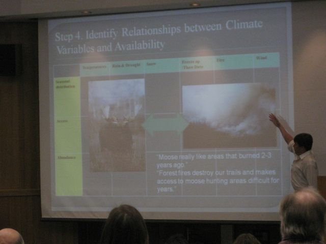
Now Todd Brinkman is talking about "Impacts of Climate Change on Local Availability of Wildlife: An Integrative Model"

[On the surface - this sounded like a reasonably sensitive study in how Alaska Natives were involved in the study.]
He went to villages and talked to local villagers to have communities self identify important species. In each village, questions like:
When does most moose harvest occur ? What factors affect . . . (he changed the slide)
Then took the reports back to the village to get their feedback and revised it until they said it was right. Developed a relationship table.
Temperatures, Rain and Drought, Snow, Fire, etc. and how these impact hunting.
Go back discuss how climate has changed in the past and then return to look at how it is happening now and thoughts about the future. Pretty interesting. Almost unanimous agreement between local hunters and the trajectory of change.
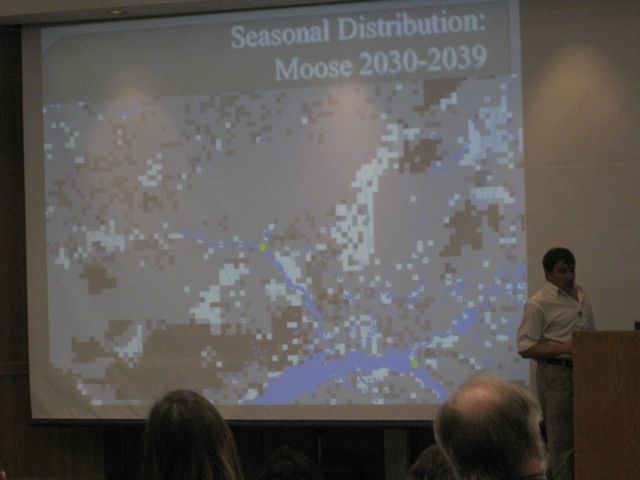
 Model will give us availability for each of the species. Some results: Moose - output for seasonal distribution for moose around Venetie. White indicates increase, black decrease, gray in-between. Then look at Access and Abundance. Looks like an overall increase in abundance. Then do this for each species
Then go back to communities with the maps and say, this could be the likely scenario of how things may change and why. Based on what they've been saying this is possible scenario and then talk about adaptation.
19 species
38% decrease
56 % no increase
6% increase
 Not because populations declining. Climate change is resulting in more challenging access. Hunting bowhead whales on sea ice. Whales are increasing, but climate changing weather and sea ice. No more multi year sea ice - it's thinner. More open water, more vulnerable.
Striking preliminary knowledge. We may get very different outcomes. Local knowledge very rich and deep on access and a little on seasonal distribution. My background is wildlife ???? - on abundance. So if we combine this all, we have the most complete comprehensive knowledge. These forms of knowledge don't compete, but complete one another.
The last two I'll give you the names and titles, but I just wasn't able to keep up.
Tracy Rogers - Future Sea Ice Dynamics and Implications for Access to the Arctic
 Evie Whitten (The Nature Conservancy) - Change and Refugia - Potential Biome Shifts in a Changing Climate
What's a biome? From the University of California Museum of Paleontology:
Results: 1. Resiliance - areas with most and least change
60% of Alaska may shift from its present biome.
. . . Much of SE Alaska shifting
Western tundra most vulnerable with least resilience
Potential expansion of Tundra swan.
Phase 2: Applied further, narrowed the goals. Use better and more data, only look at biome shifts, not species. For Alaska, Yukon, and Northwest Territories.
I'm leaving out her discussion of the methodology.
Clustering 11 biomes and 18 biomes.
Preliminary results. Will wrap up at end of September.
Greatest resillience in Aluetians, SC Alaska, Southeas, and parts of interior AK and southern Yukon.

The last session got out late and so it took me a bit to find where to go. I got in late, but judging from the program, I think I was listening to Jane Wolken from UAF talking about Impacts and Consequences of Climate Changes in Alaska's Forests. I've got a slide, but didn't get into it enough to post more than this.
Now Todd Brinkman is talking about "Impacts of Climate Change on Local Availability of Wildlife: An Integrative Model"
[On the surface - this sounded like a reasonably sensitive study in how Alaska Natives were involved in the study.]
He went to villages and talked to local villagers to have communities self identify important species. In each village, questions like:
When does most moose harvest occur ? What factors affect . . . (he changed the slide)
Then took the reports back to the village to get their feedback and revised it until they said it was right. Developed a relationship table.
Temperatures, Rain and Drought, Snow, Fire, etc. and how these impact hunting.
Go back discuss how climate has changed in the past and then return to look at how it is happening now and thoughts about the future. Pretty interesting. Almost unanimous agreement between local hunters and the trajectory of change.
Then go back to communities with the maps and say, this could be the likely scenario of how things may change and why. Based on what they've been saying this is possible scenario and then talk about adaptation.
19 species
38% decrease
56 % no increase
6% increase

 |
| Todd Brinkman |
The last two I'll give you the names and titles, but I just wasn't able to keep up.
Tracy Rogers - Future Sea Ice Dynamics and Implications for Access to the Arctic

What's a biome? From the University of California Museum of Paleontology:
Biomes are defined as "the world's major communities, classified according to the predominant vegetation and characterized by adaptations of organisms to that particular environment" (Campbell 1996). The importance of biomes cannot be overestimated. Biomes have changed and moved many times during the history of life on Earth. More recently, human activities have drastically altered these communities. Thus, conservation and preservation of biomes should be a major concern to all. For further information, please consult the references page.
Here we group biomes into six major types:
Freshwater Marine Desert Forest Grassland Tundra
Results: 1. Resiliance - areas with most and least change
60% of Alaska may shift from its present biome.
. . . Much of SE Alaska shifting
Western tundra most vulnerable with least resilience
Potential expansion of Tundra swan.
Phase 2: Applied further, narrowed the goals. Use better and more data, only look at biome shifts, not species. For Alaska, Yukon, and Northwest Territories.
I'm leaving out her discussion of the methodology.
Clustering 11 biomes and 18 biomes.
Preliminary results. Will wrap up at end of September.
Greatest resillience in Aluetians, SC Alaska, Southeas, and parts of interior AK and southern Yukon.
Pocket Gophers, Ice Patches, Pine Bark Beetles and Fire
 |
| Larry Todd |
It's after lunch and now there are three concurrent sessions. I had to finish up the last post and then got into a talk with Peter on issues of communicating science to others. I've gotten into the panel on archeological Perspectives on Environmental Adaptation.
Larry Todd just gave a presentation on "The Past as a tool for Engaging the Future" discussing his work in Colorado and how the present affects when he's looking at the past. Pocket gophers there live all year and bring soil up and change the landscape and if you don't know about the gophers, you don't understand the context of what you're looking at.
 |
| Jeremy Karchut |
 Climate Change, Melting Ice, and the Frontier of Alpine Archeology - human adaptations on mountain environments. Ice patch archeology. Human exploitation of caribou (reindeer). The largest animal in the north that people around the Arctic depend on. Go to high elevations in the summer, congregating at patches of snow and ice. Get away from heat, parasitic insects, and there's fresh water because of melting ice. People have discovered that they are pretty easy to hunt there. And so we are finding artifacts in the melting snow and ice. Ice patches different from glaciers. Noticing that a lot are starting to melt and disappear - even ones stable for thousands of years. And artifacts, final remains, insects, bone, horn, insects, birds, preserve thousands of years.
Artifacts in Swizerland and Arctic from people going over mountain passes, not just hunting. Patches accumulate, like soil, some spread uniformly, stable, preservative. Otzi - the iceman, probably associated with an ice patch, not a glacier. Also found clothing, quivers and other artifacts. I was introduced by Dr. Craig Lee who was doing surveys in Yellowstone. Showing me ice patches. Black patches - animal dung - big horn sheet in this slide. Surveyed around the ice patch and found a crooked stick - a dart (adaladal?).
A lot of this study began in Norway. Roman artifacts - even arrows with feathers, leather shoe. Entirely new look of archeology. Most just have stone artifacts, but ice preserves leather and other items.
Ice tunnel into the ice patch in Norway, with reproductions frozen in ice. An outdoor laboratory for various scientists to study this eco systems. Klimapark. Summer camps with students.
Switzerland also has a similar place. The site is melting. Found leather pants, shoes, DNA shoes it came from a goat they didn't know existed there.
Q: Goat there or trade routes?
Back to North America. Yukon and Northwest territory. Decade ago ice patch archeology started here in NA.
Artifacts back to 8000 years old. Lot of hunters lose shoes - another shoe.
Alaska - work of Richard Vanderhook, started about seven years ago. Amphitheater Mountains in Wrangell-St. Elias. 2003, this patch almost gone. Ice in many places gone and artifacts not completely gone, but they'll deteriorate soon.
Some thought patches only used by hunters, but also found animal snares (ground squirrel), baskets associated with berry picking.
 2009 Pilot ice patch project in Denali National Park. Where do you start in 6 million acre park? In early 2009 4 year old, kid picked up artifact in Teklanika River - Caribou antler arrowpoint. Mom called someone. Since soil there isn't too preservative there, so we looked around - Google Earth, then fly over in plane, finally helicopter. Big snow year in 2009 - a little too early in the season. Hadn't melted back as much as we'd like. There were doll sheep hanging out. We didn't find any cultural artifacts, but established benchmark and recovered antlers.
 Been with Chugach National Forest for about a year and a half. Ranger had already started planning. Took Kenaitze youth with us in Kenai and went to ice patches along a ridge - where caribou had been seen. But had been hunted to extinction and then reintroduced.
On way down, caribou were coming back to the ice. Not the Forest Service's priority, but have put it in to collaborate, especially with Kenaitze.
Climate change evidence clear. Best if multidisciplinary. Ice patch coming up with new information.
Anthropocene Epoch - Age of Humans - "humans have altered the planet so extensively that a new geological time interval is being proposed." Starting 8000 years ago.
 |
| Daniel Eakin |
Catastrophic die-off of pines, spruce in West. Archeological sites that burned and unburned areas. Even though sites might change, but fire exposed archeological sites.
GYE - in Yellowstone, Wind River area. Yellowstone Park is doing well, the 1989 fire put them on an even keel. White Park pines took it in the shorts. Mountains near Laramie, where I live are bad, almost totally brown and other areas around there.
Forest archaeology - generally can't see much. But with pine bark beetles and fire, visibility is totally different. All organic material gone from the ground surface. The scale of the environmental change is massive. Surface erosion, snow melt, sun light onto forest floor. Need to consider soil if you want to call it that. Where I'm from and northward into Canada, soils O Horizons over E. Horizons? I've learned that O Horizon - basically a horizon that can
[From Wikipedia
A soil horizon is a specific layer in the land area that is parallel to the soil surface and possesses physical characteristics which differ from the layers above and beneath. Horizon formation (horizonation) is a function of a range of geological, chemical, and biological processes and occurs over long time periods. Soils vary in the degree to which horizons are expressed. Relatively new deposits of soil parent material, such as alluvium, sand dunes, or volcanic ash, may have no horizon formation, or only the distinct layers of deposition. As age increases, horizons generally are more easily observed. The exception occurs in some older soils, with few horizons expressed in deeply weathered soils, such as the oxisols in tropical areas with high annual precipitation.
O horizon
The "O" stands for organic. It is a surface layer, dominated by the presence of large amounts of organic material in varying stages of decomposition. The O horizon should be considered distinct from the layer of leaf litter covering many heavily vegetated areas, which contains no weathered mineral particles and is not part of the soil itself. O horizons may be divided into O1 and O2 categories, whereby O1 horizons contain decomposed matter whose origin can be spotted on sight (for instance, fragments of rotting leaves), and O2 horizons containing only well-decomposed organic matter, the origin or which is not readily visible.
E horizon
“E”, being short for eluviated, is most commonly used to label a horizon that has been significantly leached of its mineral and/or organic content, leaving a pale layer largely composed of silicates. These are present only in older, well-developed soils, and generally occur between the A and B horizons. In regions where this designation is not employed, leached layers are classified firstly as an A or B according to other characteristics, and then appended with the designation “e” (see the section below on horizon suffixes). In soils that contain gravels, due to animal bioturbation, a stonelayer commonly forms near or at the base of the E horizon.
The above layers may be referred to collectively as the "solum". The layers below have no collective name but are distinct in that they are noticeably less affected by surface soil-forming processes.]
vary from few centimeters to much more - undecomposed organics - pine needles, rotten branches, etc. Key element is fire ecology. O Horizon as old as forest it lies under.

O Horizon containing archaeological artifacts. . . More common in most fires, total incineration of O Horizon and any artifacts - settle down - and left with assembly of artifact lying atop of he soil. Put clothesline so you can see it. This would have been invisible without the fire. A single sheep butchered in this area. Assortment of both stone and trade bit material (post contact site). Obsidian projectile points. Machine screw, trade beads. If you went to unburned forest to find this - good luck. Would be under a foot of dust.
In burns, very dirty work. REsponse time important. Not only swat team - getting there before it washes away. Be careful, right after fire hazardous - easy to get crushed by falling trees on windy days. Particularly windy days 40 miles/hour - you hear trees cracking down after 20 years. Smart thing to do is establish a safe zone in open meadow, and if wind comes up, retreat. Put your tent there.
Getting there soon enough before hidden by reveg or washes away. 20˚ slope, storm would wash it away. Recovered near 1000 artifacts, including trade beads 9 (four square feet.) Little indication of disturbance. It's amazing working in a burn after working where everything you dig out of the ground and all the work to document it and time. But after fire, basic information is what you can get out of regular excavation - in burn, it's all laid out before you.

Another site in Yellowstone. Only mechanism for burial here at higher elevation is soil creep, but over a long time, stuff doesn't move around a lot. Unlike stream bed. Vegetation here is pretty thick after 1988 fire. Coming back on terraces. In the trees some bare areas, had burned to EHorizon. No sedimentation has occurred on this land.

All these sheep traps are now in areas where the trees are bark beetle killed. Would burn in next fire.
Subscribe to:
Posts (Atom)