Friday, September 20, 2013

Anchorage To Seattle Day 5: Hazelton to Lac La Hache


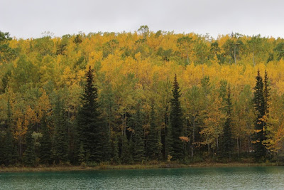
Day 4 got us from the northern end of the Cassiar Highway all the way down to where it connected to the Yellowhead Highway (37).   This is what it looked like Thursday morning.


We'd begun at the Seeley Lake campground which was a lovely spot with nice campsites, but right up against the highway with lots of trucks going by all night.

Seeley Lake


I put up a picture of the Skeena Bakery, a few miles from the campground, at the end of yesterday's post.

Once off the Cassiar, we're out of the wilder country and coming into more civilized territory.  There are still lots of trees, but the forest areas are broken up by lots of small towns and farmland.  We saw lots of timber trucks and here and there stacks of dead trees.


It's hard driving and taking pictures so this isn't too representative of the land we passed through.  We stopped for lunch at Burns Lake.

Burns Lake


Reading the local paper in the New Leaf Cafe, we saw that there's lots of local opposition to the Enbridge pipeline that would take oil to the British Columbia coast.  


Trips like these run well with audio books.  We'd listened to Eowyn Ivey's The Snow Child out of Alaska and into the Yukon and Cassiar.  I hate to be churlish - anyone who actually writes a whole novel has my admiration.  And an Alaskan first novelist who wins international awards is something I want to support.  But I felt somewhat like this commenter at the Guardian:

"The descriptions of landscape are good.
I liked the way the women in the book were described which was not stereotypical.
But the actual story became boring because it was so obvious what was going to happen at each stage. Also the interpretation that wove myth and reality was often clumsy. Needed more hard thought how to make it work. It was a good concept but the author needed a bit of help and editing support."
The blending of supernatural and real is tricky.  And as the next book began - Walter Mosley's The Gift of Fire - I thought I had an example of an experienced writer doing this much better.  And that was true at first.  He didn't fuss trying to explain things - he had confidence that the reader would figure it out.  And it's much, much shorter.  But it too seemed to struggle to hold together what it started.  Both books though had lots of good insights into human beings and how they tick.  And a number of reviewers had much more positive things to say.  For many Alaska was an exotic setting.  For me it was home, though nearly a century ago and in harder times.

I realized yesterday that many readers have no idea where the places I've been writing about on this trip are.  The map below started in The Milepost and I've added white stars to mark Day 4 and bluish ones for Day 5.  Day 4 began about 60 miles south of the junction between the Alaskan Highway (also known as the Alcan) and the Cassiar Highway. Day 5 has us rejoining the red line from the Alcan at Prince George.


I saved it pretty big and if you click on it, you can see it a little better.


We were trying to make it to Lac La Hache to have dinner at the Edelweis restaurant which I've written about in a previous trip.  But when we pulled up at 7:30pm, the closed sign was already up.  But we did have this great sky to console us.  And a full moon came up a little later.  And it felt much warmer than it had been.   

We made it to Seattle this evening and I'll do more on today's trip later.

Thursday, September 19, 2013

Anchorage To Seattle Day 3[4]: Cassiar Highway - Boya Lake to Yellowhead Highway


[Update:  Whoops, I lost a day there.  This is really Day 4] Boya Lake campground is 60 miles onto the Cassiar Highway junction with the Alaska Highway.


 From Whitehorse south the fall was not as well advanced as it had been the first two days and there are a lot more still green trees.  But as we walked briefly along the shore of Boya Lake there was a fair amount of color


We had clouds, some rain, sunshine alternating all day long.  The road is completely paved now, a big difference from when we first drove down the Cassiar and it was mostly dirt and mud.  More traffic too now.  


And there is still construction, but we didn't have much delay yesterday. 


We had a sunny lunch break with some heated up spaghetti.


It was raining ahead, and soon we were in it.  Then it was over again. 

We saw eight black bear today in four encounters - one was a mother with three cubs.  But none were conducive to photography. 


There putting in these huge power poles along the southern part of the road.  Everyone should have access to electricity, but these are so obtrusive along the highway, such an assault on the natural landscape. 


We got down to the Yellowhead Highway (Between Prince George and Prince Rupert) and camped at Seeley Lake and did a short walk along the lake at dusk.

The campsite is right along the highway and pretty noisy, but I slept well anyway.

It's great to be out in this beautiful country and away from everyday things.  We listened to The Snow Child on CD which was good for driving in the north, but it did go on and on and on.


Here's a glimpse into Day 4:  We're at the Skeena Bakery in Hazelton, a short distance from the campground.  We discovered this on our trip this way three years ago.  Like Bridges Cafe in Whitehorse, they have a public service function too - here they work with special needs adults. 


Wednesday, September 18, 2013

Anchorage to Seattle Day 3: Haines Junction to Boya Lake

We were at the library at Whitehorse so I could post and then went to lunch nearby.


 Bridges is a small cafe with healthy food and they also take in youth from a nearby development/training program to give them job skills.  We had a great black bean soup - part was pureed but she left in some of the whole beans to give it more texture. 

 Back to the library to get the van and off down the road. 


 This metal bridge made a racket as we crossed over from Teslin, Yukon.  Below is a shot of Teslin and the bridge.


The trees are quite in full fall colors here yet.  Just starting.  


This is one of three salmon signs at the Teslin lookout point. 


 As we headed southeast toward the Cassiar Highway cutoff (just before Watson Lake) we began to get blue sky and great clouds.   We ended up at Boya Lake campground, about 60 miles from the junction of the Cassiar and Alaska Highways. 


 We've passed about six bicyclists with well loaded panniers.  Three in one group, a single, and a pair.

Doing this quickly in Dease Lake, BC at the learning center.  Sun's out again. 

Tuesday, September 17, 2013

Anchorage to Seattle Day 2B: Into Canada, Sunshine on a Cloudy Day

There was road construction between the US Customs station and the Canadian Customs station.  But what an incredible background.


The birch and aspen and other plants were so yellow and golden and even red, that despite clouds it was ‘sunny’ everywhere we looked. 


White River, I think

These are both at Kluane Lake.  Lots of low hanging clouds, some rain, and snow higher up.


The swans are headed south.  We saw maybe a dozen, but this pair was close to the highway at a place where we could stop.  Trumpeters.


As the title says, it was cloudy, but the bright fall colors made it look sunny.  And toward 7:30pm (we lost an hour entering Canada) the sun did come out just past Haines Junction at Paint Rock.  We camped near by at Pine Lake Campground.


Anchorage to Seattle Day 2: Fall Walk To Hidden Lake Tetlin National Wildlife Refuge


[At Yukon Public Library in Whitehorse]

 It's Fall up here!  This is on the road at Tetlin National Wildlife Refuge right near the Canadian Border.


We stopped at Hidden Lake trail - 2 miles round trip - for a bit of morning exercise before what seemed like the inevitable rain came.


We grazed on blueberries, cranberries, and sweet ripe rose hips. 


click to enlarge
At the lake, Joan spotted in the binoculars a large moose way on the other side.  By the time a got the telephoto lens on, it had hidden in the trees.  You can barely see her in this picture. 


Here are some other shots along the trail.


A little down the road is the Refuge Visitor Center which closes after September 15 and we were there September 16.  But the view was still available.
There was a reminder that Washington DC's reach is far.  I don't think cutting back on the hours here is too big a loss.  It's nice and should be available, but it's not essential to be open longer.


And more spectacular view along the road.