Jake Metcalf, Deborah Williams, and Leonard Lausen. Thank you for your work. I spent two weeks earlier this month traveling around the state for my employer so I understand what you've been going through.
Our plans, yes 2, meet all the Federal and state requirements. All equal in size.
Plans - chart showing that it meets all the requirements.
Supreme Court past ruling: "where possible, all Municipality's excess population should go to one other district in order to maximize effective representation of the excess group."
REspecting Distric Boundaries - Matsu 5
Respecting City Boundaries - Fairbanks 1 district, all cities in tact
Juneau - SE deserves 4 entire house districts, Matsu
This is going very fast - taking pictures of the slides.
Matsu has five districts that they deserve
Fairbanks - Districts 6 78 9 10
Valdez/Richardson Hwy
Anchorage - Districts 16-31 - No political gerrymandering
Community names match districts
Kenai
HD 39 - Nome/Upper Yukon - at least one district needs to be huge. Cuirently District 6, this is the new big one, but more compact than 6
SE HD 1,2,3 same in both alternatives - heard NPR story about your meeting in Petersburg and complaints about splitting them up. OUrs leaves them intact. Districts compact.
Differences in Alternatives:
HD 4 different - with and without Yakutat
HD35
Bethel 36, Dillingham (37), Kodiak/Cordova(38)
Rights plans meets all the principles and requirements.
Urge the burough to adopt one of these too. We also support AFFR's request for extension of time for comments to discuss VRA analysis. Thank you
White: Jake, p. 10-11 - population data, Native+1 I understand. That's total population?
Lausen: Yes
White: Numbers on first alternative a little small, so I'm ... laughter
???: Damn small
White: I understand Natives unanimously did not like your plan?
Lausen: Not, ...I do not recall any negative remarks made about the plan.
Williams: Our plan, with respect to 39, many of the Athabascan villages would be associated with Majority/minority district. Alt. 2 in particular, we have a compact District 36, postiive feedback, no general or specific negative comment
Lause: Dillingham BB wanted more watershed. Alt 2 able to provide that. REsponed to feedback.
Williams: What the board sees, Alt 2 presents a 37 that is contguous by water an air. Land connection separated by keeping entire lake burough intact. Wanted to present intact for Lake Burough. Make argument that district is contiguous since transportation there is all by air and boat. Alt there is a land connection, Alt 2, not.
White; 35 runs all the way to Sand Point, 37 connected ..
Lausen: 37 connected Bristol Bay and Aleutian Burough. Connected by water, but if board doesn't like that, offer it combined by land.
Williams: Southern of 35 is S. Cook Inlet Native communities.
White: thank you.
Torg: I'm sure we'll have more.
Lausen: We believe they're good, but we have contingency plans to get numbers higher if voting rights act expert requires higher numbers.
Williams: We hope that VRA expert considers in Bristol Bay considers that Census did not ask about citizenship,because i the canneries there are considerable non-citizens.
White: Your plan does break Kenai Borough in two places.
Williams: Kenai had to be broken twice for ???Voting Rights?
Lausen: Kenai could be intact, depending on the VRA expert's number requirements.
Torg: thank you. We'll be in touch. Next MOA.
9:58am At ease
I'll try to get visuals up soon, but things are moving right along.
Friday, May 06, 2011
AFFR Presents Plan They Say Meets All Requirements
 |
| Carl Marrs and Joe McKinnon |
AFFR - Alaskans for Fair Redistricting is presenting their plan.
4 Native Majority House Districts
2 Native Minority House
2Narive Minority Senate
Pairs H35 - Kodiak with Aleutians
Included everyone identified as Native and part Native as DOJ will.
Preserves much of the Board's proposals for rural Alaska but eliminates non-contiguous pairings.
Interior highway and Bethel is also like Boards.
YK Delta to Denali Borough - has vulnerability in ours and the board's draft plan. But some commonalities. SE integration not as strong as other districts, but should be ok for VRA.
H35 includes Kodiak, and several others - SEldovia
H36 Aleutians, loses in Chiknik and picks up ...
Parts connected with S Anchorage are now back in Kenai.
AFFR plan for Fairbanks similar to previous, but excess is placed in Interior, not Nome.
Anchorage - similar to previous and s. Anchorage no longer connected to Kenai.
Military bases split. Plan for Anchorage has better neighborhood cohesion than any other we've seen.
Adjusted plan avoids placing incumbents in same districts, except in SE and except for 7, no incumbents are paired. Our maps show homes of incumbents, existing districts shown in black lines.
Concerned that board's plan unnecessarily pairs incumbents. Has the appearance of gerrymandering not legally defensible and could make the plan vulnerable and hurt public confidence.
Concerned Lisa Handley's analysis is incomplete or unreleased - so we are all shooting in the dark. Without this, we hired our own consultant, Engstrom's analysis is included in the plan.
Prof.
Given the lack of a plan so far, we suggest extending the time for public comment one week.
We're presenting a plan that meets all the federal and state criteria.
Torgerson: Thank you. Appreciate the work.
White: Thank you guys for all the hard work. VRA expert you had. Ms. Handley in her last report 2001, which wasn't issued until May ?? - she indicated last time in district you have as 38, you needed 49% to be effective.
Not Marrs: I believe he reviewed the existing District?? - We can ask about that and get a response for the board.
White: Yes, that would be helpful. Ms. Handley did say 38 needed more to make that district effective.
McKinnon: He looked at the 2006 and 2008 elections.
White: provided us with ??? everything but SE. Is that right? Any of those native incumbents being paired?
McKinnon:: Representative Thomas.
White: You have Saxman in 1 or ?
McKinnon:: Saxman in 1. We pulled Haines and Skagway out because they have low Native populations.
White: Alaska plus Native or Alaska plus all?
McKinnon:: Plus All. His analysis based on total Native plus all.
White: I think AI+AN is total population. Page 9 of your report. What is AI/AN?
McKinnon:: American Indian/Alaska Native
White: Page 13, table - number your VRA expert used?
McKinnon:: Difficult to make analysis if population below 35%. Based on voting age population, but didn't feel significant difference. % lower than that might result in Native ???
White: District 2 35.7 is total population, then based it on that, a little lower. A % or two below that didn't matter.
McKinnon:: There were no results between 17 and 35%. Reluctant to draw conclusions because of lack of data.
White: 2 maps you provided have diffeent numbers. 30 and 34 are the same districts but have different numbers. Kenai = 30, then Kenai = 34 Tenana Chiefs part of AFFR? They were not happy about being reduced from majority to effective. Did they endorse this.
McKinnon:: They have not.
9:26 Break
Thursday, May 05, 2011
How is the Alaska Redistricting Board Like the Pakistani Government? Either They Are Incompetent or They Are Intentionally Concealing
The Alaska Redistricting Board has its final public hearing Friday May 6, 2011.
Where? Anchorage Legislative Information Office (LIO) 714 W. 4th Ave Room 220.
When? Presenting plans from 9am-12am.
Public testimony from 2pm- 6pm
NOT IN ANCHORAGE? You can go to your nearest LIO office or
listen to the Audio-Stream at: http://alaskalegislature.tv.
Alaskans with no access to an LIO may testify via the toll-free number 1-855-463-5009.
But how would anyone know this? As of 10pm Thursday May 5, it's very hard to find on their website or their Facebook Page says nothing is scheduled. Let me show you.


It gives the Juneau office address. (The physical meeting is in Anchorage, but it is available statewide at LIO offices.)
Well, maybe it's on their Facebook page.
 Good try. There's even something only 15 hours old, but nothing I can see about the May 5 meeting. Let's try the Events page.


This is 2011. Government agencies have learned a lot about how to educate the public about what they are doing and how to participate in the process.
The Department of Transportation hires consultants to help them set up meetings for the public where they walk people through maps and models so people can see how roads are designed and where they are planned so that citizens can give them useful information about how the project will impact neighborhoods and ways it could be improved for everyone's benefit. I went to one about Tudor and Lake Otis and another about the Seward Highway last fall.
I don't see anything like that happening here. And this isn't the first time their website and Facebook page didn't have information about an upcoming meeting. Almost exactly one month ago, on April 4, I had a post Is The Redistricting Board Hiding? which found almost exactly the same problems as today. The staff made all the necessary updates the next day when I pointed this out. But really . . . again?
GW Bush said something about being fooled once . . .
This is a board whose job is highly political and from the git go, people assume that because there are four Republicans and one Democrat, the Board is going to try to draw the lines to favor Republicans. Politically gerrymandering is against the law according to the board's attorney. So not being as open as possible only raises those suspicions about what they are trying to hide.
People are speculating whether the Pakistani government was incompetent and didn't know that for five years Bin Laden was living within spitting distance of the Pakistani West Point or did they know and just not do anything about it.
I can't help but wonder if the Redistricting Board is incompetent or intentionally making it as difficult as possible for people to know where the meetings are.
In part, it doesn't make sense to hide. The various groups with the most stake - the Republican Party, the Democratic Party, and several other politically active groups - all know how to find the board. Not making it really clear on the website only discourages the general public who don't have enough information to make too much trouble anyway.
Where? Anchorage Legislative Information Office (LIO) 714 W. 4th Ave Room 220.
When? Presenting plans from 9am-12am.
Public testimony from 2pm- 6pm
NOT IN ANCHORAGE? You can go to your nearest LIO office or
listen to the Audio-Stream at: http://alaskalegislature.tv.
Alaskans with no access to an LIO may testify via the toll-free number 1-855-463-5009.
But how would anyone know this? As of 10pm Thursday May 5, it's very hard to find on their website or their Facebook Page says nothing is scheduled. Let me show you.
Double click to enlarge and sharpen all the images.

Here's what I see when I open the page on my laptop. Pretty picture. But information would be nicer. I have to scroll down to get that.
 |
| Double click to enlarge and sharpen |
This is their main page. The last news item (today is May 5) was on April 13. Now if you work really hard and read all the fine print there are two places on the right where you can get a pdf link to a five page document which has tomorrow's meeting on the bottom of page 3 and top of page 4. Why can't they just post it clearly on the first page?
Are there other pages on their website you can find this more easily?

FAQ's, almost 2/3 of the way to their deadline, are coming soon.

[Again, double click to see it clearly.] In the Media Center tab we find out their last press release was March 8.

Their last public notice was April 12 and it takes you to the state public notice page for an old public notice.


Their calendar page has a small notice and when you click on the morning part you get this pop up window that gives you the time and says Alaska Legislative Information office. And there's a map link.

It gives the Juneau office address. (The physical meeting is in Anchorage, but it is available statewide at LIO offices.)
Well, maybe it's on their Facebook page.


You have no upcoming events!!
I happen to know that there's one more place to look - the State of Alaska public notice webpage.

At first I didn't see the board listed. I had to go through it again before I found it. And I clicked on it.

It says April 24, 2011, Statewide Teleconference. But it's now May 5. I'll click it anyway.

And BINGO! I'm rewarded for my patience. Let me get out my reading glasses. (You'll notice I've already made this extra large - it bleeds into the side panel.)
Before March 22, I'd never ever been to the State Public Notice Website. I didn't even know it existed. But on that day I asked Board Chair John Torgerson how they were planning to let people know about the meetings. And he told me about this website. You can see and hear for yourself. I also asked if they were going to put any notices or ads in newspapers. You can see in his body language as well as hear his words in the video.
This is 2011. Government agencies have learned a lot about how to educate the public about what they are doing and how to participate in the process.
The Department of Transportation hires consultants to help them set up meetings for the public where they walk people through maps and models so people can see how roads are designed and where they are planned so that citizens can give them useful information about how the project will impact neighborhoods and ways it could be improved for everyone's benefit. I went to one about Tudor and Lake Otis and another about the Seward Highway last fall.
I don't see anything like that happening here. And this isn't the first time their website and Facebook page didn't have information about an upcoming meeting. Almost exactly one month ago, on April 4, I had a post Is The Redistricting Board Hiding? which found almost exactly the same problems as today. The staff made all the necessary updates the next day when I pointed this out. But really . . . again?
GW Bush said something about being fooled once . . .
This is a board whose job is highly political and from the git go, people assume that because there are four Republicans and one Democrat, the Board is going to try to draw the lines to favor Republicans. Politically gerrymandering is against the law according to the board's attorney. So not being as open as possible only raises those suspicions about what they are trying to hide.
People are speculating whether the Pakistani government was incompetent and didn't know that for five years Bin Laden was living within spitting distance of the Pakistani West Point or did they know and just not do anything about it.
I can't help but wonder if the Redistricting Board is incompetent or intentionally making it as difficult as possible for people to know where the meetings are.
In part, it doesn't make sense to hide. The various groups with the most stake - the Republican Party, the Democratic Party, and several other politically active groups - all know how to find the board. Not making it really clear on the website only discourages the general public who don't have enough information to make too much trouble anyway.
Forests, Wildlife, Sea Ice, and Biomes (Yeah, What's a Biome?)
The official title of this afternoon panel was: Meeting Climate Information Needs in Alaska. I'm losing speed here so my coverage isn't too thorough.

The last session got out late and so it took me a bit to find where to go. I got in late, but judging from the program, I think I was listening to Jane Wolken from UAF talking about Impacts and Consequences of Climate Changes in Alaska's Forests. I've got a slide, but didn't get into it enough to post more than this.
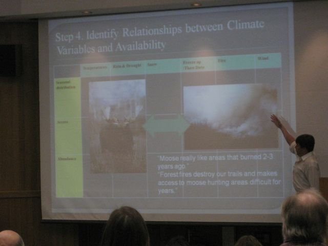
Now Todd Brinkman is talking about "Impacts of Climate Change on Local Availability of Wildlife: An Integrative Model"

[On the surface - this sounded like a reasonably sensitive study in how Alaska Natives were involved in the study.]
He went to villages and talked to local villagers to have communities self identify important species. In each village, questions like:
When does most moose harvest occur ? What factors affect . . . (he changed the slide)
Then took the reports back to the village to get their feedback and revised it until they said it was right. Developed a relationship table.
Temperatures, Rain and Drought, Snow, Fire, etc. and how these impact hunting.
Go back discuss how climate has changed in the past and then return to look at how it is happening now and thoughts about the future. Pretty interesting. Almost unanimous agreement between local hunters and the trajectory of change.
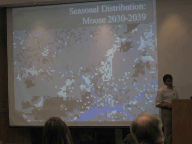
 Model will give us availability for each of the species. Some results: Moose - output for seasonal distribution for moose around Venetie. White indicates increase, black decrease, gray in-between. Then look at Access and Abundance. Looks like an overall increase in abundance. Then do this for each species
Then go back to communities with the maps and say, this could be the likely scenario of how things may change and why. Based on what they've been saying this is possible scenario and then talk about adaptation.
19 species
38% decrease
56 % no increase
6% increase
 Not because populations declining. Climate change is resulting in more challenging access. Hunting bowhead whales on sea ice. Whales are increasing, but climate changing weather and sea ice. No more multi year sea ice - it's thinner. More open water, more vulnerable.
Striking preliminary knowledge. We may get very different outcomes. Local knowledge very rich and deep on access and a little on seasonal distribution. My background is wildlife ???? - on abundance. So if we combine this all, we have the most complete comprehensive knowledge. These forms of knowledge don't compete, but complete one another.
The last two I'll give you the names and titles, but I just wasn't able to keep up.
Tracy Rogers - Future Sea Ice Dynamics and Implications for Access to the Arctic
 Evie Whitten (The Nature Conservancy) - Change and Refugia - Potential Biome Shifts in a Changing Climate
What's a biome? From the University of California Museum of Paleontology:
Results: 1. Resiliance - areas with most and least change
60% of Alaska may shift from its present biome.
. . . Much of SE Alaska shifting
Western tundra most vulnerable with least resilience
Potential expansion of Tundra swan.
Phase 2: Applied further, narrowed the goals. Use better and more data, only look at biome shifts, not species. For Alaska, Yukon, and Northwest Territories.
I'm leaving out her discussion of the methodology.
Clustering 11 biomes and 18 biomes.
Preliminary results. Will wrap up at end of September.
Greatest resillience in Aluetians, SC Alaska, Southeas, and parts of interior AK and southern Yukon.

The last session got out late and so it took me a bit to find where to go. I got in late, but judging from the program, I think I was listening to Jane Wolken from UAF talking about Impacts and Consequences of Climate Changes in Alaska's Forests. I've got a slide, but didn't get into it enough to post more than this.
Now Todd Brinkman is talking about "Impacts of Climate Change on Local Availability of Wildlife: An Integrative Model"
[On the surface - this sounded like a reasonably sensitive study in how Alaska Natives were involved in the study.]
He went to villages and talked to local villagers to have communities self identify important species. In each village, questions like:
When does most moose harvest occur ? What factors affect . . . (he changed the slide)
Then took the reports back to the village to get their feedback and revised it until they said it was right. Developed a relationship table.
Temperatures, Rain and Drought, Snow, Fire, etc. and how these impact hunting.
Go back discuss how climate has changed in the past and then return to look at how it is happening now and thoughts about the future. Pretty interesting. Almost unanimous agreement between local hunters and the trajectory of change.
Then go back to communities with the maps and say, this could be the likely scenario of how things may change and why. Based on what they've been saying this is possible scenario and then talk about adaptation.
19 species
38% decrease
56 % no increase
6% increase

 |
| Todd Brinkman |
The last two I'll give you the names and titles, but I just wasn't able to keep up.
Tracy Rogers - Future Sea Ice Dynamics and Implications for Access to the Arctic

What's a biome? From the University of California Museum of Paleontology:
Biomes are defined as "the world's major communities, classified according to the predominant vegetation and characterized by adaptations of organisms to that particular environment" (Campbell 1996). The importance of biomes cannot be overestimated. Biomes have changed and moved many times during the history of life on Earth. More recently, human activities have drastically altered these communities. Thus, conservation and preservation of biomes should be a major concern to all. For further information, please consult the references page.
Here we group biomes into six major types:
Freshwater Marine Desert Forest Grassland Tundra
Results: 1. Resiliance - areas with most and least change
60% of Alaska may shift from its present biome.
. . . Much of SE Alaska shifting
Western tundra most vulnerable with least resilience
Potential expansion of Tundra swan.
Phase 2: Applied further, narrowed the goals. Use better and more data, only look at biome shifts, not species. For Alaska, Yukon, and Northwest Territories.
I'm leaving out her discussion of the methodology.
Clustering 11 biomes and 18 biomes.
Preliminary results. Will wrap up at end of September.
Greatest resillience in Aluetians, SC Alaska, Southeas, and parts of interior AK and southern Yukon.
Pocket Gophers, Ice Patches, Pine Bark Beetles and Fire
 |
| Larry Todd |
It's after lunch and now there are three concurrent sessions. I had to finish up the last post and then got into a talk with Peter on issues of communicating science to others. I've gotten into the panel on archeological Perspectives on Environmental Adaptation.
Larry Todd just gave a presentation on "The Past as a tool for Engaging the Future" discussing his work in Colorado and how the present affects when he's looking at the past. Pocket gophers there live all year and bring soil up and change the landscape and if you don't know about the gophers, you don't understand the context of what you're looking at.
 |
| Jeremy Karchut |
 Climate Change, Melting Ice, and the Frontier of Alpine Archeology - human adaptations on mountain environments. Ice patch archeology. Human exploitation of caribou (reindeer). The largest animal in the north that people around the Arctic depend on. Go to high elevations in the summer, congregating at patches of snow and ice. Get away from heat, parasitic insects, and there's fresh water because of melting ice. People have discovered that they are pretty easy to hunt there. And so we are finding artifacts in the melting snow and ice. Ice patches different from glaciers. Noticing that a lot are starting to melt and disappear - even ones stable for thousands of years. And artifacts, final remains, insects, bone, horn, insects, birds, preserve thousands of years.
Artifacts in Swizerland and Arctic from people going over mountain passes, not just hunting. Patches accumulate, like soil, some spread uniformly, stable, preservative. Otzi - the iceman, probably associated with an ice patch, not a glacier. Also found clothing, quivers and other artifacts. I was introduced by Dr. Craig Lee who was doing surveys in Yellowstone. Showing me ice patches. Black patches - animal dung - big horn sheet in this slide. Surveyed around the ice patch and found a crooked stick - a dart (adaladal?).
A lot of this study began in Norway. Roman artifacts - even arrows with feathers, leather shoe. Entirely new look of archeology. Most just have stone artifacts, but ice preserves leather and other items.
Ice tunnel into the ice patch in Norway, with reproductions frozen in ice. An outdoor laboratory for various scientists to study this eco systems. Klimapark. Summer camps with students.
Switzerland also has a similar place. The site is melting. Found leather pants, shoes, DNA shoes it came from a goat they didn't know existed there.
Q: Goat there or trade routes?
Back to North America. Yukon and Northwest territory. Decade ago ice patch archeology started here in NA.
Artifacts back to 8000 years old. Lot of hunters lose shoes - another shoe.
Alaska - work of Richard Vanderhook, started about seven years ago. Amphitheater Mountains in Wrangell-St. Elias. 2003, this patch almost gone. Ice in many places gone and artifacts not completely gone, but they'll deteriorate soon.
Some thought patches only used by hunters, but also found animal snares (ground squirrel), baskets associated with berry picking.
 2009 Pilot ice patch project in Denali National Park. Where do you start in 6 million acre park? In early 2009 4 year old, kid picked up artifact in Teklanika River - Caribou antler arrowpoint. Mom called someone. Since soil there isn't too preservative there, so we looked around - Google Earth, then fly over in plane, finally helicopter. Big snow year in 2009 - a little too early in the season. Hadn't melted back as much as we'd like. There were doll sheep hanging out. We didn't find any cultural artifacts, but established benchmark and recovered antlers.
 Been with Chugach National Forest for about a year and a half. Ranger had already started planning. Took Kenaitze youth with us in Kenai and went to ice patches along a ridge - where caribou had been seen. But had been hunted to extinction and then reintroduced.
On way down, caribou were coming back to the ice. Not the Forest Service's priority, but have put it in to collaborate, especially with Kenaitze.
Climate change evidence clear. Best if multidisciplinary. Ice patch coming up with new information.
Anthropocene Epoch - Age of Humans - "humans have altered the planet so extensively that a new geological time interval is being proposed." Starting 8000 years ago.
 |
| Daniel Eakin |
Catastrophic die-off of pines, spruce in West. Archeological sites that burned and unburned areas. Even though sites might change, but fire exposed archeological sites.
GYE - in Yellowstone, Wind River area. Yellowstone Park is doing well, the 1989 fire put them on an even keel. White Park pines took it in the shorts. Mountains near Laramie, where I live are bad, almost totally brown and other areas around there.
Forest archaeology - generally can't see much. But with pine bark beetles and fire, visibility is totally different. All organic material gone from the ground surface. The scale of the environmental change is massive. Surface erosion, snow melt, sun light onto forest floor. Need to consider soil if you want to call it that. Where I'm from and northward into Canada, soils O Horizons over E. Horizons? I've learned that O Horizon - basically a horizon that can
[From Wikipedia
A soil horizon is a specific layer in the land area that is parallel to the soil surface and possesses physical characteristics which differ from the layers above and beneath. Horizon formation (horizonation) is a function of a range of geological, chemical, and biological processes and occurs over long time periods. Soils vary in the degree to which horizons are expressed. Relatively new deposits of soil parent material, such as alluvium, sand dunes, or volcanic ash, may have no horizon formation, or only the distinct layers of deposition. As age increases, horizons generally are more easily observed. The exception occurs in some older soils, with few horizons expressed in deeply weathered soils, such as the oxisols in tropical areas with high annual precipitation.
O horizon
The "O" stands for organic. It is a surface layer, dominated by the presence of large amounts of organic material in varying stages of decomposition. The O horizon should be considered distinct from the layer of leaf litter covering many heavily vegetated areas, which contains no weathered mineral particles and is not part of the soil itself. O horizons may be divided into O1 and O2 categories, whereby O1 horizons contain decomposed matter whose origin can be spotted on sight (for instance, fragments of rotting leaves), and O2 horizons containing only well-decomposed organic matter, the origin or which is not readily visible.
E horizon
“E”, being short for eluviated, is most commonly used to label a horizon that has been significantly leached of its mineral and/or organic content, leaving a pale layer largely composed of silicates. These are present only in older, well-developed soils, and generally occur between the A and B horizons. In regions where this designation is not employed, leached layers are classified firstly as an A or B according to other characteristics, and then appended with the designation “e” (see the section below on horizon suffixes). In soils that contain gravels, due to animal bioturbation, a stonelayer commonly forms near or at the base of the E horizon.
The above layers may be referred to collectively as the "solum". The layers below have no collective name but are distinct in that they are noticeably less affected by surface soil-forming processes.]
vary from few centimeters to much more - undecomposed organics - pine needles, rotten branches, etc. Key element is fire ecology. O Horizon as old as forest it lies under.

O Horizon containing archaeological artifacts. . . More common in most fires, total incineration of O Horizon and any artifacts - settle down - and left with assembly of artifact lying atop of he soil. Put clothesline so you can see it. This would have been invisible without the fire. A single sheep butchered in this area. Assortment of both stone and trade bit material (post contact site). Obsidian projectile points. Machine screw, trade beads. If you went to unburned forest to find this - good luck. Would be under a foot of dust.
In burns, very dirty work. REsponse time important. Not only swat team - getting there before it washes away. Be careful, right after fire hazardous - easy to get crushed by falling trees on windy days. Particularly windy days 40 miles/hour - you hear trees cracking down after 20 years. Smart thing to do is establish a safe zone in open meadow, and if wind comes up, retreat. Put your tent there.
Getting there soon enough before hidden by reveg or washes away. 20˚ slope, storm would wash it away. Recovered near 1000 artifacts, including trade beads 9 (four square feet.) Little indication of disturbance. It's amazing working in a burn after working where everything you dig out of the ground and all the work to document it and time. But after fire, basic information is what you can get out of regular excavation - in burn, it's all laid out before you.

Another site in Yellowstone. Only mechanism for burial here at higher elevation is soil creep, but over a long time, stuff doesn't move around a lot. Unlike stream bed. Vegetation here is pretty thick after 1988 fire. Coming back on terraces. In the trees some bare areas, had burned to EHorizon. No sedimentation has occurred on this land.

All these sheep traps are now in areas where the trees are bark beetle killed. Would burn in next fire.
QPF -
 [Warning: I'm getting flaky here. I just couldn't keep up, but you can get a sense of the talk. People are leaving now for concurrent session. I have to divide into three.]
Quantitative Precipitation Forecasting. The State Climatologist, Peter Olsson, is the lunch speaker.
1. Water Vapor
2. Cooling of the Atmosphere
Lifting agents - Large - warm front; Small - mountains

Cloud microphysics - cloud droplets to raindrops (2000 microns) - We don't really know what happens in the cloud. Can't do in a cloud chamber. Numerical models - scale from micron to thousands of kilometers.
Disclaimer #1: Gridded finite models and Spectral models
#2: differences between models used to be huge. Not so much any more.
Model Grids - [I'm not quite close enough to read the slides from my table near the electric outlet]
Global Climate models
Regional climate model
High resolution forecast model

Now he's talking about Orographic Precipitation - Compared to Girdwood, we have a 5:1 difference. Which side of the mountain you're on.
From Wikipedia:
Orographic precipitation, also known as relief precipitation, is precipitation generated by a forced upward movement of air upon encountering a physiographic upland (see anabatic wind). This lifting can be caused by two mechanisms:He went through various technical problems in predicting.
1. The upward deflection of large scale horizontal flow by the orography.
2. The anabatic or upward vertical propagation of moist air up an orographic slope caused by daytime heating of the mountain barrier surface.

Mountains play significant role in precipitation and we have lots of mountains. We tend to under predict in the winter and overpredict in summer. QPF is not a cookbook for predictions near the mountains.
How does this affect climate models? A lot more guesswork going into what they have to do.
I simply can't capture all he's saying. You probably need to contact him if you want the details.

Shad O'Neel, Can We Predict Global Sea Level Change?
Shad O'Neel, USGS Research Glaciologist. [This guy gave a great talk. I have more video I'll try to put more up later. He really knows his stuff and is animated about it. Well worth a look. And if you are particularly interested in the relationship between glaciers and sea-level, definitely watch!] [NOTE: I'm putting this up quick - translation: no editing until later maybe.]
Not all glaciers change because of climate change, but some based on geometry of the basin they live in.
Who cares?
Glaciers out of equilibrium, so we're in for a change whether we like it or not, and if climate continues to change, it will be greater.
Large tourism base, visiting to see our glaciers. Cruise ships, recreational, aviation to see glaciers. So big that state parks have built visitor centers, but now they can't see the glaciers from them any more.
What may be more important is culture's ability to adapt to sea level rise. If there is a 2 foot sea level rise in Florida, we're screwed. But we can deal with it. But what about the sea level islands in Asia - a lot more people?
Water from our glaciers. Snow that lands on glaciers has different chemistry because not on dirt and when it goes into the water it's totally different from other water going into the sea. So the eco systems near the glaciers are very different and changes the currents that go up to the Arctic - fisheries, flooding, coastal erosion, hydro electric. Sea level rise. Glacials modulate the sea level budget - if we want to understand sea level rise, we have to understand glaciers.
1-3% loss of total land loss by 2080. $100 billion problem by 2080. The longer we wait to deal with it, the bigger the problems.
Implications of sealevel rise.
1. Adding or subtracting new water -
2. Steric
Chart of different contributions from small glaciers, ice sheets, terrestrial storage, and ???.
Bottom panel shows problem because we can't measure and compare perfectly with space born - capture the same trend, but not exactly the same.
What does global sea level rise mean? How to measure it? Each component tricky. We're doing pretty good job. Sea level budget.
Glaciare Surface Mass Balance - slide is showing time lapse of and Icelandic glacier changing from winter and summer - if it melts more than it snows it gets smaller. This is what we thought was glacier health and what controlled sea level budget. If positive it grows, negative should shrink, if 0 stays the same.
There's more than just snow and melt. How do you measure? Especially mountain glaciers. Ice sheets easier. Like a bucket of water. But if I threw the water over the carpet - more like mountain glaciers. Traditionally measured with poles - raid electric supply stores and they think we're crazy. Bury pole in the winter. Meters of snow every winter and meters of melt in the summer.
Now, we need to understand what these measures mean for glaciers as proxy of climate. Two benchmark glaciers in Alaska. Gulkana and Wolverine - small and simple. Chosen because easy logistics. Alaska glaciers go back to late 60s. Do they mean anything. Can we use them as proxy for regional and then global context?
Yeah, ok job, but asking those questions.
Record from the glaciers.
Washington state glacier has greatest loss. But both continental has dwindling trend. Coastal glacier - Wolverine - has been up and down. More influenced by winter snow than summer climate. No more recovery periods.
World Glacier Monitoring service tries to integrate global records.
Global record shows decreasing glaciers. Old measures. Now we have satellite pictures. Long time series data is supercritical, but motivation has changed from 50's when no one was thinking of climate change and were just curious.
Do we have the right signal? Whats the response time. Changes that happened when? Do the space measurements compare well with these traditional measurements? Or is there a difference that warrants caution? Can we model the measurement?
World Glacial Inventory
Looking at all the mountain glaciers 19 different regions. Gray - complete inventories. Clear, incomplete. You're probably surprised we don't know how many glaciers there are. In US, we're lacking behind China and Russia. We don't know as much as we know. Shocking to me that this is the state of the science now.
What about our measurement skills? Getting better at measuring over broad spatial area. Airplanes fly over glacier and measure surface and then return years later. A lot more sophisticated the sticking poles in, but doesn't give us density. Now laser from space. Discovered there were lakes under Antarctica that rise and drain with lasers.
Mountain Glacier Changes
1950-2010
Alaska ones are long interval change.
1. Not every region represented
2. Alaska dominates - we have a lot of ice
3. Similar shapes as Wolverine and Gulkana - decreasing curve
West Antarctica similar curve
East Antarctica actually gaining ice.
Only since space born measurements can we have confidence to say losing mass at increasing rates.
Graph - can't even see clear white bar for glaciers, but sea level % is huge. Massive loss of glaciers compared to ice sheets.
Forecasting - what people want from glaciologists. We have handle of measuring sea level change, but can't predict? Just temperature? Some regions changing temperature faster than others? Some traction but not enough. The gorilla in the corner is ice dynamics, well illustrated by Chugach. Big bullesye over Columbia. One part gaining another part losing. Columbia accounts for have the mass loss in this mountain range. Why is this so important and why we ignored it. Scale of this is hundred meters tall, instantaneous transfer of mass from land ice to sea. Not just stagnant disintegration of glaciers. Like Manhattan going out into the ocean. Imagine trying to study this. Just can't.
All these couplings and feedbacks that are non-linear. This process at Columbia is happening fast - ocean, atmosphere involved - we don't have a handle yet, so we can't predict sea-level rise. Major speed up.
Why the uncertainty? Ice dynamic thing. Can't predict it.
Climate Change Solutions - Across Institutions, Cultures and Landscapes
[My notes here are on the fly. My intent is to give a sense of what is happening here today, but this is not any sort of official record. Contact individual speakers if you have specific questions. Consider this a starting point.]
This is the opening forum of the Classrooms for Climate Symposium at UAA. I'm here because this is of interest and also I was asked to blog this. So, my disclosure: they've given me a media pass and I think that includes lunch and all sessions. They've even linked here on their website and also set out the conditions:
I got here after the opening roundtable of youth participants and while the brand new Chancellor Tom Case introduced outgoing Chancellor and new Chair of the US Arctic Research Commission Fran Ulmer. And she's introduced the panelists and now Margie Brown, President and CEO of Cook Inlet Regional Corporation is just finishing up.
Beth Pendleton, Regional Forester, US Forest Service, Alaska is now talking about USFS projects in Alaska around climate change - effects of fish and trees and people.
She mentioned research projects that will be presented here in the next few days and also about the student interns being used. Climate change isn't the end of life, but it will challenge us with uncertainty and opportunities.
9:39am Leslie Holland-Bartels US Geological Survey (USGS) - there was a relationship between the old agency Mineral Management Service. .... Challenge of science is all the uncertainty of our research. TV soundbites don't convey that. Places on the landscape - we have species and many are migratory here in the north. One story - gotwit, an Alaska shorebird in summer, then to New Zealand via China Yellow Sea. Makes the 7000 mile trip to New Zealand non-stop. The longest recorded. How? It gets onto the weather pattern to slingshot south. How will climate change affect that. Will the species adjust or stop migration. Will it be able to find other places to feed? How will it change the sites this bird visits? Will it gain enough weight to make the flight? How will the foodwebs in these 3 locations change? It requires different thinking. We need to think globally. Growing up, we didn't have the tools of the perspective. This is just one of thousands of species that call Alaska home. We have to multiply this perspective by the thousands to understand our challenges.
Each of us from different agencies have different perspectives and how we look at this. Some of us sit on the Climate Change Round Table where we can share. New connections with UAA - physical and social sciences.
Joe Balash as deputy commissioner Alaska Department of Natural Resources. [I think I need some staff.] Climate change is affecting roads - ice roads to north aren't open long enough and we are looking at building year round roads. Other challenges of climate change are coming from Congress - bills to limit CO2 emissions will affect us in many ways.
Thinking through all the consequences that carbon limitations would have are things we have to think through as we develop our oil and gas. Those consequences affect our revenue picture as a state. It has the players in Juneau in special session right now arguing over a surplus. In a decade we could be arguing over a decade.
The threat of carbon regulation is something we have to keep in mind, but there are other things being implemented today - endangered species act. Through the actions of NGO's we are literally surrounded by endangered species. Those additional requirements of critical habitats put more restrictions that impact our economy and people, and while not impossible to deal with, while not impossible, will seriously affect us.
The long term projections on how our climate will change affects us in the short and long term. That's the challenge we face and will continue to deal with. Previous speakers also identified science as the key. We try to make our decisions as often as possible on the best science. We also rely on scientists. Will continue to manage those resources with ever changing climate in mind.
Larry Hartig, Commissioner of Environmental Conservation. We are a science and engineering based agency. Most of our rules come from Federal laws implement through state agencies. As climate change rules develop and change, we watch closely. We will have to enforce them and we want them to make sense here. We're different in many ways, and how climate change affects us. I thought I would try to key on today: Climate change impacts in Alaska.
Mitigation and Adaptation: Mitigation is what is causing the change - like greenhouse gas emissions. Adaptation is how do you prepare yourselves regardless of the causes. I came here four years ago after private industry. Then, everyone was thinking about mitigation, while adaptation is more important to Alaskans.
I remember a NYTimes interview on climate change in Alaska, and the longevity of carbon dioxide in atmosphere (140+years) and affect on the waters etc. Given the concentrations in the models out there, we'll be dealing with this for 400 years. NYTimes headline was, "Palin only concerned about adapation" as though trying avoid mitigation.
That's changed quite a bit. Now talking about adaptation. Also, as people started talking about it. Waxman-Marky bill, only focused on natural environment and not on human impacts or on infrastructure we depend on - water sources, highways, etc. In Alaska, climate change here, not just temperature, but actually phase changes - ice changes to water, permafrost turns to mush, and wave surges that can hit our coasts. Major changes.
Four years ago, state not looking at Climate change - Palin was first administration to look at climate change. In spring 2007 thinking about this. That fall, series of storms with fuel tanks full of fuel and no coastal ice and we could see the erosion and all the fuel headed for the water. Fortunately, that fuel all got moved. But it was desperate.
People themselves worried, one night decided to self-evacuate. They are out in the middle of nowhere. No roads. Snow machines, Planes. Elderly people. State and federal government long ways off. Governor formed climate change subcabinet that I chair - how to prepare for this. Idea to bring key cabinet members dealing with this to be ready. Also looking at 31 threatened communities. Immediate Action Workgroup. 1. Emergency preparedness 2. Prevention 3. Community planning. Kivilina knew they needed to move, but didn't know how. One place Corps of Engineers said no- that's permafrost and will melt. So planning. We aren't social engineers, telling people how to live their lives. When we talk to them is provide viable options, but they have to make the decisions. 4. Those that can't be re-placed. Came up with plans, put training into place in most vulnerable communities. Planning established a grant program with two types of grants - mini grants for assessment on community impacts and larger planning grant if you did have to move. All that put into place in 1 or 2 years within start of Palin administration. Workgroups from people all over the state. Needed to build consensus. Several reports on our climate change website.
Some of the regulations would affect heating oil in rural Alaska. If they look at carbons emitted by turbines could cause serious problems. A lot of agencies working on these issues, all science driven. We should be able to get more of a consensus on the science and not argue over things we don't need to argue over. It does seem more of a consensus is being built. One is that adaptation needs to be addressed as well as mitigation. And some of the dire predictions ???? [don't want to misquote him so I'll leave it vague].
I'm going to put this up now and add photos and videos later.
Q: If consensus by scientists on climate change, but survey says 87% of Republicans don't believe climate change is real?
Ulmer: 90% of scientists believe in climate change. Science literacy in US is abominable. We rank in lower 10% on science literacy. How will be able to compete? President of Boeing yesterday said he feared future of US because we aren't taking science and development seriously enough and not seeing it as part of national security in addition to economy. At all levels - including industry - no respect for science. How has science been changed to something you can choose to believe or not. Scientific literacy part of being a modern nation. I would challenge each of us in each of our capacities, we have to think about this, work on it. Other panelists?
Hartig: Not just climate change, many arenas. At meeting in SF for Permanent Fund and economist talked to me, saying, if you look at all things people struggle with, the hardest to grasp is climate change. Complicated, you can't see, won't impact most people any time soon, or broad impact not obvious, people see they have less complicated options - buy new vehicle or like the old one. People don't get the science. Have to look at behavioral factors and how people make decisions.
Regional EPA director. Back in Nixon generation there was a big fight over leaded gas. Most people kept buying leaded because it was a few cents cheaper. Until they took away the option, people would use it despite the science. Right now it's too complicated.
Jeff: Disconnect - while there were tornadoes destroying part of the country, Congress was cutting climate monitoring money from NOAA's budget and thinking how brilliant they were on cutting the budget.
 |
| (l-r) Hartig, Balash, Holland-Bartels, Pendleton, Brown, Ulmer |
He is an independent blogger and opinions expressed by Steve are his own and do not reflect official positions of UAA or the U.S. Forest Service.
 |
| Margie Brown, CIRI |
Beth Pendleton, Regional Forester, US Forest Service, Alaska is now talking about USFS projects in Alaska around climate change - effects of fish and trees and people.
She mentioned research projects that will be presented here in the next few days and also about the student interns being used. Climate change isn't the end of life, but it will challenge us with uncertainty and opportunities.
 |
| Holland-Bartels |
Each of us from different agencies have different perspectives and how we look at this. Some of us sit on the Climate Change Round Table where we can share. New connections with UAA - physical and social sciences.
Joe Balash as deputy commissioner Alaska Department of Natural Resources. [I think I need some staff.] Climate change is affecting roads - ice roads to north aren't open long enough and we are looking at building year round roads. Other challenges of climate change are coming from Congress - bills to limit CO2 emissions will affect us in many ways.
Thinking through all the consequences that carbon limitations would have are things we have to think through as we develop our oil and gas. Those consequences affect our revenue picture as a state. It has the players in Juneau in special session right now arguing over a surplus. In a decade we could be arguing over a decade.
The threat of carbon regulation is something we have to keep in mind, but there are other things being implemented today - endangered species act. Through the actions of NGO's we are literally surrounded by endangered species. Those additional requirements of critical habitats put more restrictions that impact our economy and people, and while not impossible to deal with, while not impossible, will seriously affect us.
 |
| Hartig and Balash |
Larry Hartig, Commissioner of Environmental Conservation. We are a science and engineering based agency. Most of our rules come from Federal laws implement through state agencies. As climate change rules develop and change, we watch closely. We will have to enforce them and we want them to make sense here. We're different in many ways, and how climate change affects us. I thought I would try to key on today: Climate change impacts in Alaska.
Mitigation and Adaptation: Mitigation is what is causing the change - like greenhouse gas emissions. Adaptation is how do you prepare yourselves regardless of the causes. I came here four years ago after private industry. Then, everyone was thinking about mitigation, while adaptation is more important to Alaskans.
I remember a NYTimes interview on climate change in Alaska, and the longevity of carbon dioxide in atmosphere (140+years) and affect on the waters etc. Given the concentrations in the models out there, we'll be dealing with this for 400 years. NYTimes headline was, "Palin only concerned about adapation" as though trying avoid mitigation.
That's changed quite a bit. Now talking about adaptation. Also, as people started talking about it. Waxman-Marky bill, only focused on natural environment and not on human impacts or on infrastructure we depend on - water sources, highways, etc. In Alaska, climate change here, not just temperature, but actually phase changes - ice changes to water, permafrost turns to mush, and wave surges that can hit our coasts. Major changes.
Four years ago, state not looking at Climate change - Palin was first administration to look at climate change. In spring 2007 thinking about this. That fall, series of storms with fuel tanks full of fuel and no coastal ice and we could see the erosion and all the fuel headed for the water. Fortunately, that fuel all got moved. But it was desperate.
People themselves worried, one night decided to self-evacuate. They are out in the middle of nowhere. No roads. Snow machines, Planes. Elderly people. State and federal government long ways off. Governor formed climate change subcabinet that I chair - how to prepare for this. Idea to bring key cabinet members dealing with this to be ready. Also looking at 31 threatened communities. Immediate Action Workgroup. 1. Emergency preparedness 2. Prevention 3. Community planning. Kivilina knew they needed to move, but didn't know how. One place Corps of Engineers said no- that's permafrost and will melt. So planning. We aren't social engineers, telling people how to live their lives. When we talk to them is provide viable options, but they have to make the decisions. 4. Those that can't be re-placed. Came up with plans, put training into place in most vulnerable communities. Planning established a grant program with two types of grants - mini grants for assessment on community impacts and larger planning grant if you did have to move. All that put into place in 1 or 2 years within start of Palin administration. Workgroups from people all over the state. Needed to build consensus. Several reports on our climate change website.
Some of the regulations would affect heating oil in rural Alaska. If they look at carbons emitted by turbines could cause serious problems. A lot of agencies working on these issues, all science driven. We should be able to get more of a consensus on the science and not argue over things we don't need to argue over. It does seem more of a consensus is being built. One is that adaptation needs to be addressed as well as mitigation. And some of the dire predictions ???? [don't want to misquote him so I'll leave it vague].
I'm going to put this up now and add photos and videos later.
Q: If consensus by scientists on climate change, but survey says 87% of Republicans don't believe climate change is real?
Ulmer: 90% of scientists believe in climate change. Science literacy in US is abominable. We rank in lower 10% on science literacy. How will be able to compete? President of Boeing yesterday said he feared future of US because we aren't taking science and development seriously enough and not seeing it as part of national security in addition to economy. At all levels - including industry - no respect for science. How has science been changed to something you can choose to believe or not. Scientific literacy part of being a modern nation. I would challenge each of us in each of our capacities, we have to think about this, work on it. Other panelists?
Hartig: Not just climate change, many arenas. At meeting in SF for Permanent Fund and economist talked to me, saying, if you look at all things people struggle with, the hardest to grasp is climate change. Complicated, you can't see, won't impact most people any time soon, or broad impact not obvious, people see they have less complicated options - buy new vehicle or like the old one. People don't get the science. Have to look at behavioral factors and how people make decisions.
Regional EPA director. Back in Nixon generation there was a big fight over leaded gas. Most people kept buying leaded because it was a few cents cheaper. Until they took away the option, people would use it despite the science. Right now it's too complicated.
Jeff: Disconnect - while there were tornadoes destroying part of the country, Congress was cutting climate monitoring money from NOAA's budget and thinking how brilliant they were on cutting the budget.
Majora Carter: Discovering the Bronx River

 Marjora Carter opened the University of Alaska Anchorage and Chugach National Forest's Classrooms for Climate Symposium Wednesday night.
She told how her family moved north to the South Bronx in the 1940s and she grew up in a neighborhood that was always characterized as blighted and which became the trash dump of New York City.
It was only when she was forced by finances to move back home while in grad school that she began to see her neighborhood differently. While walking her dog one night, they wandered into an illegal dump site and just beyond the site she saw the Bronx River for the first time.

Today that dump site is a beautiful park because of Carter's ability to get grants and coalesce the neighborhood. In her talk, she brought together a variety of issues - how the waste in the neighborhood caused health problems - including affecting kids' learning abilities. How the neighborhood and its people were essentially abandoned and it was known as a dangerous neighborhood of crime and drugs, and as a convenient place for the rest of the city to dump its trash.
But starting with park and then going on to green roofs, Carter worked on programs that created hope for the hopeless through training programs and jobs on turning the neighborhood green. Ex-cons in one of the programs - BEST - went from being what she called 'the most expensive citizens' to productive citizens. They got off government programs and became tax payers. The green roofs lowered temperatures in the summer, caught rain water (reducing the runoff that would normally need to be treated by the city water systems, and added greenery to the concrete environment. She cited studies that showed all sorts of improvements from higher grades to lower teen pregnancy rates for people who had greenery in their environments.
 |
| Majora and Judy Bonds |
I'm reminded that the world's narrative has changed greatly in the last 30 years. People understand that the environment is important and lots of people are quietly doing many important projects, generally below the radar. But the work is being done.
Here's a bit of video of Majora Carter's talk at UAA:

Oh, btw, today Carter has her own for profit consulting firm teaching businesses and communities how to go green. Green, she said last night, stands for money as well as a clean environment.
Afterward a group from Transition Town Anchorage were discussion the talk and implications for Anchorage.
Wednesday, May 04, 2011
"this is not civilization"
 That's the title of a novel by Robert Rosenberg that was a University of Alaska Anchorage and Alaska Pacific University Book of the Year for this past year. And probably what tonight's UAA Classrooms for Climate conference meeting speaker Majora Carter was thinking when she decided to clean up her South Bronx neighborhood.
The UAA/APU Books of the Year program is a powerful partnership between University of Alaska Anchorage and Alaska Pacific University that brings faculty, staff, and community members together to understand common themes. The books serve as the catalyst for discussions of larger issues of local and international significance.
[This] program started in 2006 as part of a Ford Foundation Difficult Dialogues initiative--one of only 26 in the country--to provide a safe environment on campuses for discussions of challenging topics. UAA and APU are now national leaders in this area.
For me the title was intriguing, plus, it was about a Peace Corps experience. Every PC experience is different, yet there are common themes - feeling totally lost as you enter a foreign world and language while people have unrealistic expectations of you and want to use you for their own purposes which you don't understand, making great friends, and always wondering whether you are doing more harm than good. Here's Rosenberg's hero as he arrives in his town in Kyrgyzstan.
In Kyzyl Adyr-Kirovka Jeff received what felt like a hero's welcome. Over his first few days his neighbors on Karl Marx Street introduced themselves in a continuous wave. Expectations were high; they seemed to believe he could change their lives. The attention was jarring. . . the villagers offered gifts of warm bread, eggplant and cabbage from their family plots, strawberry and cherry compote, boiled mutton, and plastic bags filled with cold triangles of fried dough. They explained just to what length Anarbek [his host] had gone to refurbish the old brick townhouse. The previous year the occupants had repatriated to southern Russia. The house had served a six-person family for three decades, so the village deemed it large enough for one American. Anarbek had arranged for its purchase with the village akim. For an entire month he had shown up each day with his wife and two daughters to renovate the home and bring it up to Peace Corps standards. He had installed a Western toilet (the bathroom did not have running water; Anarbek would work on that, they said) and a series of electric radiators (the street's electricity seemed sporadic; he would work on that). His daughters had hung printed curtains made from bedroom sheets, pounded out the carpets, and scrubbed the several years' accumulation of Central Asian dust off the floors. Anarbek requisitioned a heavy steel gate for the front door, a strict requirement stipulated by the Peace Corps, but in the neighbors' opinion an unnecessary precaution. For the previous quarter of a century, Kyzyl Adyr-Kirovka had known no crime.You can learn more about the Book of the Year program and the two new books for next year
Part 2:
Wednesday, May 4th
Wendy Williamson Auditorium.
7pm - FREE (free parking too)
Majora Carter presents -
Hometown Security: Climate Adaptation, Social Innovation and Local Solutions
The theme for the two books this year was service. That theme and the title "this is not civilization" seem a good segue into another UAA activity - Classrooms for Climate.
Classrooms for Climate is organized by the Chugach National Forest and UAA in partnership with the Alaska Coastal Rainforest Center, Alaska Geographic, and the Northern Forum. Alaska is ground zero for climate change, and the Chugach and neighboring landscapes, with world famous glaciers and watersheds, are an extended classroom for researchers, educators, and students around the world seeking to understand the potential physical, biological, cultural and socio-economic impacts. Each of the participating institutions recognizes its own unique role as a “classroom” for understanding and responding to climate change. All are committed to working across geographic and institutional boundaries to build knowledge and craft sustainable and effective solutions. This symposium is a first step in bringing together partners in inquiry, education, and management from across Southcentral, Alaska and beyond.
The partnership between the university and the Forestry Service picks up on the theme of service. And tonight's speaker at Wendy Williamson Auditorium, McArthur Award winner Majora Carter, probably thought that life in the Bronx was less than civilization and decided to do something about it.
Majora Carter simultaneously addresses public health, poverty alleviation, and climate change adaptation as one of the nation’s pioneers in successful urban green-collar job training and placement systems. She founded Sustainable South Bronx in 2001 (with the help of a small Forest Service grant) to achieve environmental equality through economically sustainable projects informed by community needs. By 2003, she coined the term: "Green The Ghetto" as she pioneered one of the nation's first urban green-collar job training & placement systems. Her organization spearheaded new policies and legislation that fueled demand for those jobs, improved the lives of all New Yorkers, and has served as a model for the nation.There's a lot more about her (and links to even more) at the UAA website. From all I've heard about this woman, the free talk tonight at Wendy Williamson is another one of those incredible Anchorage opportunities to meet a world class thinker and doer. It would be nice to think that our mayor and assembly members might show up to learn about how to integrate economics and environment and humanity.
Subscribe to:
Posts (Atom)