Showing posts sorted by date for query Campbell Creek under Seward Highway. Sort by relevance Show all posts

Friday, October 18, 2013

East and West Finally Connected - Very Low Key Opening Of Campbell Creek Bike Trail Under Seward Highway

The sun came out for this ceremony.  There were construction workers and some DOT employees.  A few cyclists and some dogs and walkers.  And Channel 2 and Channel 11 and the Anchorage Daily News had camera folks.  As well as an unnamed blogger.

And there were two Muni employees who'd been working to make this happen since 1991 they said.  This was the culmination of a lot of work - getting this train connected under the Seward Highway.  And now it's done.


It was hard getting good angle without blocking the sun which is already pretty low on the horizon at noon.  It says, "East & West Finally Connected."

The absence of anyone of note - mayor, assembly, representatives, even department heads - or any real ceremony was probably fitting.  The real workers behind making this happen over the long term were probably the two women who had the cake and the blue lemonade container.  Chong Kim, the DOT engineer who has overseen the actual construction, was at a meeting I was told.  There was no ceremony and no ribbon cutting even though this is probably the most ambitious individual bike trail construction project in Anchorage since the Coastal trail was built.  This connected bike paths that were separated by the Seward Highway and its two access roads.  It's true, one could scramble under the old bridges and many did.  The top photo has a picture of the old bridge.  And here are some before and after shots.  But this is a recognition that bike paths do matter. 


There are still some things to work on - crossing Lake Otis for example.  Crossing Dowling was finished this summer.  But this was the biggie - four bridges under a major highway and access roads.  One of the women there from Anchorage Public Works told me there was a $10 million estimate for a similar underpass at Lake Otis.  She smiled wryly when I suggested they use the $20 million allocated to bulldoze Elmore through the University land, a project only the engineers seriously want and all the people living near by strongly oppose.  Money that was put into the state budget in the very last minutes before the state budget was passed this year in Juneau. Over the opposition of all the state and local representatives of the area. 


It's hard to take a picture of something that isn't there.  Until yesterday, there was a fence blocking this bridge right here.  For me, the removal of the fence is the real opening of this trail.


Here's what it looked like earlier this week.


These are snow fences to protect the trail and trail users from snow being plowed from the road above.  Technically, they aren't supposed to plow snow from the highway into the creek anyway, but just in case, and to keep other debris falling from the highway off the people below.  


The construction is still going on.  I think they may still need to connect the bike trail on the road above to the bike trail, but it seems it would make sense to do it from the same side of the creek as the trail.  So, I'm not sure what they are doing here.  


And this last shot is from the bridge east of the highway where the fence was removed yesterday.  The cake table is just on this side of the bridge.

Friday, October 11, 2013

UPDATE: Campbell Creek Bike Trail Under Seward Highway Almost Done

I checked on the Campbell Creek bike trail under the Seward Highway project last night (Thursday, Oct. 10).  My last post on this was Sept. 10.   On Sept. 6 I posted pictures of the unpaved trail and what it looked like in the past when you had to carry your bike under the low bridges. 

It's now paved and almost done.  This morning I called the project engineer Chong Kim who said he's hoping it will be done next week.  In this first photo - from the west side - you can see the fence like structure.  It's designed to deflect snow coming from a snow plow on the road above and keeping it off the trail and off people walking or riding on the trail.  Kim said five more are supposed to go up and they are the last major parts that need to be done. 


This shot is from the east looking west.  There are four new bridges - the east access road, which you see here; the north bound Seward Highway;  south bound Seward Highway; and the west access road. 


The reason you can't really use this part of the path yet is this fence on the bridge on the west side. Once the other

Looking at this fence, turn 180˚ and you see the picture below.


This is looking at the path and bridge from the west. 


Above I'm looking east from under one of the bridges.


Looking up I saw what I thought were lights, but they were strange looking and I couldn't see them quite as clearly as I can now looking at the photo. 

I asked Kim about them.  They are LED lights which use much less energy than regular lights would.  But they're pretty expensive and he expressed concern about vandalism or theft.  I asked if I should post about this.  He said yes and to let cyclists know that if they see anyone tampering with the lights to call the police (and maybe take a picture as well.)  I guess he figured not too many LED thieves read this blog, but cyclists might. 


Taking the trail further east - toward Lake Otis - I took this shot of the leaf carpeted trail.

Tuesday, September 10, 2013

UPDATES: Green Screen Mystery, Campbell Creek Under Seward Highway, and Sugar Shack Reopened


Chong Kim is the project engineer in charge of the Seward Highway reconstruction from Tudor to Dowling, which includes the Campbell Creek bike trail.  I'd gone for a bike ride today to keep some hold of my sanity and looked for the DOT office behind the donut shop at Lake Otis and Tudor.


He apologized for not answering my phone call.  I'd left a message asking when the bike path would be done.  He said he was still trying to pin down the contractor before calling me back, but since weather is such a big factor, it's hard to say.  He figures about 2 or 2.5 weeks until it's all done.  By September 30th.  [I'd posted anyway a few days ago with then and now pictures.]

[UPDATE Oct 11:  I've updated with pictures from Oct. 9.  Mr. Kim told me maybe next week.]

In our chat I had a minor revelation.  He looked at the pictures I took last week of the path and he pointed to some hardware connected to the ground and then pointed to some green, transparent fabric on the wall in his office.  They will attach some fencing to that hardware.  Suddenly I had a flash - those strange green screens we'd seen where the Campbell Creek trail goes under Martin Luther King Blvd.  The ones with the images of the skier, biker, and walker.  The screens that we'd shaken our heads over in wonder at who would have put such boring art up.  I made some disparaging comments in a post this summer about a similar (unfinished) screen (below) where the Campbell Creek trail goes under the new bridge at Dowling.  (You used to have to cross the street at this point.)

It turns out these are to keep trail users from being covered with snow by a snow plow clearing the road above them.  Another reminder to myself to not jump to conclusions, but if it's strange, to assume there is something I'm not getting. Am I going to wait next winter to video tape a snow plow at this spot?  Don't hold your breath. 

It all makes sense now.  As it turns out, he said the Feds (EPA and another agency) say they may not plow into the creek anyway from the Seward Highway, but Chong said debris falls from passing vehicles so it's still good to have there. 

A Hopeful Note

I also talked to the office engineer who said, when I wanted to know the date for the bike trail completion, "You and everybody else.  That's the only thing people call to ask about."

I just want to document that piece of feedback about public interest in the bike trails, because I doubt that they are keeping track of that sort of feedback for the DOT administrators or for the legislators in Juneau, some of whom think people who ride bikes are anti-capitalists. 

And finally, the Sugar Shack reopened today.  It's not giant news, but this is a small local business that got trashed by vandals last May.  The thoughtless vandals cost this business almost four months of business and inconvenienced all the people who pass by here and regularly stop for a beverage.


Friday, September 06, 2013

Campbell Creek Bike Trail Under Seward Highway Almost Ready

The target date for completing the bike trail under the Seward Highway is Fall 2013.  The trail is there, but the path hasn't been paved nor has the path otherwise been finished off.  But they have completely new bridges in and we walked by there the other evening.
[UPDATE October 19, 2013 - It semi-officially opened today and is open for riding.]

From the west side you can walk the trail, under the highway bridge.


Here's what this looked like in 2007.]


When the State does a project, they tend to obliterate the landscape and then build it back up from scratch.  I'm sure they have good reasons for it.  In this case the bridge has been expanded greatly.  Before there was just a little edge along the path under a bridge you had to duck to get under in spots.  Now the space next to the creek is bigger, it seems, than the creek.  

Here's what this spot looked like in May 2012:


And here's going under the bridge the other day:


And near the same spot in 2008.  This was the whole trail then right against the water.  And when the creek was really high, the whole trail was gone.  The heavy equipment is between me and the water above - also the orange fencing is along the water.  And the bridges were shorter and lower.


There are four bridges - (from the east) first the frontage road, then the northbound highway, southbound highway, and the western frontage road.  Here's a little past the first bridge (maybe even the second one.)

And here's what that used to look like:


Once you get out from under the highway, instead of the one-bike winding path through the fireweed, there's more bike superhighway up to this bridge which is blocked for now.   At the right times, you can watch the spawning salmon from this bridge.  We're very close to The Wild Berry tourist trap at this point, just west of the Seward Highway (see map below). 


Getting to this bridge used to look like this:


Turning around at this point, it now looks like this:


One more picture of the bridges - now looking east from the west side. 


And here's a map for the area.  I started on the east and went to the west, then turned around and went back where the wooden bridge was blocked off.


When this is done, you'll be able to ride from downtown out to Westchester Lagoon up the Chester Creek trail to Goose Lake and the the University crossing either over or under all streets via tunnels and bridges.  At the university you have to cross a parking lot and a few streets to get to the bridge at Tudor and Bragaw (now Elmore), and then on the Campbell Creek bike trail.  There's a bit of a break in the trail at Lake Otis, but then you get back on a wooded trail that will go under the Seward Highway and then on to just past Victor near Dimond coming out at Dimond High School.  Then there zigging and zagging through neighborhoods to connect to the trail in Kincaid park, and from there you can get back downtown.

The Trails of Anchorage site  says it's 13 miles from Kincaid Chalet to Goose Lake, and I'm guessing it's not much less for the rest of the loop I described.

Here's a link to the Arctic Bicycle Club.


Friday, July 12, 2013

Campbell Creek Path Under Seward Highway, Yellow Pond Lilies, Moose in Cow Parsnips and an All Around Beautiful Day

 I can't remember so much warm (into the 70s) weather over a summer.  We've had good spells, but nothing like most of June and a good start in July.  So when B suggested a bike ride today to the Coastal trail, I readily agreed.


I wanted to see how the bike trail they're building under the Seward Highway is doing.  It's blocked off for now, but here's what they've got so far.


It seems the basic trail pad is done, now they just have to pave it.

Though they've taken a perfectly charming path through the bushes and made it as much like freeway as you can do for a bike path.

This could be done by the end of the summer as the project manager told me last year.


You can already ride UNDER Dowling Road.  Though this big black thing adds nothing for me.  Again, superhighway bike trails.   Yet we don't have money for school lunches. I know, the money comes from separate budget allocations from the feds, but still.  [UPDATE 9/10/13:  I learned these are to keep snow plows on the road above from dumping snow on people on the trail.  See this updated post.]


Ducks at Taku Lake


The lily pond is in Pamela Joy Lowry Memorial Park - at the north end of Arlene from Dimond High.  A little gem of a neighborhood park. 
The National Park Service  gives some background on the Yellow Pond Lily (Nuphar polysepalum) 

. . . Another interesting metabolic adaptation found in Nuphar is anaerobic respiration, which is respiration without oxygen. This process allows the plant to respire using no oxygen in the process, which is a very useful adaptation in the oxygen-poor environment found in standing water such as ponds and lakes. Anaerobic respiration is a complex chemical process that results in the production of ethanol (the same alcohol that you find in mixed drinks) within the plants cells. Ethanol is a poisonous substance in the plant and must be excreted away quickly in order to avoid harm to tissues. One way this toxin is removed is by evaporating the alcohol back up through the balloon-like aerenchyma cells to the surface of the water. One common name for a closely related yellow pond lily in Europe is "brandy-bottle" because of the strong smell of alcohol coming from its flowers (which are at the end of long, tube-like stems filled with aerenchyma tissue). This plant forms large tubers that sprout new clusters of leaves in the spring when ponds and lakes thaw after the long winter. These tubers are storage organs for the sugars that the plant produces each summer – they can be eaten after roasting or boiling, and are quite tasty!


 We passed this bench inside Kincaid Park.  A nice way to remember a young man who liked the guitar.

This is for Jeremy who likes all things electrical.  I liked the quality and message of the graffiti.  We're not sure what this was for, though there was a long trench out toward the inlet on the other side of the trail, and B speculated it might have something to do with the windmills out on Fire Island.


There was a bunch of spruce grouse chicks and then I saw the hen between the trees.

Nothing special here, I just like birch trees.


I continue to be amazed at how well moose can hide in plain sight. These are huge animals, yet they can merge in with the scenery.  I would have gone right past this one without seeing it if B hadn't called it to my attention.  Even though its hind quarters were practically sticking out onto the bike trail.

Would you know there was a moose in there amongst the cow parsnip?  Still can't see it?

Here's a closer look.


 The cow parsnip must have been really good, because he didn't seem to mind all the bikes zooming by with a few feet of his behind.  


Saturday, September 22, 2012

Campbell Creek Flooding Demonstrates Why Title 21 Is So Important


The white line is approximately where the shoreline is normally.   This is one of the first houses as Campbell Creek moves into populated area, so there are no artificial constrictions above stream that would raise the water higher here. 


I'm on the bike trail, the white line is about normal shoreline.

As developers try to push back the set back distance from creeks proposed in the Title 21 provisionally approved, this recent flooding gives a good example of why other cities have much stricter setbacks than Anchorage.


You can see the white line again over by the posts and the sign at the normal shoreline where the creek is supposed to go under the bridge.

 
And below is Campbell Creek just after crossing under Lake Otis.  It's been constrained by the concrete barriers under the road right here and it has fairly steep banks, so it's kept relatively close within its banks.  But even so you can see the difference between Thursday and Friday. (Note:  We were already at flood levels on Thursday.) The little white lines on each photo show the water line for Friday and the same place on Thursday. The vertical white line in the upper right just shows the distance from the base of the tree to the water.


And most telling of all, the pipe in the lower right is completely covered on Friday. 


And as I continued on the bike trail, I could see that the creek strayed far beyond its normal banks.   At the point in the picture below, there are houses between the trail and the creek. 


I decided to go off the trail and find a relatively dry pathway through the woods on the right.  It had some elevation.  But then I got out of the woods and to the soccer fields at Waldron Park.


In the above picture I'm looking back to where I came out of the woods onto the soccer fields.  There was a long, narrow body of water bordering the fields.  As I went down toward the field from the woods, I knew the ground would be soggy but I was hoping I could jump to the grassy island.  Well, both shoes were soaked by the time I leapt to the little grass patch, which wobbled like a water bed under me.  I think it was floating. 


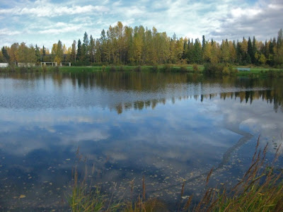
This is Waldron Lake, on the edge of the soccer fields.  This area was saved this year by a bill in the legislature which bought the property to preserve it as a park.  This year the governor didn't veto the appropriation like he did last year.  As I looked at the lake, it seemed that this big open body of water was better equipped to absorb some of the flooding.   Nah, don't you think they should drain the lake and put in condos?  We need to get tax dollars from this land.  Well, what we get is a natural flooding abatement and water filtration plant that would cost the city hundreds of millions to match if this lake and the creek and the green belt around the creek weren't here.

Then I wandered on down to the Seward Highway and the project begun this summer to raise the four bridges to allow a real bike trail under the highway instead of the dirt and rock obstacle course that's been the way to get past the highway all these years.


This picture shows my bike under the first bridge in August 2008, negotiating the rocks and the dirt.  You can see the second bridge in the background (and then there are two more) and the normal water level.


Here's pretty much that same spot earlier this summer after they closed it off for the construction.  


And here it was Friday morning. (You can click on the picture to get it bigger and clearer. The bottom of the fence is in the water which was about three and a half feet below the bottom of the bridge.  The trail was completely obliterated.  You can compare the water levels to the first of these three pictures. 

If I've understood correctly (it's hard to keep current with the many changes), the builders in town have gotten the Planning and Zoning Commission to shrink the setback from creeks and waterways for new development.  I understand that people want to build on as much land as possible.  But this week's flooding along the creeks shows why those setbacks are necessary.  Are floods like this normal?  Not really. But there has been speculation that the shrinking polar ice cap is having an effect on our weather patterns.  If that's true, this may be the new normal.

This storm and the flooding highlight the problems of having developers be the main lobbyists to roll back the changes on Title 21. (Not counting those who have been to meetings to explain that Title 21 is directly related to UN resolution 21 on global climate change and is an international conspiracy to take over the world.)  They want to make as much money as they can developing land and while I'm sure the vast majority of the developers do not want to have their projects flooded - even after they've collected their money and gone - I am sure that they simply discount the safety, health, and aesthetic goals set into the Title 21 process by citizens panels over the years.  The creek set back is one of the more visible problems with the changes they are proposing.  There are many, many more that will have long term negative effects on Anchorage as a livable city.

The Anchorage Citizens Coalition has a lot more detailed information of what's going on.  They'll need people to contact their Assembly members right away.