Showing posts with label maps. Show all posts

Tuesday, August 24, 2021

Board Gets Interesting Testimony And Works On Mapping Skills

 Morning so far has included 

Board discussing how they want to learn the mapping software during the day today

Testimony by:

James Squires Gulkana

Tom Begich - State Senator and very involved in past two redistricting processes

Rhonda Pitka -  Village of Beaver

Aaron Shutt - CEO Doyon


It's 10:38 now and the Board members are working together and individually on their computers to create districts in SE Alaska.  Basically, this is a learning exercise so they can get skilled on the mapping software.  They are each asking questions and staff are giving suggestions for what to do.  

Here are my notes from this morning.  Of most substantive interest is the testimony.  Regular disclaimers:  these are rough notes, a guide to what's happening at the Board, but not verbatim and not without errors.  


AK Redistricting Board Notes

Aug. 24, 2021

Meeting 

9am - 10:15am


9:17  Peter Torkelson demonstrating online website.

9:44 Board has been talking about the new software and how they want to learn the software.  

9:48  Board is going to take public testimony - looking for people on line who might want to testify.  Two people in line

9:50 James Squire, Gulkana District 9 describing district.  Even to Whittier - we have little in common - people living in Super Cold down to Whittier.  Delta to Valdez - north of Alaska range to Whittier and Palmer.  Distance to travel from one part to another.  Need something more reasonable, similar climates, life style.  They drive to Fairbanks, NOT Palmer.  Alaska Range is important boundary.  I understand you need to get population.  Alaskans in Palmer have little to do with what goes on here.  We go to FB and FB comes to us for recreation.  

John:  Thanks very much appreciate the detail and brevity.  If you’ve been looking online, can you give the online mapping project 

Nicole - Thanks for excellent, precise testimony.  

James Squire - We don’t go to Fred Meyers in Palmer, Go to Fairbanks.  Difference between -4 and -50.  

Sen. Tom Begich, from Anchorage - Thanks for letting me testify.  Couldn’t yesterday.  Commend you on your process.  I’ve served in 2001 and 2011 cycle.  First - caution, if you separate into group you’ll run into  interlocking puzzle problem when you put them together.

  1. Two piece criteria - Federal and Constitutional guidance.  There are no existing districts.  They are built by scratch.  We start by looking at Burroughs because they are by definition socio-economic integrated.  You talked about starting with SE because has only one direction to go.  Having done that, there is a way to have a core district with Yakutat.  
  2. Mr. Squires says Delta should be connected with FB.  He’s right.  No reason for Delta or Valdez to be connected with FB.
  3. Matsu has to find that .6 percent and Anchorage will too, while Kenai and FB have to shed population.  Anchorage 15.8 will have to go south to get the extra population.  It can be done.
  4. Matsu won’t be able to go south to Anchorage.  
  5. Heard Doyon testimony.  Areas of Doyon region required by 39 can be returned to Doyon.

Starting with Socio Economic first, existing districts are irrelevant.

Start with SE

Take testimony.  

John:  Thanks Senator, that was a lot to absorb.  Couldn’t follow it all.  You have a lot of experience.  

Melanie:  Thank you.  For those not familiar with this, we have to follow Alaska Constitution, that we start with blank slate, look at Constitution.

Nicole:  Specific recs for Delta and Valdez.  Repeat?

Tom:  Palmer has grown.  Control of six seats.  Valdez, the largest pop center and Delta neither required by Palmer.   Move Cordova into broader district with Valdez.  Another thing:  Courts fairly strict of socio-economic relationship.  We tried to use community councils but courts said no, the whole city.  But because Fairbanks City was an elected govt. inside the Borough so it was given consideration.

Including Valdez in anchorage district struck down in 2001 because they had no relationship.  

John.  Thanks. You said not be relying on existing districts, just socio-economic aspects.  To me it’s intuitive because they’ve passed Court scrutiny.  They were binding.  Why not use that as a starting point.  

Tom:  Court ruled that Anchorage by definition is socio-economic area so line can be drawn anywhere.  In that criteria, massive deviation with new data.  In outlying areas .  No inherent right of district to exist.  But socio-economic unit does have right.  You do have natural districts - Nome area - but if you start there you ignore the socio-economic as most important.  You can use the districts to guide you.  You can have deviation within 5 points.  Start with Constitution criteria - socio-economic integrated, contiguity, compactness.  


Ronda Pitka from Village of Beaver  - Testifying on behalf of Beaver Village council.  Heavily rely on.  Support of strong consideration of work of Sealaska, ?????, to advance or suppress political power of Alaska Natives has been considerable.  We should be able to hold reps accontable.  In past, we’ve been fractured in deference to Fairbanks.  If map of unfractured representative.  Doyon and partners have looked at river systems, local boundaries.  ??

Melanie:  Thanks for calling in and testifying.  

John:  Audience wish to testify?

Mr. Aaron Shutt CEO Doyon  (https://www.doyonutilities.com/leadership/aaron-m-schutt)- Thanks mr. Squires.  The work we (Doyon) are doing supports Mr. Squires.  Interior is one socio-economic unit.  Rural parts of Alaska always come together.  Also share with Board, resources to board.  If you have questions for us we’re here to help.  We have a great team.  


John:  natural time for break.  Till 10:30


1:20pm


I decided to go home during the lunch break to see how this works online.  You can watch here: http://akleg.gov/index.php#


There were some redistricting board sessions done via phone last time, but I don't remember any live stream video.  It makes the meetings much more accessible to the world, and my blogging not quite as important.  

Tuesday, July 20, 2021

GAMERS ALERT: Free Online Redistricting Mapping Software Let's You Help Shape Alaska's House And Senate Districts [Updated]

An email [it's copied below] for Alaska Redistricting Board update subscribers today says that they have worked out an agreement with Tufts University for maps making tools for the public to use.  [You can subscribe to the Board's updates here.]

The 2020 detailed census data are not out yet, but people can start practicing with the 2010 data now. Below is the email with a link to the software and two example maps.  

I haven't tried this yet because I wanted to get it out to people immediately.  For anyone interested in mapmaking or in politics, this is a must.  It's a good opportunity to get non-political tech people paired up with non-tech political people.  

I hope gamers see this as a real life game and that they can keep the Redistricting Board accountable by showing them that better maps (maps that meet all the Federal and State requirements more efficiently and equitably) can be made.  When there were challenges to the Redistricting Board's maps in the 2010 round, maps were submitted to the courts to show that better maps could be made.


As I looked at the example maps below I realized there are some requirements for valid districts that mappers need to know. Here's an early post from the 2010 Redistricting round that details some of the Federal and State requirements.  For instance, 

The Federal Constitutional Redistricting Principles are, briefly:
  • A.  "One Person, One Vote". . ."legislative seats must be apportioned exclusively on the basis of population and the populations of the respective districts must be substantially equal."
  • B.  "Districts of as nearly as equal size as practicable.  Maximum overall deviation of the no more than 10%, (i.e. plus or minus 5%)  Deviation is the measure of how much a district or plan varies from the ideal.  Good faith efforts to make deviations as small as practicable must be made. 

There are forty House seats.  Each has to be as close to equal as possible.  

The official 2020 total Alaska population which is  733,391 divided by 40 = 18,334.775.  

But it's impossible to have a fraction of people in every district, so it's necessary to have some deviance.  .  Ideally, each district deviates from 18,335 by less than 1% (That would be 183 people). 

But while mappers have to get all the districts equal, they also have requirements for compactness and for "relatively socio-economically integrated areas"   That's why some districts can deviate up to 10%, though that is discouraged.  Urban districts with lots of population should be under 1% deviation if possible.

So here's an enlargement of the first map below.  It's pointing to "percentage of deviation from the ideal"  That should make sense to you now, but let me repeat the details again.

Population Balance refers to the fact that every House district has to be as close to 1/40 (there are 40 house districts) of the official 2020 total Alaska population which is  733,391 divided by 40 = 18,335.  

I'm confused by the numbers in the red circle.  It says percentage, and 8.860 percent is under 10%.  But I don't know why it has a comma instead of a period.  I have an email into the Board to clarify that.  It could just be the way that software handles percentages.  I'll update this when I hear back. [UPDATE July 22, 2021:  Yes these are numbers and if I had read the note more carefully, I would have realized you need to hove the cursor over the numbers to get the percentage of deviation.]

Now, here's the email:
"Good morning subscribers,

Thanks for your continued interest in Alaska’s redistricting process. Census data for 2020 is expected in late August and the Board is looking forward to getting to work.  Drawing maps will be challenging and public feedback is an essential part of the process. 
 
One of the ways you can provide input is by sending the Board your map ideas. To facilitate this the Board is working with The Redistricting Lab at Tufts University to deploy a customized, web-based, publicly available map drawing tool.  This platform is available now for your beta testing at: 


REMINDER: the data and blocks shown are from the 2010 Census; the 2020 data will be uploaded in late August – we’ll send out a notice at that time. Any maps you create until then will be based on 2010 population data and so are not appropriate for formal submission to the Board.

The web mapping tool uses a "paint brush" concept (for coloring) to shade in areas you wish to assign to a district, which are denoted by 40 individual colors.  This customized version allows painting at the Census block level, the most precise level of geography available and the same one which the Board will use to draw new legislative districts.

As you "paint" a district, the population will be dynamically totaled under the Population tab.  To assist you, under the Data Layers tab you'll find tools to overlay the state with existing legislative district boundaries, incorporated city limits, borough boundaries and school districts.

If you would like to view population distribution you may make selections to shade Census blocks with population density under Data Layers -> Demographics -> Population.

The system supports undo/redo, and allows you to "lock already drawn districts". This enables drawing perfectly adjoining districts by respecting blocks you have already colored into a previous district.

Use the Save/Update button to save your work, share plans with others (copy and send the URL) or submit directly through the website for Board consideration (once we have gone live with 2020 data, expected at the end of August).

Please take a little time to experiment with the tool so we can identify any bugs prior to our public launch. Your feedback would be appreciated; simply reply to this email.

Thanks,

Peter Torkelson
Executive Director
Alaska Redistricting Board 

P.S.  Here are a few tool tips to get you started:"   [Below are the two example maps that were at the end of the email.  You can enlarge them considerably by clicking on them.]


Wednesday, June 30, 2021

Redistricting Board Meets To Learn Mapping Software

 I stopped by the Legislative Information Office in Anchorage yesterday (Tuesday) to see part of the 2nd day of training.  This is what the whole room looked like when I came in to sit down.  The only other spectator turned out to be the son of the trainer.  But I heard that several people were there Monday. 


The Board members are up front.  To the left are the Board's two attorneys, to the right are the staff.  With his back to us is the consultant who flew up to do the training.  He and his son ended up sleeping Sunday night on the floor at SEATAC because a bunch of flights were cancelled due to the weather.  [All the photos open larger and sharper if you click on them]


To the left are Board members Melanie Bahnke and Nicole Borromeo.  (Brief bios of all the Board members are here.)

On this side we see (left to right) Board chair John Binkley and members Bethany Marcum and Budd Simpson.  


Attorneys Lee Baxter and lead attorney Matt Singer.   This was the only shot I took of the two and Singer was actually sitting up attentively most of the time.  


And here's Eric Sandberg and Peter Torkelson, executive director.  The previous post was about my meeting with Peter and TJ last week.  TJ was out picking up sweets for the Board when I got there.  Eric was a Dept. of Labor computer guy who was a technical expert for the previous board and my understanding is they have a similar arrangement this year.  Eric was the go-to guy for all the technical problems.  


The meeting turned out not quite as boring as I expected.  Well, first, I stayed less than an hour, and second, Peter invited me to play with the software on his computer.  Although this was an official meeting because more than two Board members were meeting (and so it was posted ahead of time and people could attend or call in), it was really a training session and much more informal.  Nicole Borromeo at one point asked me who I was taking pictures for (all the meetings ten years ago, there were never any audience members addressed or allowed to speak.)  When I told her, the Chair welcomed me.  (We had communicated by email a few times.)  Monday was, as I understand it, the first time the Board members had all been together and met each other in person.  


I looked up "autoBound EDGE" the software they're using.  


and got this brief description here.

You can see this better if you click on it or go to the website


One of the attorneys told me they are working to have software available for the public to use when the census data arrives in August so people can experiment and make their own maps.  I think that's important for two reasons:  1) it helps people understand how complicated it is to divide the state into 40 districts with equal population and meeting the federal and state requirements for compactness, social/economic integrity, and contiguity, among a few other parameters.  
My brief introduction to the software told me its complicated (there are lots of options for what maps you look at (blocks, tracts, districts, and subdivisions of each of those and lots of options to use different tools to add area into a district or take it out, etc.)  The most complex software I use regularly is Photoshop and I've taken university level classes on it and I only use a small fraction of what it's capable of.  This seems to have the same level of depth and breadth.  

This webpage gives some visual examples of some of the layers the Board will be using and it also says there's a version for citizens to use.  Let's see.  I'll keep prodding the Board to get the software available to the public before the data arrives so that people can start learning how to use it.

There are online videos for how to work this software and it's available to the public.  Though I'm not sure that when we get to the free software for the public, that it will be the same software the Board will be using.  And I haven't found that page yet.  

But I hope that there are lots of folks out there who might think about the mapping of Alaska's legislative districts and a challenging game and jump in.  

Monday, December 28, 2020

The Alaska Redistricting Board Meets Tomorrow (Tuesday) Afternoon [Updated]

 Some of you may recall that my life got hijacked for almost three years after I innocently went to the Alaska Redistricting Board meeting in 2011.  Sine then technology (for mapping and for meeting) have changed a lot.  And so has the depth of local/state news coverage in Alaska.  And I have out-of-state grandkids who hadn't been born yet last time.  

I've been wondering if I really want to get so deeply involved this time.  And considering that the meetings won't be in person (for a while at least), it will be easier to attend, but more difficult to chat with the board members and other members of the public during breaks and after meetings.  

But my stalling got a bit of a jolt today when I got an email from someone who is interested in doing an academic project on the board.  She's already done a bit of homework and reminded me I'm getting out of date on this topic.  And part of her homework got her to my tab above that indexes all the redistricting posts I did in the past.  


Here are three links she just sent me:

Tomorrow's meeting* - starts at 2:30pm:

Free map-making - my quick look suggests this is based on the 2010 census numbers and the districts the board created last time.  I'm not sure how quickly this will be updated when the new census data come in.  But last time, this sort of free citizen available software was definitely not available.  
(I just noticed there is more than one open-source map-making website!)

Paper on nesting districts:

(This is an article that was published in April of this year looking at how you can gerrymander districts in states that allow nesting.  That is states where Senate districts are made up of two paired House districts.  The study is about Alaska.)


*[Updated 11pm]:Here's the agenda

Discussion: Procurement Code Options, TELECONFERENCED

Legislative vs. Administrative

Available for Questions:

- Emily Nauman, Attorney, Legislative Legal Svcs.

- Rachel Witty, Attorney, Dept. of Law

- JC Kestel, Procurement Officer, LAA

Adoption of Procurement Code

Discussion: RFPs for Proposals for Independent

Legal Services

- Review of 2011 RFP

- Timeline for publishing RFP & selection of firm

- Review options to proceed

- Provide direction to Executive Director

Sunday, May 26, 2019

Cartographic Literacy - And The Bible On Abortion

A couple of links that might be of interest.  Both are examples, in their own way, of how people's understanding is influenced by how facts are presented.  

  1. In one case it's about representations of the earth and the construct of poverty.  
  2. In the other case it's about representations of a book - The Bible - and what it says about abortion.  


1.  Kenneth Field's So You Want To Make A Map? at Medium walks us through making a map, step by step.  The example map shows the world


Despite maps being one of the oldest media of communication, he tells us that people aren't that literate in reading them.

But cartography isn’t innate in our ability to communicate graphically. There’s a language, a syntax, and a grammar. It takes a little knowledge and some practice to know what works and how to make a map work well to mediate the message to the reader. In this article, I’m going to go through some of the choices you’re presented with in designing a thematic map (a map of a theme of data) and how they can help or hinder how people interpret it. It’s worth remembering that most people have no idea about how to understand the way in which the map and the choices made in making it affect their perception of it. You design the map to avoid as many of these potential pitfalls as possible by being a smarter mapmaker.

He walks us through a series of maps, each showing different ways to illustrate different ways to visually get points across better, explaining the changes step by step.


These are just two screenshots of different ways to indicate poverty levels.


And one more map just to whet your appetite for the others.


2.  The Bible Tells Us When A Fetus Becomes A Living Being

It begins:

"Many people think that a human being is created at the time of conception but this belief is not supported by the bible. The fact that a living sperm penetrates a living ovum resulting in the formation of a living fetus does not mean that the fetus is a living human being. According to the bible, a fetus is not a living person with a soul until after drawing its first breath."

It then goes on to cited a number of passages in the bible that show that today's far right religious proclamations of abortion as murder are contradicted by a close reading of the bible.  Examples such as:
"In Exodus 21:22 it states that if a man causes a woman to have a miscarriage, he shall be fined; however, if the woman dies then he will be put to death. It should be apparent from this that the aborted fetus is not considered a living human being since the resulting punishment for the abortion is nothing more than a fine;   it is not classified by the bible as a capital offense."


Sunday, December 24, 2017

Surface Tension LA and Noah's Ark

The Skirball Museum was chosen as a kid friendly meeting place for my daughter and an old friend.  There were two dynamite exhibits - one temporary and one permanent.  If you're ever in LA with young kids, be sure to check out the permanent one.


First The Temp Exhibit - Surface Tension LA


The most striking thing when you walk into the room is the map of LA on the floor.  It has every street. But no names.  It goes from the beach on the west to way off in the east, well past East LA.  I confess, it's part of LA I don't know at much about and there were no red circles with numbers out there so I didn't look too carefully.  North/south is more constrained - from the near valley north to not even LAX to the south.  There's a bit of South LA that goes out the doorway into the hall.

Z immediately began running the freeways.

And you can also see the red circles that have numbers.


The numbers show the locations of murals which are pictured on the wall.  The picture below just shows a few of them.


Just checking out the city and trying to figure out where places were without the street names.  It made curved streets make more sense in this huge map format.  And then there were all the murals.  Some of which I knew - including the "Pope of LA" that we saw in downtown the other day.

And the security guard was really into the project, asking us what we thought it meant.  He went on to say something about no one mural tells the story, but the combination of all the murals makes a statement.

Ken Gonzales-Day who conceived of this project and took thousands of pictures of murals, wrote on a description of the exhibit in the room:
"I believe these images reveal more about Los Angeles and its communities, its struggles and its losses, than one can find in any book.  I witnessed memorials to those lost and to those who inspire, as well as the rage and political frustration of city residents, and even resistance to displacement.  In a city of contested spaces, these are traces of its people:  material celebrations and negotiations of the politics of place, often painted side by side."


Gonzales-Day is an art professor at Scripps College in Claremont.  His personal website has more on his art, including a larger picture of this exhibit with many more of the murals.  It's the third dot at the top of the page.


Second, The Permanent Exhibit - Noah's Ark

I have to say upfront that this is the best interactive kid space I can recall ever having been to, and I've been to a lot.  It's aesthetically beautiful, it's resourceful, imaginative, and full of interesting things for kids - and adults - to do.  They also limit how many people can be in the space - you get tickets that are good for a specific 90 minute block.  We had 2pm-3:30 on the Saturday before Christmas.  There was lots of room for the kids to explore.

If you live in LA and have young kids (3-9 is probably ideal) or your visiting from out of town, this is a great spot to go.  It's not photogenic - big pictures don't show the detail, which is what's so amazing, and pictures of the details miss out on how it all fits together.  Maybe it would be fairer to say I wasn't up to the task of digitally capturing this place.  Plus I only had my small camera with me and my kids have a ban on family pictures on the blog.

But here are a few attempts.

There's just so much going on in the room, so many nooks and crannies, so many animals, things to push or pull or crank or climb up, under, into.  This is one room that is 'inside the ark.'


We first got a kid friendly intro to what we were going to see.  Part one was the storm, with rain and wind and lightning.  Part two is the ark.  Part three is the rainbow, a room where everyone can work with paper and colored pencils and stencils.  World Immigration Day was earlier in the week, so there was a place to write notes to immigrants and hang them up.

Most everything in this exhibit is made of recycled objects.  As you can see, the elephant's trunk is partly made of bamboo steamer baskets. It was all very clever.  Like this alligator, made out of a violin case, violin and the teeth are little plastic tubes.


In the storm room, there were lots of cranks to turn.  This one made lightning in the glass tube.  Another blew air into a tube  showing wind as the leaves inside flew all over.  And there were drums and other ways to recreate thunder.


There were neat ways to climb up.  A pulley to send messages or whatever up to folks on a different level.


And interesting ways to get back down.


There wasn't any real biblical indoctrination - just the most basic telling of the story of Noah's ark and the animals.  They even had fake animal poop in the section of the ark that held the animals.  And brooms and dustbins to clean it up with.

A truly wonderful place for young kids to explore and climb and have great adventures.

Here's where you can learn a lot more about Noah's Ark.

Friday, September 08, 2017

Aurora Notify Twitter Feed Lit Up Yesterday - But We Had Clouds - More Aurora For Tonight

When there's a significant event on the sun likely to cause northern lights, my Aurora Notify feed tells of the approaching light show.  First there are pictures from northern Europe - maybe Scandinavia, Scotland, Ireland.  Then perhaps someone in Iceland posts a picture and then we started getting the Canadian reports.  So Alaskans have plenty of time to prepare.

So the notices Wednesday and Thursday were pretty enthusiastic.  From the National Geographic:
"According to the National Oceanic and Atmospheric Administration's Space Weather Prediction Center, the sun began unleashing its fury on Wednesday at 5:10 a.m. ET, with an X2.2 flare. Just three hours later, the sun produced a second flare measuring a whopping X9.3—the most powerful on record since 2006.
The strongest solar flare measured in modern times happened in 2003, when scientists recorded a blast so powerful that it was off the charts at X28."

Except it was cloudy yesterday in Anchorage.  I went out several times to check.  I even found a USAIRnet site that has maps of current cloud cover.  Last night it showed Anchorage cloudy to Wasilla, but Palmer was showing clear.  Did I want to drive 45 miles for the chance of seeing the aurora?  If I didn't live in Alaska, probably I would have.  Today we had sun and clear skies.  Normally I'm content with clouds and rain at night and sun in the day.  But would the clear skies hold out to tonight?  It's 3:30pm now and the clouds are back.  But the cloud cover map from 2:53 shows us clear still.


At the site, the page is interactive and you can put the pointer on any of the circles and get more information.  Maybe these are just local thin clouds and a little further north it will be clear this evening.  These is supposed to be a pretty big solar storm.  (Is there any relationship between solar storms and hurricane intensity?*)


Today, as it gets dark in Europe, the Aurora Notify tweets are starting again.  Here's one from today:

I'll check the skies tonight and this map and the reports as the roll in and decide if I'm going for a ride to the north.

*I couldn't just leave that question hanging.  With google, no one has an excuse not to find out the facts.  NASA has a great page on solar storms FAQs.  [Really, I need to be more careful.  It's got a page full of information, but I don't know enough to evaluate how good it is. It looks good to this solar novice.]

Question 14 is:
"What are some real-world examples of space weather impacts?"
It talks about power outages, satellite communication problems, and impacts on radio waves, but not on earth weather per se.  But if the satellites went down, tracking the hurricane would probably be more difficult.

Nature has a 2008 report of a study that suggests there is a connection, but not what I expected.  They tracked hurricane activity and solar activity and found with high solar intensity, weaker hurricanes.  But there seems to be a lop of skepticism about the link.

Sunday, September 03, 2017

Should Anchorage People Move To Avoid N. Korean Atomic Bomb?

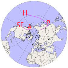
It's hard for most people to imagine how close Anchorage is to Korea.  When Korean Air flew non-stop, we could get to Seoul in about seven hours.   Flying over the pole works.  We got to Paris last summer in about ten hours (not counting the time on the ground in Iceland).  That's about how long it would take to fly to New York if there were non-stop flights.

It helps to see these distances on a polar map.  Don't mind my messy lines.


Original Polar Map from Winwaed blog

Pyongyang to Anchorage = 3564 air miles
Pyongyang to Honolulu = 4597 air miles
Pyongyang to San Francisco - 5597 miles


Does my title question strike you as alarmist?  I'm sure that a lot of people in Houston are asking themselves if they should have heeded warnings, warnings that said climate change was making more forceful storms and that Houston's development in open areas needed to drain water in a flood plain would result in disastrous floods.

With the news this weekend of a much larger nuclear weapon than previously tested in North Korea, I think it's reasonable to ask this question about staying or moving.  So let's look at the key questions:

1.  Can and will North Korea build a bomb and intercontinental ballistic missiles capable of reaching Anchorage in the next year or two?  It's looking increasingly possible.

2.  If they can, would they use them to target the US?  Americans have a highly distorted view of the world.  In our minds, its ok to have troops and ships and planes stationed all over the world, yet we got crazy when the Russians tried to put missiles into Cuba in 1962.  Other countries also don't like 'enemy' troops so close by.  We've had troops in South Korea since we fought North Korea in the 1950s.  Of course the North feels threatened.  We like to joke about how crazy the North Korean leadership is (and it's certainly unique in the world today), but according to a Heritage  Index of 2017 US Military Strength the US has
"some 54,000 military personnel Department of Defense civilian employees in Japan" and  "maintains some 28,500 troops in Korea." 
Yet any attack on the US by North Korea, let alone a nuclear attack, would be suicide.  But if they thought we were attacking them, I don't doubt that they would attack us - if they could - as well as the much more populated nearby South Korean target.  That 'mutual assured destruction' was supposed to be the deterrent during the Cold War.

3.  If they could and they would, would Anchorage be the target?  Hawaii probably has much more appeal.  There are more people in Honolulu and a large US military presence.  When the Japanese attacked Pearl Harbor, the US military presence in Alaska was tiny in comparison.  Seattle and San Francisco and Los Angeles are much better targets.  But Anchorage is closer.
Today Anchorage has a joint army/air force military base with a combined population of about 11,600.   The US tests anti-ballistic missiles from Kodiak, Alaska against potential attacks from North Korea which would make a tempting target as well.
The most compelling reason, in my mind, to attack Anchorage is that it is the closest US target, meaning the US defenses would have less time to respond.

4.  What could stop them?

  • Chinese and Russian influence on North Korea
  • Economic sanctions - these could make it impossible to complete their weapons, or it could just make them more desperate.
  • Conducting ourselves less threateningly - if Pyongyang thinks a US attack is imminent, if we could find a way to convince the that's not the case, it might work.  But if preparing for a US attack is simply a way to keep the North Korean population afraid of war and supportive of the government, it won't.  
  • Anti-ballistic missiles maybe.  They seem to have a spotty record with targets they knew were coming.  

So, is it time to look at real estate outside of Anchorage?  I'm sure few Alaskans are going to move at this point because of North Korea.  While Alaska did have a monster earthquake in 1964, relatively few people died and most people here now, weren't here then.  We feel safe.    Just as the people of Houston did a few months ago. Moving means disrupting our lives. But if the odds of an attack seem low, the odds of surviving a successful attack would be nil.  Only a tiny fraction of the people in Houston died.  That wouldn't be the case here.  

Thursday, March 16, 2017

Anchorage Assembly Race, District 6 (South Anchorage) Candidates

Sunday's (March 12, 2017) AFACT Assembly Candidates Forum was well run, well attended and gave me a good introduction to most of the assembly candidates.  As I started a post on this, it quickly became clear I ought to break this up into several different posts - starting with an intro page for each assembly district.  This is the last of the districts.  I'll try to get another post up about the forum next.

So, here's the District 6 (South Anchorage) map with a photo of the candidate who was there. (In this district, one of two.)

click on image to enlarge and focus
 

Albert Fogle (generic image) 
The other candidate, , was not at the forum so I have used this generic candidate photo.


Here are links for the two candidate websites:


Here's my posts for:
District 1 (downtown) candidates.
District 2 (Chugiak-Eagle River)
District 3 (West Anchorage)
District 4 (Midtown)
District 5 (East Anchorage)
District 6 (South Anchorage)

[Update 3/21/17:  Here's the sample ballot for District 6 voters.  Well, actually, some District 6 voters have two voters.  
If you live in Rainbow, Indian, Bird Creek, a section north of Girdwood outside the GVSA, and Portage, you also vote on adding Anchorage police service. Here's that ballot.
If you live in Girdwood, you have another ballot to annex some nearby parcels that are not in the GVSA.]

When I finish the posts for the other districts, then I'll do a post about the Sunday AFACT forum.

Monday, March 13, 2017

Anchorage Assembly Race, District 3 (West Anchorage) Candidates

Yesterday's (March 13, 2017) AFACT Assembly Candidates Forum was well run, well attended and gave me a good introduction to most of the assembly candidates.  As I started a post on this, it quickly became clear I ought to break this up into several different posts - starting with an intro page for each assembly district.


So, here's District 3 (West Anchorage)  Here's a map of the district with photos of the candidates who were there. 
click image to enlarge and focus

Placeholder for Tim Steele


The other District 3 candidate - incumbent Tim Steele - was not there.   Here's a generic candidate picture, based on pure imagination.


Here are links for the candidate websites:

Dave Nees
Tim Steele

Here are my posts for:
District 2 (Chugiak-Eagle River)
District 3 (West Anchorage)
District 4 (Midtown)
District 5 (East Anchorage)
District 6 (South Anchorage)

[Update 3/21/17:  Here's the sample ballot for District 3 voters.]

When I finish the posts for the other districts, then I'll do a post about the Sunday AFACT forum.  

Saturday, September 10, 2016

Articles of Interest - ISIS Recruits, Genes, Bias, Map Artist

There's way too much information for anyone to keep up with.  Here are some ideas worth considering.


Danes choose love over punishment to fight terrorists with some apparent success.
". . . France shut down mosques it suspected of harboring radicals. The U.K. declared citizens who had gone to help ISIS enemies of the state. . . But the Danish police officers took a different approach: They made it clear to citizens of Denmark who had traveled to Syria that they were welcome to come home, and when they did, they would receive help with going back to school, finding an apartment, meeting with a psychiatrist or a mentor, or whatever they needed to fully integrate back into society."


When a Person Is Neither XX nor XY: A Q&A with Geneticist Eric Vilain

People argue that the use of computers, human bias can be eliminated, but this piece shows that human bias can still be reflected in the programs they write.

"That has important applications. Any bias contained in word embeddings like those from Word2vec is automatically passed on in any application that exploits it. One example is the work using embeddings to improve Web search results. If the phrase “computer programmer” is more closely associated with men than women, then a search for the term “computer programmer CVs” might rank men more highly than women. “Word embeddings not only reflect stereotypes but can also amplify them,” say Bolukbasi and co."


Secrets are not a secret anymore if more than one person knows...
“A real secret is something which only one person knows.” ― Idries Shah, Reflections

There are no secrets that time does not reveal. Jean Racine If you reveal your secrets to the wind, you should not blame the wind for revealing them to the trees. Khalil Gibran
An argument against having backdoor keys to break into phones.


Rubric Memo  -  A spoof on academic memos and the use of rubrics.
"We refer to this rubric as Project 3.5.1, which you will recognize as a series of numbers. By entering data about your courses into this rubric, you help us to improve education for all our students, to whom we have also assigned numbers. We have also assigned you a number based on an Enigma-encrypted combination of the street address of your childhood home and your ATM PIN code, which we hacked (please see attachment 7)."


Map Maker Artist Perfectionist 
"These days, almost all the data cartographers use is provided by the government and is freely available in the public domain. Anybody can download databases of highways, airports, and cities, and then slap a crude map together with the aid of a plotter. What separates a great map from a terrible one is choosing which data to use and how best to present it."

Wednesday, June 17, 2015

Reasons Why Alaska Legislature Republican Majority Leaders Hate Governor Walker

Alaska's Republican majority leaders have done their best to show their disdain for Governor Walker.  They refused to meet in Juneau despite his calling for the special session to be there.  They've said no to most of what he wants to do.  Why all this antipathy?  

I'm sure readers will think of a lot more reasons, but here are a few I can think of:

  1.   He left the Republicans and became an Independent
  2.   This let him by-pass the Republican primary
  3.   He joined with the Democratic gubernatorial candidate as his Lt. Gov partner
  4.   He won the election beating their oil company loyalist sitting governor Parnell
  5.   He's acts like an adult
  6.   He knows how to think for himself
  7.   He understands the economics of Medicaid expansion and thus supports it rather than stick to Republican ideological anti-Obamaism
But I think the most important issue for the Republicans is the fact that

8.  the next governor will be able to appoint two members to the 2020 Alaska Redistricting Board. 

They're doing everything they can to make him look bad, hoping he won't get reelected.  If the letters to the editor are any indication, they're making themselves look bad instead.  And Walker, as I mentioned above, is the one who looks like an adult in all this. 

Speaking of redistricting, it's not too early to start thinking about the next Board and how it will work.  By leaving all the decisions about technology to the Board, things get rather late to do the best job of surveying the technology available.  Mapping technology is getting much more sophisticated and much easier to use.  By the 2020 round there should be better technology to create the initial maps and the public should have access to play with the maps and come up with better alternatives.  Just something to think about. 

Saturday, April 25, 2015

Alaska Press Club Conference Ends Saturday Sunset


Susitna was silhouetted by the sunset as we left the Awards Dinner for the Press Club.  Steve Heimel got honored with a first amendment award and gave a passionate speech about the need to fight constantly to keep the first amendment.


Vera Starbard, and her husband Joe, two of our table mates, took home several awards for First Alaskans Magazine.  She's also written a play - Our Voices Will Be Heard -that's scheduled to be performed in Anchorage next January.  Lisa Phu and Matt Miller from KTOO were also at our table and also got awards. 


There's so much to write about the conference.  I have lots of notes, but didn't have time to do anything with them.  I went to four sessions on data journalism - using data sets to find trends and ways to graphically display them.


I'll try to write more about them, but meanwhile, here's a picture of Andy Eschbacher during his presentation on data mapping.  He works for CartoDB with offices in Madrid and Brooklyn.  They have software for combining data and maps, including a free level, and I intend to try my hand at their tutorials to see if I can get to a point where I can use this.


And then there's the log guy who I met at the last session.  He's from Kentucky, I think he said, visiting a friend in Alaska, and he carries this log around a lot.  There was something about being good when he works with kids.  (I can hear some of the presenters asking, "But where's the rest of the story, you're leaving us hanging  . ."  I think some mysteries are good, and all the readers can create their own story about the log guy. 


What Do I Know?  got some recognition at the dinner - two second places.  One for Best Current Events/News Blog and and another for Best Commentary Blog.  There was also a third place in Arts Reporting Print/Online small organization.  That was for a my Q&A page for the Anchorage International Film Festival.      It's nice to know that others think this little blog is doing some things right.  Thank you Alaska Press Club. 

The Press Club's Facebook page says all the rewards will be posted at their website on Monday.  And the Twitter hashtag #AlaskaPressClub already has a lot of pictures of awards up.
[Update May 3:  Here's the whole spreadsheet of the winners at the Alaska Press Club site]


Thursday, September 25, 2014

The Story Of Mankind: History Of The Middle East In 300 Words


click to enlarge the images
"The story of Mesopotamia is one of endless warfare and conquest. . .

"In the fortieth century before our era, the Sumerians had entered Mesopotamia.  They were soon afterwards overpowered by the Akkadians . . . A thousand years later, the Akkadians were forced to submit to the rule of the Amorites, another Semite desert tribe whose great
Damascus, the capital of modern Syria, is in the middle

King Hammurabi built himself a magnificent palace in the holy city of Babylon and who gave his people a set of laws which made the Babylonian state the best administered empire of the ancient world.  Next the Hittites whom you will also meet in the Old Testament, overran the Fertile Valley and destroyed what they could not carry away.  They in turn were vanquished by the followers of the great desert god, Ashur, who called themselves Assyrians and made the city of Nineveh the center of a vast and terrible empire which conquered all of western Asia and Egypt and gathered taxes from countless subject races until the end of the seventh century before the birth of Christ when the Chaldeans, also a Semitic tribe, re-established Babylon and made that city the most important capital of that day.  Nebuchadnezzar, the best known of their kings, encouraged the study of science and our modern knowledge of astronomy and mathematics is all based on certain first principles which were discovered by the Chaldeans.  In the year 538 B.C. a crude tribe of Persian shepherds invaded this old land and overthrew the empire of the Chaldeans.  Two hundred years later, they in turn were overthown by Alexander the Great, who turned the Fertile Valley, the old melting-pot of so many Semitic races, into a Greek province.  Next came the Romans and after the Romans, the Turks, and Mesopotamia, the second centre of the world's civilization, became a vast wilderness where huge mounds of earth told a story of ancient glory." (pp. 84-87)

This is from Henrik Van Loon's The Story of Mankind, the first book to win the Newbery Prize for outstanding contribution to children's literature in 1922.  It has over 500 pages and as you can tell, it's a little dated and Eurocentric.  The first index reference to China, for example, isn't until World War II. 

This is a book I got as a kid.  I don't remember how much of it I actually finished.  But with my son here looking through the closets and garage for stuff he's left behind, this book showed up. 

What strikes me is the much larger context it gives the events in the Middle East today.

Like, "In the fortieth century before our era."  Forty centuries.  That's 4,000 years.  Add two thousand years since the birth of Christ and we're talking about 6000 years.  Since the so called 'first Iraq war' in 1991, the US has been involved in Iraq and Afghanistan about 23 years out of that 6000.

Despite those who believe in American exceptionalism,  we're still a relatively young nation, and throughout history there have been many powerful nations that have ruled large portions of the world, and then have faded into obscurity.  I thought I'd put up these maps to remind folks of the geography - I have a modern map with the countries that border Syria here - and also to remind us that the limits of our knowledge plus our biases cause us to believe our version of Truth which inevitably will change as time goes on.  That's not a bad thing.  In fact it's inevitable.  But we're wiser and probably more effective human beings if we remember that and leave a keyhole of doubt in all our certainties. 


The Story of Mankind, it seems, was made into a terrible film in 1957 - the last film to have three Marx Brothers.  You can learn more about the film (and see a couple of clips) here.