Showing posts with label Turnagain Arm. Show all posts

Sunday, September 18, 2011

Why I Live Here - Fall Walk On Beach - Plus a Bear, a Dog, Swans, Mud, and Fiber Optic Cable

In 30 years, my definition of a beach has stretched beyond sand and palm trees.  There's a spot of rocky beach and mudflats that we like on days with sun and no wind.  Today qualified.

Looking South Down Turnagain Arm


Looking North
First we stopped where cars were parked along the side of the road.  Not unusual when the Dall Sheep are around.  But the sheep we saw was black and looked a lot more like a bear. 


He's up there top, left of the middle.  Ignoring all the people and stopped cars below.  We went years and years seeing less than a handful of bears in the Anchorage area.  This was my fifth bear this summer in Anchorage.  (Anchorage stretches a long way south along Turnagain Arm.)


I made a self-portrait out of Turnagain mud and rocks.

One train went by headed north and another south while we were on the beach.  We walked  back on the tracks, which was a lot easier than the rocky beach.  We kept a close lookout for trains, but we didn't see another one until we were 15 minutes down the road in the car.


I found a long description of this cable line on a 2006 post at Diesel Generator:

"Fiber optics involves the transmission of laser signals along glass fibers at the speed of light. In the case of the ANC/WCIC cables from Whittier, communications equipment connected to the fibers enables signals to be transmitted at 10 billion bits per second. These 10 billion bits per second will encompass voice, data, and Internet traffic, at a rate equivalent to 128,000 simultaneous telephone calls.
"In some respects, the companies putting up the facilities are competitors. On one side of the railroad tracks on the upper side of town, a facility is being installed by General Communications, Inc. (GCI). GCI will service submarine cables laid to Valdez, Juneau and Seattle. WCI Cable, Inc. (WCICI), will operate submarine cables laid to Valdez, Juneau and 2000 miles on the North Pacific sea bottom to Portland and Seattle via a "landing site" at Tillamook, Oregon. . .
"Worldnet Communications, Inc. Alaska Fiber Star (AFS), WCI Cable, Inc., and Alaska Northstar Communications (ANC) are companion units in a family of communications companies that are owned by an Australian insurance and investment company, AMP Ltd.
An existing AFS "backbone" - terminology for the routing of a fiber optics system - emanates from Anchorage and runs to Fairbanks with ADMs (add/drop multiplexers) at Wasilla, Talkeetna, Cantwell, Healey, Clear, Nenana and Fairbanks. At these sites, traffic can be added to or dropped from the backbone system to provide communications access to local carriers. The fiber optic signals are also regenerated and passed on to the next site. Presently these stations are sited about every 60 miles.

From the Anchorage NOCC, the backbone runs south along the Alaska Railroad route to Whittier. A 100-mile submarine cable runs to Valdez.
 The friend enjoying the sun and sea with us said that WCI no longer exists.  While trying to check that out online, I found a 2002 Bankruptcy Court opinion (pdf) regarding the fee they paid for this cable to the Alaska Railroad:
"The WCI Group has installed, maintains and uses its fiber 26 optic cable between Anchorage and Eielson Air Force Base (the “Northern Route”) and between Anchorage and Whittier (the “Southern Route”) in Alaska pursuant to two “Transportation Corridor Permits”  (the “Permits”) with the Alaska Railroad Corporation, which owns the rights of way. Under the Permits, the fee for the WCI Group’s use of the Northern Route right of way is $150,220 per month, or a total of $1,802,640 per year, and the fee for the WCI Group’s use of the Southern Route right of way is $297,320 per year, payable in quarterly installments of $74,330. The WCI Group’s payment obligations under the Permits represent a heavy financial burden that the WCI Group would like to lessen."


But we weren't thinking about any of this as we walked.  Rather we were absorbed in all the colors.  Like this fireweed.


At the parking lot, I found an answer to a question in yesterday's post.  Yes, there is a dog.


This calm reflection of sky and fall colors at Potter Marsh belies all the cars and highway noise as people returning to Anchorage slowed down and stopped to watch the seven trumpeter swans getting ready to head further south for the winter.

Thursday, June 09, 2011

A Better Map of Anchorage

As we flew out of Anchorage today to go to an important graduation in Seattle, the plane took off to the south rather than the usual northern loop. And I saw a much better view of Anchorage than what I've been seeing lately. Here's today's view.


Here's the view of Anchorage I've gotten more familiar with in the last 3 months:


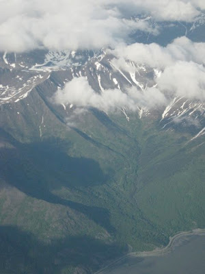
Turnagain Arm was pretty spectacular.


Following the Seward Highway south.


Bird Point
Here's a link to the State's webcam shot there a little after this picture was taken.

Note:  In case it wasn't obvious, there was a bit of photoshop tampering with the top picture to merge three different pictures together and to acknowledge a bit that they were from somewhat different angles.

Tuesday, October 19, 2010

Off To Portage Pass Trail

With Tony Hopfinger free on bail  and my audio/visual of the Joe Miller's East German border comments posted AND the sun showing through the window, we thought we should get out of town a bit.  We heard through family connections of a great spot - a place we'd never been or even knew about, so we headed south down the Seward Highway toward Portage.  We'd checked on the tunnel schedule (to Whittier on the half hour and back on the hour, with a 15 minute window in each direction.) 


We headed down the Seward Highway along Turnagain Arm.


Then the cutoff to Portage Glacier.


Getting near the tunnel to Whittier and there's still plenty of blue sky.


Portage Pass Trailhead

As you come out of the tunnel toward 'downtown' Whittier, there's a road to your right at the end of the airport runway (on your left).  That goes to the trailhead.

We encountered some berry colored bear scat right away.


It's a 750 foot climb.  Not a lot compared to a lot of the hikes in Southcentral.  But it pretty much just keeps going up.  I figure that's like climbing 75 stories.  But the view of Prince William Sound got better and better, even on this now, mostly cloudy day.


Now we're almost at the viewpoint.


There were three guys and two dogs there ahead of us.


Here's the view from the viewpoint.  And the photo is pretty lame.  Between the clouds, the white of the glacier, and shooting into the sun, it was hard to get decent lighting.  The view was spectacular.  And what you see is not what you see from the visitors' center.  This part of the glacier is still down in the water.

 Here we are, trying the rocks out.


And then back down.  You can also hike down to 
the lake in the picture, but we came back.  

Beautiful Downtown Whittier.  Is this where Nixon went to school?


We got back to the tunnel just in time for the 4 o'clock opening.  According to the Department of Transportation, this is the longest Railroad/Highway tunnel in North America.


Then back on the road headed north to Anchorage.


We passed several sets of swans before we got home.

Wednesday, August 26, 2009

Ride To Bird Creek

Sometimes it's easy to get stuck in town, especially when you try to use the bike instead of the car. But this evening we decided to take a 'short trip to Alaska,' so we drove out of Anchorage down to Bird Creek. And here is where the rain had been hiding. But soon there was a faint rainbow over the mudflats.


It had been threatening to rain all day, but the sun managed to find the holes in the clouds most of the time. But down here it let loose. There's a hint of a rainbow in this picture of Turnagain Arm.


Here's a picture of the mudflats.


To make more sense out of the previous picture, here it is with the mountains to give it some context.


Mudflats at the mouth of birdcreek, with a run of salmon coming in.


There's a street off the Seward Highway at Bird Creek with this street sign. Problem is, the jay
is named after the German naturalist Georg Wilhelm Steller who discovered them in 1741 (Evans 1986).(wikipedia
(from Wikipedia)
On the one hand you could say just leave it. But it has nothing to do with the stars, it's about Georg Wilhelm Steller. If you leave it, people will see it and think it should be spelled this way.


It smelled pretty bad here as there was a fair amount of rotting salmon waiting for the gulls to clean them up.


Now we're on the boardwalk at Potter Marsh.

We saw the swans as we drove along the Marsh. The belted kingfisher (sorry, but real birders will recognize it from this shot) was there briefly. The bald eagle's been there all summer at a next. I took this through someone's spotting scope.

It really wasn't this dark, but my choice was to make the foreground dark or wipe out the sky.