Showing posts with label snow. Show all posts

Tuesday, April 16, 2019

Campbell Creek - Still Some Snow

Biked over to Campbell Creek yesterday to see if the snow was gone from the trail as it is from the Chester Creek trail from UAA to Goose Lake and on around to Alaska Native Medical Health Consortium (ANMHC).  It's close, but there are still snowy/icy/slushy spots like this one.


I made it through on several of these patches, but decided I'll wait another week to see if my regular run up to Campbell Airstrip is ice free.  But the views of the creek from the various bridges is, as always, wonderful.


Monday, March 25, 2019

Nah. . . Forget Politics For Now - Anchorage Trails Along Streets Are Snow And Ice Free!

So many things nationally and locally to ponder, but I checked out the sidewalk/trails along a loop from Tudor, Elmore, Dowling, and Lake Otis back to Tudor (that being my warm up run until the the greenbelt trails are clear in the spring) and things were snow and ice free.

I actually didn't take any pictures of trail, except for this one on a bridge on Elmore.


I checked on last year's posts and this one from March 22 is the first bike ride I did last year.  I wrote the

 "for the most part the trail was ice free.  There'd been one spot where a thick chunk was floating over a puddle, but there was a bit of room to go around it.  But then, almost home, I got to this hard packed ice near Providence."
As I recall, there were places where there were big puddles and snow was melting from where it was piled next to the trail.  And the bridge over Campbell Creek (at Lake Otis) still had snow on it.

This year the trail was basically like in the picture.  There were wet areas, but no ice or snow that I was riding through.  There's  a picture in last year's post of trail full of ice and snow on both sides near Providence.  But this time I went in the other direction so I didn't go by there at all.  But I suspect it's clear too.

Anyway, here's Campbell Creek, north fork, from the bridge at Elmore.


And a little further down the road, the south fork of Campbell Creek.


Here's what this spot looked like on March 22, 2019 - with blue sky and sunshine.


Then west on Dowling and north on Lake Otis - here I am at Campbell Creek again, but here both the north and south forks have already converged into one creek.


It seemed a bit early to be so snow and ice free this year, even before I check last year's post.  But I also saw a tweet:


I think this would be clearer if it said "we've had 13 fewer days that dipped below 40˚ than the year with the next fewest days"  it would be clearer.

Tuesday, March 19, 2019

Break Up

Ice shelf at end of driveway last week
The temperature has been well above normal - sometimes the lows being higher than the normal high - but it's also been cloudy and grim out.  The warm days have been causing snow to melt and then freeze up at night.  The city plowed the street, but never cleared the berm they left.  It's melted a little each night into a shelf of ice that's 4 inches or more in places.

I've been going out and chopping ice and making a channel.  The picture on the left was a week ago.


This morning there was a powdering of snow on the ground, but from the dentist's chair, I could see sunshine to the south.


And this afternoon, the sun had made it into town.  (Of course the sun was there all along.  It's just the clouds cleared, but it really did feel like the sun had come.)

And with the sun beating down, the shelf was getting slushy and the ice and snow in the part of the streets the cars crunch was mostly gone.


Here you can the melting remnant of the berm.  It's hasn't been snow for a while.  Rather it's a hard crusty icy wall.  I went to the corner to see if I could shovel out the drain, but it was not going to happen.


But I was able to play with the ice chopper at the end of the driveway.  With the warmth and the sun, the shelf was changing composition.  And parts broke off with a single chop.  And then I had lots of ice to clear away.  I know that all this will go on its own, but if I gain a week that's good enough for me.  And I get some exercise.  Out in the sun.


It's a great time of the year.  We're a day from the equinox when every part of the world has the same amount of light.  After that, those places further north get more light.  And around 60˚ north, we gain almost 6 minutes a day now.  And there should be close to a full moon tonight as well.

There were even patches of ground showing up as snow melted and evaporated.


I think the green is just some grass that made it through the winter under the snow.  The berries are from the mountain ash tree that the bohemian waxwings didn't find.

Saturday, February 09, 2019

Deicing As We Leave Seattle's Snow For San Francisco's Rain

There was about 6 or 7 inches of snow this morning when we headed to Seatac.  Someone had plowed a snowy/icy path along the sidewalk and the walk back to the airport wasn't too bad.

A lot of flights had been cancelled, but our was scheduled to leave on time.  But then they had to deice.  I had a pretty good view.  So here's a minimally edited video of part of the process happening outside my window.  (As I was editing, I realized that often my purpose is not to just cut to the most dramatic few seconds here and there.  Rather I figure someone who knows a lot more than I about deicing (that would be anyone who knows anything at all about deicing) might get more out of my leaving most of the footage in.)


From Wikipedia:
On the ground, when there are freezing conditions and precipitation, de-icing an aircraft is crucial. Frozen contaminants cause critical control surfaces to be rough and uneven, disrupting smooth air flow and greatly degrading the ability of the wing to generate lift, and increasing drag. This situation can cause a crash. If large pieces of ice separate when the aircraft is in motion, they can be ingested in engines or hit propellers and cause catastrophic failure. Frozen contaminants can jam control surfaces, preventing them from moving properly. Because of this potentially severe consequence, de-icing is performed at airports where temperatures are likely to be around 0 °C (32 °F). 
In flight, droplets of supercooled water often exist in stratiform and cumulus clouds. They form into ice when they are struck by the wings of passing airplanes and abruptly crystallize. This disrupts airflow over the wing, reducing lift, so aircraft that are expected to fly in such conditions are equipped with a de-icing system.
De-icing techniques are also employed to ensure that engine inlets and various sensors on the outside of the aircraft are clear of ice or snow. 
Chemical de-icing[edit]
De-icing fluids consisting of propylene glycol (PG) and additives are widely used by airlines for de-icing aircraft.[2]:43 Ethylene glycol (EG) fluids are still in use for aircraft de-icing in some parts of the world because it has a lower operational use temperature (LOUT) than PG. However, PG is more common because it is less toxic than ethylene glycol.[3]:2–29

Alaska Airlines' blog also has a post on deicing.  

When we took off, the wing was green.  It was its normal color when we landed in San Francisco where the sun was out as we landed.  But when we got out the BART station downtown, it was raining.  But when i'm with my grandkids, the sun is always shining.


I'd also like to point to an article in the Alaska Airlines Magazine for February 2019.  It was about how CEO Brad Tilden spent a week shadowing employees in Alaska.  Yes, putting it in the magazine is hype, but the fact that he was on the ground (and in the air) with employees doing their jobs with them says good things about him and the airline.  He wasn't just in Anchorage, he also flew out to Dutch Harbor on PenAir.  And in Anchorage he did a night shift.  You can see the piece here.

Friday, February 08, 2019

Seattle Readies For Snow Storm, We Decide To Get Closer To Airport

We have tickets for tomorrow back to San Francisco for more grandkid duty.  But our daughter warned us a storm was coming.

..WINTER STORM WARNING REMAINS IN EFFECT FROM NOON TODAY TO 4 PMPST SATURDAY...
* WHAT...Heavy snow expected. Total snow accumulations of 4 to 6inches expected. Local snowfall accumulations of 8 inches. Northto northeast winds will increase late tonight and Saturday to 15to 30 mph with some local gusts to 45 mph. The wind will likelyreduce visibility at times due to blowing snow, especially nearshorelines of the inland waters.
* WHERE...Portions of northwest and west central Washington,including Seattle, Everett, Tacoma, Bremerton, Bellevue, NorthBend, Redmond, Kent, Port Angeles, Sequim, Oak Harbor, and MountVernon.
* WHEN...From Noon today to 4 PM PST Saturday. The heaviestsnowfall accumulations for most of the area will occur between 3PM this afternoon and 10 PM this evening.
* ADDITIONAL DETAILS...A period of 2 inch per hour snowfallaccumulations is likely during todays late afternoon and eveningcommute in the Tacoma, Everett, Seattle, and Bremerton area.Travel is likely to become very difficult. Areas of blowing snowcould contribute to reduced visibility late tonight intoSaturday.

The island is a 35 minute ferry ride from downtown Seattle.  Then it's a short walk to the train, and about 40 more minutes to the airport.  And when storms hit the island, trees fall onto power lines and people lose power for days sometimes.  And they said the ferry can't dock if there's no power.

But the ferry only comes once an hour so last time we had to get the 7:05am ferry to get to a 10:45am flight.  (The 7:55am ferry probably would have gotten us there on time, but if anything went wrong on the way we'd have missed our flight.)

Snow falling as we depart ferry,  barely see Seattle buildings
So we decided we should get a room near the airport for tonight.  But that was easier said than done.  Everything in the SEATAC area was full.  I finally got a room at Motel 6.  We could check in at 3pm.

Last night the snow wasn't going to start for real until about 3pm so we decided on the 1:15pm ferry.  But we decided if we were packed we could go for the 12:20 ferry.  And then we learned the advisory had been moved up to snow beginning at noon.  So as we were walking to the ferry, the first flakes began.


We walked up to the Link (light rail) station past Pioneer Square.  If you click on these pics you can see the snow.  They were big flake and coming down seriously.

As Alaskans we take all this snow preparation as a little strange, but they don't have the plowing equipment and they don't have snow tires or studs, and there are lots of hills.


The train station was a surprise.  It looked like everyone had decided to take the afternoon off to get home before the snow got bad.  The buses and trains were packed.  After not being able to get on the first two trains, we got a little pushier for the third.

This was after things got a little better.


By the time we got to the SeaTac station, the snow was sticking on the side streets and sidewalk, but
it was less than a mile walk so we enjoyed the snow.  We've reduced our luggage to one carryon and two backpacks.  (We've heard about but haven't watched Marie Kondo.  We've generally traveled light enough so we can walk with our stuff if we have to, but for this week in San Francisco we've rethought anything that had any weight.  Here's the view from our no frills hotel room - but there is heat, to compensate for the gaps in the door frame.


Saturday, October 27, 2018

A Ride At Sunset While I Sort Out Friday's Court Notes

I've been working on a post about Friday's court session, but it's not done.  When you read an article in the paper, remember that someone had to go out an gather the news, then they had to make sense of it, then write so it's interesting, but not pandering.  It's not that I haven't been working on it, it's just not done.  An advantage I have over reporters - no deadline, though I know there will be more Monday, and I have some background stuff I want to get up too.

In the meantime, the sun was out this afternoon and so I got out the bike and went on one of my regular rides - NOT downtown.  It's still beautiful.  Though late October with no snow in town at all, and there hasn't been any, is strange.  It was 42˚F (5.5˚C) when I took off at 5:30pm.


On the Campbell Creek Trail just east of Elmore Road.

Flattop on the right.  I'm pretty sure the snoyw peak is O'Malley 


I looked at some older blog posts for late October and going back to 2006, there really isn't any snow.  We're all talking about the strange October, but it's about how warm it is, not, as I'm reminded by my old pictures, how little snow there is.  So far there was one day this week when there was even frost on car windshields.  But it wasn't on the grass.  I think it was rain hitting the cold glass.

Monday, May 07, 2018

Getting A Handle on Denali National Park's Vast Expanses

We're back as of Sunday afternoon.  Our upstairs ceiling popcorn is gone and a new ceiling in place.  Everything is still shoved into spaces to allow for painting the ceiling and walls.

Saturday at Denali was Denaliesque.  I recently saw a Mongolian movie and thought, wow, those huge vistas remind me of Denali National Park.  The sun was out most of the time, the clouds here and there not threatening rain or snow.  The (still) white vistas - humans generally just don't experience stuff like this.  You see for miles and miles unpopulated land surrounded by mountains.  With the late snow everywhere it was almost too much.  After you enter the park, about four miles in, you're past all the park buildings - visitor center, camping and touring building, education center, housing for workers, sled dog kennels, and then there's just one road that goes for 90 miles.

Only 30 miles are open now (until buses start May 20), so what we saw is that part of the land you can see from the road in the first 30 miles.  There are a few structures inside the park - at campgrounds basically and lots of restrooms at the bus stops.  After May 20, you get past the first 3 miles or so only on the buses.  Or if you have a camping spot at Teklanika.  All the other camping spots are tent only and you get there by bus.  And there's a big visitor center at about mile 60.


The picture above is the road into the park (though we were driving back to the campgrounds at the entrance when I took this.)  You can tell we're still within the first 15 miles of the road because it's paved.  We're looking east.

And here's a panorama view - I've photoshopped three pictures together.  You see about 20-30 miles into the distance and probably 30 or so miles across from left to right.  If you click on the picture you can see it bigger. (Large vertical images work great here, but horizontal ones don't.)


Just think about what a 25 by 30 mile area in your city would encompass.   In LA that would be approximately from Santa Monica to East LA and from Beverly Hills to Palos Verdes.   It's most of the LA basin with one road and for 85 miles of that road just a few structures and outhouses.   Get a map online of your location.  Seeing such vast distances with nothing but one road and just a few structures stretched out of 90 miles on the road is always mind-boggling, even after 40 years.

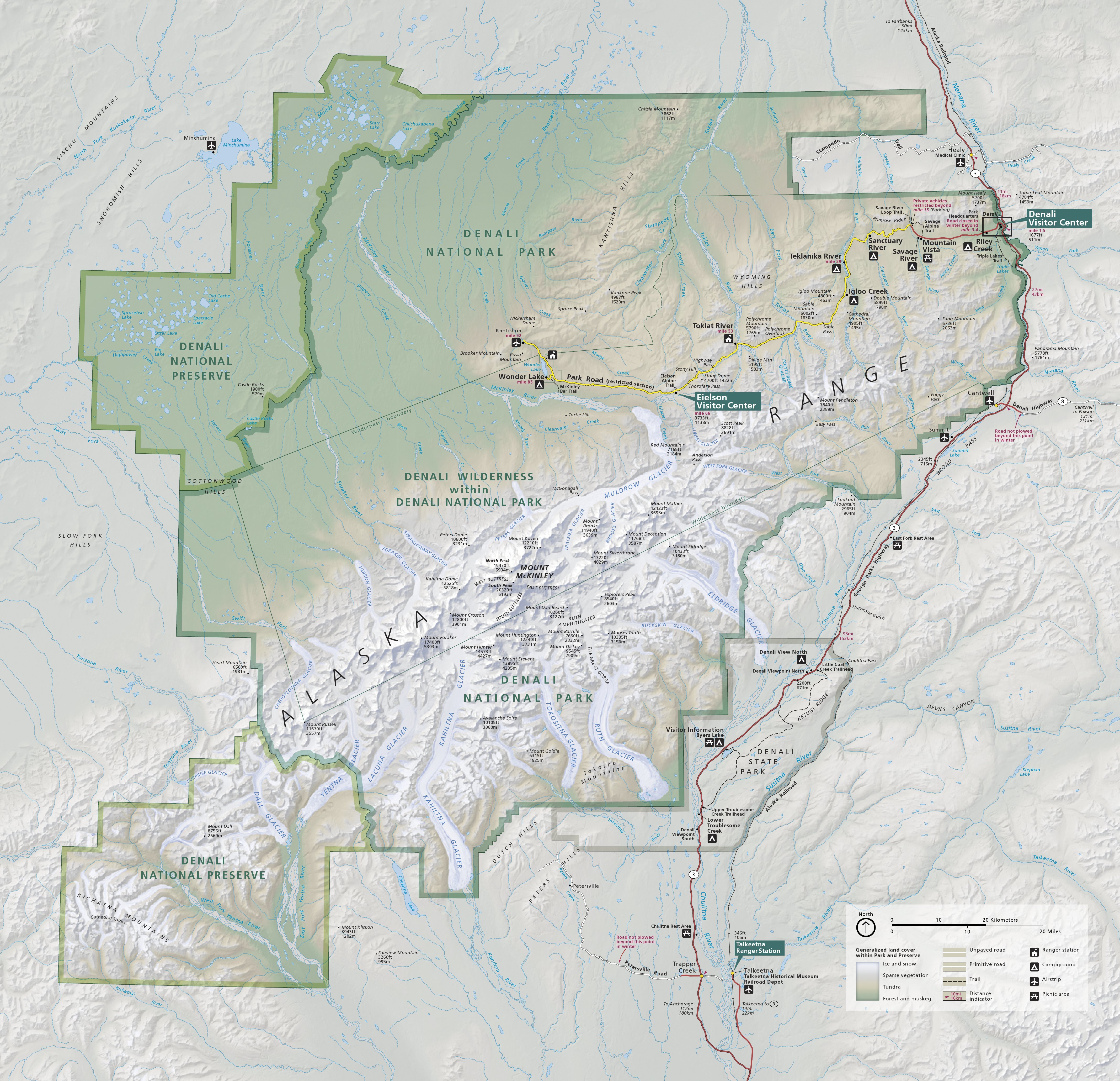
And here's a map of Denali National Park and Preserve to get all this into even more perspective.

Original map from National Parks Maps  - This map is fairly large, but at the link it's much bigger

The entrance to the park is to the east where the little black rectangle is to the right of the red line. The first part of the road - brown on the original map here - is the 12 paved miles.  It ends at the red #1 on the map.  (I added the red because the yellow line is harder to see and to show you how far the road was open.)  #1 is where Savage River is, where we snowshoed on Thursday.  I didn't mention it in that post, but it was two years ago when we were there at the same time a young summer Park employee, Michael Purdy, had fallen and died and had not yet been found.  I wrote about that here.  A Park employee told me that his sister was in the park a week or two ago for the anniversary.  You can also see how different the trail looked in late April 2016 compared to early May 2018.
#2 is about where I took the panorama above from.
The Black Bear Paw is Teklanika Campground - the road is closed about a mile past there for now, though beyond it you can walk or bike.
#3 is Eilson Visitor Center (above the 3) - about 60 miles into the park with good views of Denali on clear days.
#4 is Wonder Lake campground, the end of the 90 mile road into the park.
#5 is the North Peak of Denali - the tallest mountain in North America at 20,310 feet (6,140m)

So what we saw last week is only 1/3 of the road in the park.  The panorama is of just one tiny part of the park.  The vast majority of the park has no structures at all.  And the views further in are even more expansive.  Even if you don't see any animals (not likely) or the mountain itself (much more likely), the landscape itself is worth the trip.

Looking through the trees across to a small mountain off in the distance.


Here you can see the slope of the land.  I took this from the road.  J is walking up the road in her red coat.  Since walking on the snow, even with snowshoes, is a challenge, we took turns walking along the road with the other waiting up ahead in the car.  You see much more on foot than in the car.


Here's an area where the snow had an icy glaze.  But if you tried to walk on it, you break right through the ice.


This is just past the gate that closes off the road at the Teklanika rest area.  I'm looking down at the Teklanika River, which at this point is mostly covered with snow still, just those few squiggly pieces of open water.  If you look closely you can see the bridge in the lower right corner.


And below you can see some of those squiggly spans of water from the bridge.


It was a beautiful day - I know that's relative.  The sun was out and the sky was mostly blue.  The temperature was in the 40's but there was a brisk wind in most places and especially on this bridge.    It was also a Saturday so there were a fair number of people who driven to the Park for the weekend from Anchorage and Fairbanks.

This post has taken a direction of its own - the vastness of the park - so I'll save some of the people   and critters we encountered for another post.

Friday, May 04, 2018

Moose's Teeth and Denali Patterns

I read in my cloud  spotter's guide yesterday that Alfred Stieglitz was the first professional photographer to take pictures of clouds, not just as part of a landscape, but as abstract art.  I guess that encouraged me to follow my druthers as we drove through the park today.  Today's clouds, for the most part, were one mass of grayish haze that the sun tried to burn through now and then, but that also included intermittent rain and snow.   This first one is the mountain above Savage River.


Another snowy landscape.


Snow/Ice on the side of the road.


More formations in ice and snow and dirt as the plowed snow on the side of the road melts and sublimates.

Rocks below the ripples of Sanctuary River from the bridge.


OK, time to get more representational.

A view from the road.


Another view from the road, in an area that had less snow cover.


A magpie flies across Sanctuary River.  At this point a car stopped and a woman asked if anything was moving.  I said, "Just a magpie and the water."  She said, "I love the magpies."  I said, "I see them at home everyday so they aren't that special."  She said she was from North Carolina so she never sees them."  "You're right," I said.  "They are really beautiful birds."  And they are with their striking black and white patterns and their dark colors that turn green and blue in the right light.


But here are much better magpie pics from  my front steps and here in my back yard.  The magpie made it across the river.  A number of years ago my daughter and I watched, at this same spot, a mother moose with a very young calf cross the river.  But the calf couldn't make it up the snow bank on the other side.  The mom tried to push it up, but after a while it got tired and the current carried if off down the river.  It was real life nature.  The mom climbed the bank and wandered off.  No one to to comfort her and I know she had to have feelings about this.  But someone down the river was in for a tasty treat.  The natural world is harsh, which  is why civilization, in its best meaning, is important and worth striving to keep alive and improving.


And while I was hoping to see some caribou today, again we only saw moose, which we can see in our on front yard.   But again, they are still magnificent and fascinating to watch.  Here's last year's calf (I think).

And her mom.  I've labeled this picture "Moose's Teeth" which has a little more meaning for Anchorage visitors.  Moose's Tooth is the most popular place for pizza and beer in Anchorage and also the name of a  peak in the Alaska Range.  She was with the calf eating on the side of the road just a mile or two from the visitor's center.  The elevation is lower here and there isn't as much snow and the vegetation is a little closer to greening.


Thursday, May 03, 2018

Quick Denali Pics

I'm sitting outside the closed visitor center at about 8pm to get the wifi.  It's in the 30s so I'm just going to put up some pictures without much conversation.  But I will say there's more snow than we've ever seen here, but the roads are great and we borrowed some snow shoes at the visitors center and I hiked a very windy mile with the snowshoes along Savage River and back.  Lots of rugged fun.


This was still about 40 miles from Denali National Park.


Here's the trail.  Well it's covered with snow, but you can faintly see some snow shoe tracks of the last person, but they're being covered quickly.

Snow shoes aren't the tennis racket kind of things of yesteryear.  These worked well, but you use different muscles and the wind was pushing really hard the whole way.  In my face on the way back.


 Much of Savage River along the trail is still covered with snow, but parts were showing.


Here are my tracks, just after I walked there, but on the way back they were barely visible.  The wind was blowing the snow as you can sort of see in the pic below.


The brown across the snowed over river near the top left is the bridge.


Here's the trail going back.  You can sort of see my old tracks.


Not sure whose tracks these are.  Rabbit?


I'll check tomorrow.


Here's some glaciation on the other side of the river.


Here's a view looking toward the west and the mountain, except the clouds are hiding the mountain.


And this is where we parked, popped up the top, and cooked some dinner - why our VW camper has been such an important part of our lives all these years.  Where else can you get dinner with a view like this?


We didn't see a lot of wild life.  A bald eagle flew alongside the road on the way to the park, just above the trees.  I saw a small flock (10-15 birds) take off on the side of the road.  They were white and 'snow bunting' popped into my head, but I have to check.  I did see snow bunting in Wales, Alaska once.  Also three ptarmigan - all white.  I don't remember seeing them like that before.  Usually, they are shifting to their summer plumage so they are half white and half brown.  Or in the summer all brown.  And then this moose.

My fingers are getting cold, so good night to you all.