Showing posts with label sunset. Show all posts

Tuesday, January 27, 2015

Ballona Creek, Birds, Curves

Ballona Creek today is a body of water in a concrete embankment in Los Angeles that flows into Santa Monica Bay.  Wikipedia gives us these choice bits of history:

 Ballona Creek and Lagoon are named for the Ballona or Paseo de las Carretas land grant, dated November 27, 1839. The Machado and Talamantes families, co-grantees of the rancho, heralded from Baiona in northern Spain.[5][6
...At the time of Spanish settlement, the Los Angeles River turned to the west just south of present-day Bunker Hill, joining Ballona Creek just to the west of its current channel. However, during a major flood in 1825, the Los Angeles River's course changed to its present channel, and Ballona Creek became a completely distinct waterway. Much of the above-ground section of the creek was lined with concrete as part of the flood-control project undertaken by the United States Army Corps of Engineers following the Los Angeles Flood of 1938.[7]
Birds, well you know what birds are.

Curves is a tool in photo software like photoshop that does strange things to light and dark and colors.  I don't understand quite what it does and I tend to experiment.  I figure if I do this enough, I'll start to see patterns for how the images change.  You can see, if you check the link, that what people write is interesting, and I've done some minor adjustments like they talk about, but the color freak in me is much more interested in the extremes, as you'll see in a couple pictures below.

I'd note I've saved the most interesting pictures for the end on the grounds that my readers will be rewarded for at least scrolling through the pictures, even if they don't read any of the text.

Part of this experimenting results from leaving my bigger camera in Anchorage and having to do bird shots with the little one that doesn't do distance well.


This first one was not altered in photoshop or anywhere else.  This snowy egret was standing near the Lincoln Blvd. bridge and the sun on the green and yellow of the bridge just rippled in the water like this.  I did crop the picture, but that's not altering.  How you frame the picture in the camera is cropping.


There was a sun cracked and warped bird sign where I got off the creek (at Centinela) that listed some of the common birds at the creek.  You can see the sort of baked look of the sign and when I enlarged the row of birds I shot, they were getting fuzzy in a similar way.  I didn't do anything to these pictures except resize them and put them together.


Below starts the curves experiments, first with the brown pelican.  (This is my least favorite of the group.)   I cut out the pelican in a circle and then I applied the curves to the whole picture and put the pelican cut out on top.  In this series I've include some of the original picture in with the curved portions of the photo.


Here's what the curves chart looks like.  The grey, as I understand it. . . actually, I don't understand it, and I'll just let you look it up yourself.  You know that's not like me, but I've decided that I'm just going to have to learn this non-verbally, by experimenting.

The curves box starts with a line going diagonally from the lower left corner to the upper right corner. As you move that line around (this one is probably a bad example because most of the ones I've done are curved) you get different effects - changes in light and dark and in color.  It's good to use if part of the picture is too dark or too bright for the rest of the picture.  You can change the one part to work better with the other part.  In this case I made it more horizontal and vertical than curvy.


Next is the great blue heron.  (The bird sign only listed the great blue and when I checked on line, it matched pretty closely.)   In this shot, I first split it diagonally and the applied curves to the top part.


I'm calling this one Ballona Creek Bore Tide.  I don't know if that's what they call it here, but these waves came in all of a sudden and reminded me of the bore tide on Turnagain Arm.  Here, I curved the middle - and in this case it really had a functional purpose:  it emphasized the waves and ripples I was trying to show.  I left a bit of the original as a frame.  

Now we get freaky.   The sun was on the cement legs of a bridge.  I came close to what it really looked like by adjusting the hue and.  So then I went crazy with curves.  


In this one, the center is the slightly hue and saturation enhanced original and the outside is the rest of the original picture, curved hard.


In this one, the center, horizontally, is the original picture, and the top and bottom are curved.  Even the original looks a bit unreal.

I'm not sure what this all means, but I think it fits in with the blog's basic theme - how do you know what you know?  The altered colors forces me to see things in the landscape that I never saw before.  And I'm still trying to absorb the combination of the original and the altered state.

And, it's a reminder that photos no longer represent reality.  Seeing is not believing.  I still think that photographers should distinguish between pictures that are unaltered from the camera and pictures that were tweaked, even slightly.  But I'm afraid that so many photographers are tweaking hard after they take the picture, that it's a lost battle.  I suspect some photographers assume that the viewer must know they picture was tweaked.  But I think many don't realize how much.  


Sunday, January 04, 2015

Jonathan's Lemon Tree

We drove out to San Bernadino the other day to visit former Alaskans Jonathan and Mary Anderson.  Jonathan's now chair of the public administration department at Cal State San Bernadino.

Here's Jonathan picking us some lemons from his very loaded lemon tree.  Their house is on land that long ago was a lemon grove and the neighborhood has lots of citrus trees.


This is their orange tree.  And no, that isn't snow.  It's white rocks.  But they had had a freeze the night before, and Jonathan thought we needed to go for a drive up to the mountains - a quick half hour up to about 4500 feet above sea level.


Southern California isn't always clear.  Sometimes it's just moisture from the ocean and other times it's smog.  It seemed to be a combination of both.


He found us some snow.


There wasn't much to see in the arboretum at this time.


Headed back home.

Tuesday, November 18, 2014

Back On Bike, Feels Good


After wearing the boot for a month, I can finally get back on my bike and get some exercise.  I'm starting gently.  The tendon feels ok, but there have been lingering new problems with other parts of the heel.  I'm guessing from the boot.  Had to work a little harder and breathe harder, but better than I expected after a month.  Fortunately, it's easier here in LA where we're visiting my mom, who's doing well.


Sun was just starting to set when I got to the end of Rose Ave where it hits Venice beach.  Sorry I couldn't stay longer.  Catalina was clear across the water.   Turned around and went home.  Didn't want to push things.

Thursday, October 30, 2014

Winter Creeps In


When we got back to Anchorage Friday night, it was still warm enough to be comfortable in a fleece jacket over a shirt.  It was about 35˚F. I know for the people we left behind in LA, that sounded frigid.  But without much humidity and no wind, it's no big deal.

But it's dropped down a bit since and night time temps are down into the teens.  Still not too bad without wind and a good jacket, hat, and gloves.  But it does mean ice on the windshield.  There was an opaque crust Tuesday, but yesterday it was just this light pattern of crystals. 


One of the benefits of the rapid loss of daylight that comes this time of year, is that it's much easier to see the sunrise.  We do still have 8 hours and 40 minutes between sunrise and sunset, which means we still have three hours to lose in the next 50 days or so. 

Monday, July 14, 2014

Seattle Sunset

I took this picture as we landed at SeaTac Sunday at 9 pm.


We normally take the train into town, but we were hoping we might catch the 9:45pm ferry to Bainbridge and took a cab who liked the challenge and got us to the ferry on time.  I think we got an assist from a huge crowd of happy Seattle Sounders fans were getting on the ferry too and departure was delayed a bit to accommodate all the soccer fans.

Good gramping today.  With good friends from Chicago who met us there.   She never got a nap but she was great the whole time.  Toward sunset Monday, we discovered the bike rack.  At first she was very hesitant to go under the loop, but after a few tentative tries, she started having fun  and we spent over 20 minutes walking through and over the metal loops.

The sunset picture is directly from the picture with no post photo manipulation, except cropping.  


Sunday, June 29, 2014

Driving Up The Violated Cassiar


Just a quickie from Dease Lake.


We stopped at Kinaskan Lake along the Cassiar Highway yesterday.  The weather was comfortably warm with more blue than clouds.


The sun went down about 10pm.  Here are some pictures of the lake from our campsite.


Late Afternoon


About Sunset

This Morning


It started raining before we got up this morning and this last picture is from the same spot as the previous two.

We first went up the Cassiar in 2000.  It was spectacularly beautiful.  Much of the road was dirt and our car got very muddy.  

Last fall when we drove down, we were startled by huge powerlines going up in the southern part of the road.

This time sickened is more appropriate than startled.  For 400 kilometers they've bulldozed huge areas along the road to put up powerlines.  I need to do more research - I did talk to two locals - but it really looks like this is about mining needs, not local needs.  Very few people live along this highway.  And the ugly, disgusting way they've trashed the landscape is appalling.  I hope to find out more about what this is all about.  This was once an incredibly beautiful landscape.  


This is one picture of the destruction along the once pristine Cassiar Highway.  It's like this for almost 200 miles.

Sunday, May 18, 2014

Arctic Terns Potter Marsh At Sunset


After a wonderful dinner with friends not far from Potter Marsh, we swung by to see what birds we could find.  Note the official time of sunset tonight in Anchorage was 10:46.  This picture was about ten minutes later.


Here's an arctic tern (as was the first one).  They fly between here and Antarctica and back each year.  They're such beautiful, sleek birds. 


This spot has terns and gulls nesting near each other.  Things were relatively calm, when all of a sudden the birds were all in the air screeching and flying this way and that.

And then I heard the unmistakeable croaking sound of a sandhill crane which flew over me, and I'm guessing disturbed the gulls and terns.  They're huge birds - wing span about 6 feet, probably a little less than bald eagles (though the web shows a variety of wingspans for bald eagles.)

[UPDATE May 18, 2014 noon:  Edgywytch comments below that sandhills eat tern and gull eggs.  The Crane Foundation website linked below says:

"All cranes are omnivorous. Sandhill Cranes are generalists and feed on a wide variety of plant tubers, grains, small vertebrates (e.g. mice and snakes), and invertebrates such as insects or worms. Sandhills find these foods in uplands and in shallow wetlands. Like most cranes, flightless chicks forage primarily on a diet of insects and other protein filled foods during their early stages of rapid growth. The Sandhill's tendency to feed on plant tubers creates conflicts with farming. Sandhill Cranes are adept at probing in the ground and finding planted agricultural seeds such as corn. When large flocks of cranes feed on planted fields, the damage they cause to an unprotected crop can be severe enough to force the farmer to replant the entire field. "]
Sandhill cranes are another great bird we get to see in Alaska.  You can read a lot more about them at the International Crane Foundation website.   I had my telephoto on and finding the bird in my camera and focusing in the fading light was beyond my ability and I'm a little embarrassed by how fuzzy the bird is in the next picture, but it gives you and idea of how big it is.  It's the white horizontal line in the picture.  I'm guessing it's approach is what upset the gulls and terns.  Since its wingspan is close to that of eagles, perhaps they originally thought it might be an eagle.  But that's merely a wild guess  - you'd think they should have learned to distinguish between the two.


It was pretty far away by the time I got this picture - about 11:05 pm. 

Monday, January 06, 2014

When It Comes To Clouds, You Have To Be At The Right Place At The Right Time - And Wear Your Bike Helmet!


I think these might be altocumulus clouds.  They were there as I did a late afternoon bike ride a couple of hours ago.  They were gone soon after. 


In the photo below, I liked the way the trees were silhouetted and a little sunlight touched them.  But the way it came out here is very different from what I saved.  I guess you always have to play with the screen - the street should be very much in the shade. 


 J was walking about where I took the cloud photo about 30 minutes earlier. A guy on a fancy bike with biking shorts and shirt came speeding along toward her (he was in the bike lane and she was on the side walk) when all of a sudden he flew over the handle bars and hit his head on the street.  She called 911 on her cell phone and waited until they arrived.   She said he didn't get up, his head was bloody, and he was talking but not too coherently.

This is a flat, recently repaved section with a good marked and separate bike path and little traffic on a wide street (not the one above).  It was light still when he went down, but J said it was dark when the emergency folks arrived.  It was just at that time between sunset and dark.  So even on a day with great weather, on a good smooth, level road, with no traffic around, something can happen.  I'm not suggesting people should stay in bed, but wear your helmet!  J talked to the emergency folks and then walked on home before they took him away. 

Thursday, December 26, 2013

Tale of Two Cities - Divided Between Anchorage And LA

Ice Wall Seward Highway south of Anchorage

It was several degrees below zero (Fahrenheit) when we left Anchorage just after midnight Christmas morning.  It was ridiculously warm (on the way to mid 80s) and clear as we arrived into LA almost 40 minutes early around 8 am.  (There'd been a stopover in Seattle)

So this post is going to mix some leftover Anchorage photos from a great sightseeing day with New York based film maker Thanachart Siripatrachai mid December with photos of flying into LA today.  That jumble of hot and cold, wilderness and urban has been the last year as we try to spend as much time with my mom in LA as possible, yet maintain our Anchorage activities.  So why shouldn't you go back and forth between the two too?


Anchorage sunset Dec. 12, about 3:45 pm returning from Glen Alps.


Flying into LA Christmas Day, looking south toward Palos Verdes with Catalina Island very clear in the background.  LAX in the foreground.  We were early and spent some time flightseeing over LA.


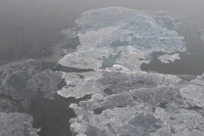
Benz (Thanachart) checking out mostly frozen Turnagain Arm.  It was about 10˚F (-7˚C) that day and while it was mostly clear when we left the house, twenty minutes later it was mostly cloudy in the Arm and soon began to snow lightly.


And there was a brisk wind.  We walked around Beluga Point checking the ice formation on the water.  It was getting really cold with the wind.  So it was a little surprising when we saw three people get out of a car.  She was wearing lots of white. They climbed over the barricade and over the railroad tracks.  She pulled off her shawl and they started taking wedding pictures.  He had on an overcoat and scarf.


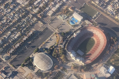
We came into LA, just north of the airport headed east (earlier photo above) came back a bit, and then looped around north with this view of downtown and all the mountain backdrops clearly displayed.  When we completed the circle we were headed west right over the Coliseum.


It was the 1984 Summer Olympics that made me realize what a huge part of my life the LA Coliseum had been.  From Boy Scout jamborees to rodeos,  early Dodger games and UCLA football games - I'd been to the Coliseum for various events all my early life.

Click to see map better

And at the LA Sports arena (the white oval)  I saw Lyndon Johnson nominated to be the vice presidential candidate with John Kennedy in 1960.  Someone had given my mom tickets and we were way up near the rafters, but we were there.  And I watched the UCLA basketball team in 1963 beat number one Michigan there - getting 16 points in a row at the beginning of the game - to go on for their first undefeated season and the beginning of their dynasty.  I also spent a lot of time in the museums and rose garden there at Exposition Park as a kid.  Followed by my graduate studies next door at USC.  Lots of my formative years spent in these few square blocks below us in the airplane yesterday morning.


 After we stopped at Bells Nursery (previous post on Christmas trees) Benz and I drove up to Glen Alps and walked to the Powerline Pass trail.


We're closing in on the airport here.  I'm looking north as LA stretches to the hills.  It stretches even further over the hills in the valley.  And south out the other side of the plane.  And east.  But you can't see it quite this clear most days. 


This part of Chugach State Park is about 20 minutes from downtown Anchorage.  Nothing out there but nature- trees and bushes, a few trails, moose, bear, and other smaller critters. 


Here's Benz, tanning, Anchorage winter style. 


To put the top ice picture into perspective, I thought I better add this one Benz sent me.  All these are sharper if you click them.


Friday, November 29, 2013

From Rainy LA To Sunny Anchorage


Somewhere in Alaska air space, I noticed another plane outside the window.  Actually this photo is blown up a bit so you can see that it's another Alaska Airlines plane below us and to the west.

The pilot had banked to the left, then to the right, and back to the left and then I noticed the plane.  I saw the contrails first, and then the plane.


This is more what it looked like out the window.  It stayed with us a minute or so.  Then we banked again and then the other plane seemed to fall back.


You can see the contrail above our engine and the plane itself is almost in the middle.  Click the picture to see it much clearer. 


Waiting to take off in rainy LA


After a week of sunny warm days in LA, it was raining Friday when we left.  But they need whatever water they can get down there.  Seems we left when it started raining in October too.


Shortly after we had flown alongside the other jet, the clouds started to break up and we had some spectacular sunset views.


Clouds hanging over the water as we're getting near Prince William Sound.  


The setting sun makes big and stark shadows in the water. 

Shooting out of airliner windows offers challenges, like all the spots in the lower left not to mention the smudges that refract the light.  But have to just make do since the picture below is so spectacular.  I've done no photoshop clean up or enhancement  on any of these


Soon we were flying up Cook Inlet.  Here the ice picks up a golden glow from the sun.


We're getting close to the airport.  This is ice on Cook Inlet.


The nicks and scratches and water on the window are much less visible when the sun's not shining directly at you.  More ice patches just before we land.


I stuck this one in to contrast with the view of the airport in LA with the rain drops on the window.  It was 3:20 pm.

People in LA were asking if it's dark all the time now, so I thought it would be good to show that it isn't.  In LA now, the sun was setting around 4:30pm.  I do have to say that it gets light in LA around 6:30am.  In Anchorage on November 29  sunrise was 9:42 am for a total of 6 hours and 12 minutes from sunrise to sunset.  Officially, the sunset was 3:54 pm according to Time and Date. 

And the twilights are much longer this far north.  In LA the sun seemed to drop into the ocean pretty fast and we knew we didn't have much time to bike home before it was dark.  But here, the glow lasts. 

And on a sunny day like Friday, even after the sun is gone in town, it's still up there in the mountains as you can see in this ride home from the airport.  The camera says this was taken at 3:48 pm.


I keep thinking these flight pictures are going to get boring, but each trip the light is different and the views are different.  Saturday is the last LA-Anchorage non-stop flight of the year.  I'm not sure when they start again in 2014.  It sure makes the trip a lot faster.  Today it was 5 hours and 15 minutes.  

Oh, yeah, it's just below 0˚F (-18˚C) here.