Showing posts with label Canada. Show all posts

Tuesday, July 08, 2014

Three Bears, Dandelions, And A Moose

Some leftovers from the drive back to Alaska.


BEAR 1


Just leaving the Cassiar Highway, we saw our first bear.  A black bear.  Who was busy eating dandelions.

It seems when bears come into town, they ignore the dandelions and go after other things.  A shame.


So there's no doubt, here's a picture where he has the dandelions in his mouth.  I'm sure they would have been tastier when they were fresher and hadn't gone to seed yet.


I did stay in the car.  These photos result from a combination of the bear being close to the road, not concerned when I stopped,  my Canon Rebel telephoto lens, and some cropping. 


One more of bear 1, heading off. 


BEAR 2


This black bear was mostly brown and we first saw him sitting in amongst the dandelions. 


His reddish brown fur was a bit mangy. 


BEAR 3

The next day, between Haines Junction and Kluane National Park, we saw the brown bear. 


It too was at the side of the road eating dandelions.  I stopped well before I got to the bear and was able to get a couple of shots when a big pickup pulling a huge trailer passed me slowly and stopped right next to the bear. 

Thanks, I muttered, and thought some choice things about the driver as the bear turned to the brush and disappeared. 


There must have been some discussion in the cab of the truck.  At the visitor center at Kluane National Park the trailer pulled up just after we did and a woman got out and apologized for her husband chasing the bear away.  The husband didn't get out.  I imagine this woman might apologize for her husband a lot.  I told her it was fine, I'd gotten my pictures. 

Then we went for a short hike to the first viewpoint on the nearby trail the rangers suggested. 


Kluane is a huge park and is a World Heritage site  combined with several other US and Canadian parks. 
The Kluane/Wrangell-St. Elias/Glacier Bay/Tatshenshini-Alsek national parks and protected areas along the boundary of Canada and the United States of America are the largest non-polar icefield in the world and contain examples of some of the world’s longest and most spectacular glaciers. Characterized by high mountains, icefields and glaciers, the property transitions from northern interior to coastal biogeoclimatic zones, resulting in high biodiversity with plant and animal communities ranging from marine, coastal forest, montane, sub-alpine and alpine tundra, all in various successional stages.
 It has a tiny, fairly primitive visitors center.  So far, it hasn't been spoiled with an adjoining commercial cluster of hotels and restaurants and other encroachments on the wilderness.  The hike was pretty much straight up, but the view was wonderful, the temperature delightful,  and there were a number of birds and insects (besides mosquitoes).  A visit to this national park is a visit back in time as well as space.  This won't last too much longer I suspect.

Then, driving on, in the 30 mile no-man's land between the Canadian border station and the American border station, we saw this stock image of a moose in a lake in the wilderness.  But I couldn't resist getting a picture.


Sunday, June 29, 2014

Driving Up The Violated Cassiar


Just a quickie from Dease Lake.


We stopped at Kinaskan Lake along the Cassiar Highway yesterday.  The weather was comfortably warm with more blue than clouds.


The sun went down about 10pm.  Here are some pictures of the lake from our campsite.


Late Afternoon


About Sunset

This Morning


It started raining before we got up this morning and this last picture is from the same spot as the previous two.

We first went up the Cassiar in 2000.  It was spectacularly beautiful.  Much of the road was dirt and our car got very muddy.  

Last fall when we drove down, we were startled by huge powerlines going up in the southern part of the road.

This time sickened is more appropriate than startled.  For 400 kilometers they've bulldozed huge areas along the road to put up powerlines.  I need to do more research - I did talk to two locals - but it really looks like this is about mining needs, not local needs.  Very few people live along this highway.  And the ugly, disgusting way they've trashed the landscape is appalling.  I hope to find out more about what this is all about.  This was once an incredibly beautiful landscape.  


This is one picture of the destruction along the once pristine Cassiar Highway.  It's like this for almost 200 miles.

Saturday, June 28, 2014

Canada's New Anti-Spam Law and Supreme Court First Nations Land Claims Decision

Driving back to Alaska means seeing the world through Canadian eyes for several days.  A couple of big stories include a Supreme Court decision in favor of First Nations land rights that seems to have major consequences.  From the CBC:
The Supreme Court decision on Thursday granting the land claim of a B.C. First Nation is not only a game-changer for many aboriginal communities across the country, but also for the government and the resource industries.
The unanimous ruling granted the Tsilhqot’in First Nation title to a 1,700-square-kilometre area of traditional land outside its reserve, marking the end of a decades-long battle.
But it also clarified major issues such as how to prove aboriginal title and when consent is required from aboriginal groups, which will affect negotiations on major projects such as the Northern Gateway pipeline.

And Tuesday, which also happens to be Canada Day, a Canadian anti-spam law takes effect.  From the government's anti-spam legislation website:

When the new law is in force, it will generally prohibit the:
  • sending of commercial electronic messages without the recipient's consent (permission), including messages to email addresses and social networking accounts, and text messages sent to a cell phone;
  • alteration of transmission data in an electronic message which results in the message being delivered to a different destination without express consent;
  • installation of computer programs without the express consent of the owner of the computer system or its agent, such as an authorized employee;
  • use of false or misleading representations online in the promotion of products or services;
  • collection of personal information through accessing a computer system in violation of federal law (e.g. the Criminal Code of Canada); and
  • collection of electronic addresses by the use of computer programs or the use of such addresses, without permission (address harvesting).

Michael Geist at the Toronto Star looks at three issues people have with the new law, and points out that some of their issues suggest they may not be in compliance with a previous anti-spam law.

We're in the Skeena Bakery in New Hazelton.  We watched loons and swallows and redwing blackbirds at Tyhee Lake this morning early.  [Pictures up now here.] On up the Cassiar Highway when we leave here.

Thursday, June 26, 2014

We Should Be Somewhere Between the Canadian Border and Prince George

We leave Seattle shortly.  Our little camper is packed and we're driving it home.  Don't know when we'll get our next internet connection so I'm scheduling this for later today.  It's US -0 and Germany - 0 as I write this. 

Looking forward to a relaxing drive home.  We've got The Luminaries on CD - 30 hours worth - to listen to.  Eleanor Catton's novel won the Man Booker Prize in 2013 which bodes well. 

Friday, December 06, 2013

AIFF 2013: Take A Trip Via Film Part 1 - From Afganistan to Germany

Use the festival to take some short trips to other countries.  

I've gone through the Festival Genius and sorted by country.  It means it was made by someone from that country, it does not necessarily take place in that country, but probably does.

I've linked to the Festival Genius description which also has the times and dates the film will be shown.  Shorts are shown in programs with other shorts.

Have a good trip, or two, or three.

Here's the group:  A-Ma    The rest of the alphabet will be up shortly.


Afghanistan/USA
Fatigued  (short doc)

Antarctica
Antarctica:  A Year on Ice

Australia

The Rose of Turaida (animated super short)

Alaska Sessions:  Surfing The Last Frontier (Doc) 

Suspended (short narrative fiction)

Mine Games (feature)


Canada

Yellow Sticky Notes  Canadian Anijam (animated short)

Tales of the Organ Trade  (doc - I reviewed it here)

“Gaspé Copper” d’Alexis Fortier Gauthier (bandeannonce) (short narrative fiction)

Magnetic Reconnection  (short doc)

Stalled (short narrative fiction) also New Zealand and Switzerland

The Animal Project (feature)

Mourning Has Broken (feature)

Pottery Wars (short doc)

Hasard (short narrative fiction) (also Germany)

Santa's Claw (short narrative fiction)

The Trap (super short narrative fiction)


China
The No Name Painting Association (short doc)
Will You Still Love Me Tomorrow?    (feature)

Denmark
Life (short narrative fiction √)
Fucking Tøs (Damn Girl) (short narrative fiction √)
(Both are in the same program - Reel/Real Life Shorts)


France
Mr. Hublot  (animated short √) (also Luxembourg)
Himalayan Gold Rush (doc √)

Germany
The Fusion (short narrative fiction)
Great (short narrative fiction)
Hasard (short narrative fiction) (also Germany)


Monday, September 23, 2013

Hell's Gate Tram - Hiking Down - Open Coal Trains


"Originally perceived as a major obstacle to travel between the Coast and the Interior, the Canyon over time became the principal route for commercial and passenger traffic.  Originally dangerous in the extreme, travel through the Canyon was always a formidable prospect, although today's vastly-improved modern highway does not hint at the once terrifying and difficult journey that clung to the mountain's walls as if by sheer nerve.  Simon Fraser's journals speak of having to traverse sections of the canyon by a series of precipitous ladders and rock-climbs, and although several generations of road-builders had a crack at it (from 1859 onwards), the route remained a dizzying cliff-hanger until major highway improvements began in the later 1950s."

Before we got out of the canyon, we  stopped at Hell's Gate tram parking lot for lunch.  We made some sandwiches and checked out the tram office.  $21 to ride the tram - 1000 feet down into the gorge and their tourist shops and restaurant.  Not for us.

(I thought I'd written on this before and I do have a post that focuses on how the original work in the canyon resulted in disaster for the salmon and the people who lived off the salmon.)  

Another couple talked to the guy at the tram and when they passed us said there was a trail to the bottom that only took half an hour.

We walked along a path, under the red bridge to the other parking lot and then came to another parking lot.  The trail was wide enough for a vehicle, but gated off.  And it was a beautiful forest.  The sign said 1 km - a little more than half a mile. 

 This mourning cloak butterfly was flying and resting near me so, I thought I should get a picture. 


It was was definitely down hill, but not bad.  At the bottom there were no trespassing signs and danger signs, but I figured if they guy had said you could walk down, I'd do it.


From the bottom, here's one of the trams.  It took about 15 minutes to get down and 20 to get back up.  But you do have to cross the railroad tracks and given the long trains we saw, you could get stuck.  I decided I didn't need the touristy stuff - the tram website says:

Facilities include:  Simon’s Cafe, Gold Panner Gift Shop, Education Centre, Fudge Factory, Gold Panning, Simon’s Wall, Observation Decks & Suspension Bridge.
 I was more interested in the walk and the gorge.  The water must have been low because it wasn't the rushing torrent I was expecting.

Shortly after I got back over the tracks and started my return trip to the highway, this coal train came by.  I was amazed to see the coal transported in open cars.  Was there something I was missing?  I didn't see any coal dust going into the air, but it was a warm, windless day.

So I checked. 


 Coal Train Facts, a website opposed to shipping coal from Montana to Cherry Point in northwest Washington for shipment to China outlines coal dust concerns:

Because most coal trains are uncovered, they produce significant amounts of coal dust in the course of transporting the coal from one place to another. According to BNSF research, 500 pounds to a ton of of coal can escape a single loaded car. Coal dust is regarded as a nuisance, as the dust can damage the ballast and, the railway claims, cause derailments.  BNSF asks that shippers pay for dust mitigation; shippers typically balk at paying. The Puget Sound coast line is notoriously rainy and windy; it is unclear as to how effective surfactants might be at containing the pulverized coal in adverse weather. There seem to be no guarantees that dust would successfully be controlled en route from the mines to the port. 
Dust is also generated at the terminal site, as bulldozers continually shift and rotate the ground-up coal. Constant turnover is required to both keep the coal in one area, and also to prevent spontaneous combustion.  Wind and moisture can agitate the combustive properties of coal. The potential adverse effects of coal dust on adjacent sites was a factor in the Port of Vancouver rejecting a proposal to export coal from a new export site there. The dust is notoriously difficult to control, and has proven to be a concern for residents close to Westshore, the coal port in BC. The coal at the proposed GPT terminal will be stored in open heaps on 80-105 acres located in proximity to the Cherry Point Aquatic Reserve. Cherry Point can be buffeted by high winds, winter conditions often see wind gusts in the 60-70 knot range. It seems likely that the wind will agitate the heaped, pulverized coal. 
The leaching of toxic heavy metals from coal ash into water supplies is a proven problem. Exposure to arsenic, cadmium, barium, chromium, selenium, lead and mercury can cause any number of health problems, including cancers and neurological diseases.  It is unknown if and to what extent these heavy metals might leach out from the coal and/or fugitive coal dust, from the train cars and at the terminal storage site, into local water supplies and into the marine environment. There are potential implications for the safety of the water we drink and the seafood we eat.
- See more at: http://www.coaltrainfacts.org/key-facts#sthash.kjyRH0uH.dpuf
The pro coal side, represented by Freedom Works in this case, tends to pick at the details, but essentially seems to acknowledge the problems - just not where the environmentalists say.  Here's an example (which doesn't refer to the quote above): 
That passage from the white paper is instructive for a couple of other reasons. The author cites derailments and the average amount of dust lost from coal cars, but he does not say WHERE these things occur. It turns out that the two derailments in 2005 happened on the short Powder River Basin line, not far from the train's point of origin. It was attributed to coal dust fouling the ballast used as a bed for the rails. Regarding the amount of coal dust lost, what the enviros never tell you is WHERE that dust is lost. It doesn't take much effort to realize that most of the dust will be lost at the point of origin - near the mine where the cars are loaded. The further the train travels away from the loading point, the more the load will settle, meaning that less dust is going to blow away. The environmental extremist way of explaining this is to say, "It is unclear how much coal dust might escape in the Pacific Northwest ..."

Juan did a much better job of getting pictures of the spot than I did.  Check his site.

Sunday, September 22, 2013

Clinton, BC - 150 Years Old

"Staying true to its rawhide roots today, Clinton’s Main Street still exudes a Wild West flavour, with many of the buildings boasting their original storefronts, restored to retain the western atmosphere and character." [from Visit British Columbia]


Maybe that's what lured us, after getting gas, to just park on the main street - Cariboo Highway - and walk around.  And then pull out my camera.


After the discovery of gold in the Cariboo, Royal Engineers were commissioned to build a road through the Fraser Canyon to the Cariboo to join the already existing wagon road from Lillooet to 47 Mile. The junction was 47 miles from Lillooet and thus 47 Mile was the name used until 1863, when 47 Mile officially became Clinton. The community also boasts of hosting one of British Columbia's oldest continuously running events, the "Clinton Annual Ball," held in May of each year.  [BCAdventure.com]


"Once a busy junction on the wagon road leading to the Cariboo and Barkerville gold fields, Clinton was originally known as The Junction, and Cut Off Valley, before being renamed in 1863, honouring the Colonial Secretary, Henry Pelham Clinton, the 5th Duke of Newcastle." [Visit British Columbia]

The sign in front of this old Church says
"High Bar First Nations."

I looked hard to find more than business info on the High Bar and eventually went back to the Wikipedia entry:


"The High Bar First Nation is a First Nations government of the Secwepemc (Shuswap) Nation, located in the Fraser Canyon-Cariboo region of the Central Interior of the Canadian province of British Columbia. It was created when the government of the then-Colony of British Columbia established an Indian Reserve system in the 1860s. It is one of three Secwepemc bands that is not a member of either the Shuswap Nation Tribal Council or the Northern Shuswap Tribal Council. The High Bar people are also partly Tsilhqot'in and have links with some Chilcotin First Nations.
In the Chilcotin language, the High Bar people are the Llenlleney'ten. The Secwepemc in the Fraser Canyon and on the Chilcotin Plateau are also known as the Canyon Shuswap and have traditionally had close ties with the Tsilhqot'in people."
The High Bar First Nations Facebook page offers a little more information.

This painting on the builiding looks a lot like Southeast Alaska art work.  I don't know the relationship between the High Bar and Tlingit/Haida peoples.  


Our modern world changes how we know and what we can know easily.  Just googling the address I found the listing for this house.  They want $215,000 (that's Canadian, but pretty close to US.)


We also learned about Clinton the old fashioned way.  We talked to Bruce who owns this second hand store.  Even after figuring out we weren't planning on buying anything, he was friendly and talkative.  He was less sanguine about Clinton suggesting it was more like a town in a Stephen King novel and that the Many Good Things sign was an allusion to King. (I couldn't find the book it comes from, but I did learn that a lot of people use the phrase "I've heard many good things" when they post about Stephen King.)  He's also a former figure skating coach and an artist. 


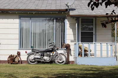
I didn't check online for the price of this motorcycle, but if someone is really interested, email me.  The phone number is legible on the original.


Google came up blank on Mr. and Mrs. Joe Dealz.  I think it's a great title for a book. 


The museum.


I do appreciate people who make the extra effort to do things like design their fence around a rock. 

An historical cairn in Clinton marks the junction of two routes to the Cariboo gold mines; The original 1859 Cariboo Trail from Lillooet, and the Cariboo Road through the Fraser Canyon, built in 1863 by the Royal Engineers.
Situated halfway to these gold fields, Clinton was an ideal place for weary travellers suffering from gold fever to stop for a rest, food, entertainment, and even encouragement. Clinton grew with the demand for these services. [from Visit British Columbia]


I guess this is the 150th Anniversary of this town becoming Clinton.  Travel British Columbia says 793 people live in Clinton.  City Data says 636 in 2011.  They also had a map.   Clinton's the blue spot in the upper right.  Click to make it clearer and bigger.


Saturday, September 21, 2013

Anchorage to Seattle Day 6: Lac La Hache to Bainbridge Island


He was comfortably resting by the porch when I showed up, then ambled up to the picket fence where he just wanted to be petted and get some attention.  This was on the main street of Clinton, BC, which happens to be the highway.  We stopped here for gas and it seemed so much less spoiled by strip malls and chain stores that we walked around.  I'm going to do a whole photo portrait of Clinton.  This is just a preview.


We began after breakfast at the Provincial campground at Lac La Hache.  We're clearly getting into civilizations.  The campground bathrooms had flush toilets and and granite counter tops.

Compared to three years ago, Thursday (Day 5) and Friday (Day 6) went much faster because there was less traffic and almost no interruption due to construction.  And this last day was mostly sunny and warm - about 20˚C I would guess.


The landscape was getting more arid.  We were passing what almost looked like semi-desert, with these bunches of yellow flowers topping gray-green foliage.  I don't know what they are, but they were everywhere. 


And then we got to the Fraser River and Canyon.  We followed this passage for several hours.  The train seemed endless and was there whenever we looked.  One side of the canyon was dry and the other side lush with evergreens. 


At this point we're closer to the water.  We couldn't see the end of the train in either direction. 


And there were lots of tunnels along this route.  Most, so well lit up, I didn't need to take off my sunglasses. 

Along this route we got to Devil's Gate, where we had lunch and took a short hike in the beautiful weather, which I'll do a separate post on. 

Eventually we got out of the canyon and onto a freeway - Canada Highway 1.  At Abbotsford we got off the freeway and headed south a couple of miles to the US border.  I just checked now and found there's a cam at the border you can check online to see how crowded the customs line is. 


Crossing into the US here was easier than when we crossed into Canada in the relatively remote Beaver Creek crossing into the Yukon.  Then we were back on small rural road heading west and then south into Bellingham where we caught the I-5 to Seattle.  It was here, in the middle of five lanes of southbound traffic, as it was getting dark, that it started pouring.  But by the time we got to the ferry terminal, the rain had ended.  Below is a view of some of the Seattle skyline as the ferry took off for Bainbridge Island. 


This is a great road trip and I wish we had more time to poke around, hike, and just enjoy the beautiful country.  Driving through Canada does require us to think differently - the signs are in kilometers and the gas comes in litres.  The dollars are pretty close to equal so that's relatively easy.  It's generally good when the things we take for granted get skewed a bit and we have to think about them and realize our world is not the only possible world.  (Just not too much at once.)


Our grand daughter has grown a lot, is crawling and pulling herself up to a standing position, and picking up bits of food and stuffing them into her mouth.  She's also a lot more cautious about straying far from Mama. 

Friday, September 20, 2013

Anchorage To Seattle Day 5: Hazelton to Lac La Hache


Day 4 got us from the northern end of the Cassiar Highway all the way down to where it connected to the Yellowhead Highway (37).   This is what it looked like Thursday morning.


We'd begun at the Seeley Lake campground which was a lovely spot with nice campsites, but right up against the highway with lots of trucks going by all night.

Seeley Lake


I put up a picture of the Skeena Bakery, a few miles from the campground, at the end of yesterday's post.

Once off the Cassiar, we're out of the wilder country and coming into more civilized territory.  There are still lots of trees, but the forest areas are broken up by lots of small towns and farmland.  We saw lots of timber trucks and here and there stacks of dead trees.


It's hard driving and taking pictures so this isn't too representative of the land we passed through.  We stopped for lunch at Burns Lake.

Burns Lake


Reading the local paper in the New Leaf Cafe, we saw that there's lots of local opposition to the Enbridge pipeline that would take oil to the British Columbia coast.  


Trips like these run well with audio books.  We'd listened to Eowyn Ivey's The Snow Child out of Alaska and into the Yukon and Cassiar.  I hate to be churlish - anyone who actually writes a whole novel has my admiration.  And an Alaskan first novelist who wins international awards is something I want to support.  But I felt somewhat like this commenter at the Guardian:

"The descriptions of landscape are good.
I liked the way the women in the book were described which was not stereotypical.
But the actual story became boring because it was so obvious what was going to happen at each stage. Also the interpretation that wove myth and reality was often clumsy. Needed more hard thought how to make it work. It was a good concept but the author needed a bit of help and editing support."
The blending of supernatural and real is tricky.  And as the next book began - Walter Mosley's The Gift of Fire - I thought I had an example of an experienced writer doing this much better.  And that was true at first.  He didn't fuss trying to explain things - he had confidence that the reader would figure it out.  And it's much, much shorter.  But it too seemed to struggle to hold together what it started.  Both books though had lots of good insights into human beings and how they tick.  And a number of reviewers had much more positive things to say.  For many Alaska was an exotic setting.  For me it was home, though nearly a century ago and in harder times.

I realized yesterday that many readers have no idea where the places I've been writing about on this trip are.  The map below started in The Milepost and I've added white stars to mark Day 4 and bluish ones for Day 5.  Day 4 began about 60 miles south of the junction between the Alaskan Highway (also known as the Alcan) and the Cassiar Highway. Day 5 has us rejoining the red line from the Alcan at Prince George.


I saved it pretty big and if you click on it, you can see it a little better.


We were trying to make it to Lac La Hache to have dinner at the Edelweis restaurant which I've written about in a previous trip.  But when we pulled up at 7:30pm, the closed sign was already up.  But we did have this great sky to console us.  And a full moon came up a little later.  And it felt much warmer than it had been.   

We made it to Seattle this evening and I'll do more on today's trip later.