Showing posts with label mountains. Show all posts

Friday, October 20, 2017

Mario And Marlene After Their 3 Day El Capitan Climb

After watching the slackline walkers at Lost Arrow, we took the shuttle to El Capitan and looked up at the giant rock to look for climbers.  I could only find a couple.  (I did not take my telephoto lens on this trip, so this was the best I could do.)


Let's put this into the context of the whole rock.


I know a lot more now about El Cap (as the rock climbers all called it) than I did when I talked to Mario and Marlene.  I've watched several El Cap climbing videos and realize that where I saw a big rock, the climbers saw various routes and various features that are all named and ranked by difficulty.

At the meadow below El Cap,  I asked this photographer which climbers he was following, he said all of them.

Which leads me to believe, now that I have had  time to poke around online, that he might well be Tom Evans who has a website call Elcapreport.com which I got to because I saw several vehicles with that url on them in Yosemite.  He's got much better shots (yes that telephoto does much better than my camera) there, with a set of photos of climbers on El Cap from this week.


There can't be two photographers who know as much as he did about all the people on the mountain. (Well, sure there can, but I'm betting it's him.) Marlene and Mario (in the video below) are in the background. They had started up the Triple Direct route on Friday and reached the top on Sunday and had just hiked down when I met them.

This is probably a good time to just watch the video.  Remember these two had just spent three days climbing El Cap and a fourth hiking down with heavy packs.  I didn't quite catch what they were saying about their route, but I've looked up the routes on El Cap, and it was clear they were talking about Triple Direct.  So listen for it.


I took this screenshot from Triple Direct El Capitan.


It looks a little different with the shadow, but you can figure it out on my picture above.

We went back to El Cap when we drove home on Tuesday.  Here are some more pictures to help you put this all into some context.  In the one below, you can see some climbers, and you can see what I mean about all the crevasses and other features that, if you take time, you'll get to recognize.


Click on any of these images to enlarge and focus - I saved some in higher res than normal

On Tuesday, I walked through the woods closer to the base.  Here's a sign I passed on the way.
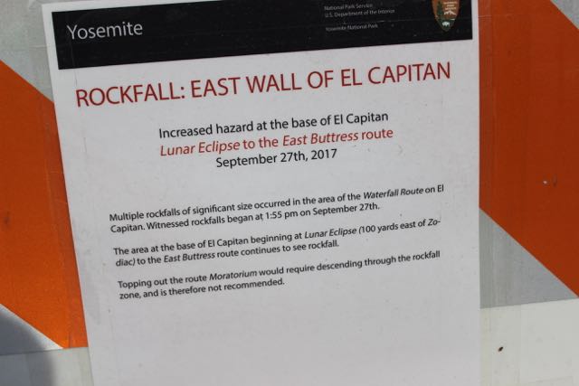


And another:


Here's a look at part of the base from a clearing.


Again, saved this in higher than normal resolution, so click to dramatically enlarge

And here's most of El Cap from below.  The wide angle lens does distort it, but this gives a better sense than the other pictures of how big this mountain (It really seems more like a rock than a mountain) is.  (I googled "Is El Capitan a mountain?"  Wikipedia calls it a "vertical rock formation.")


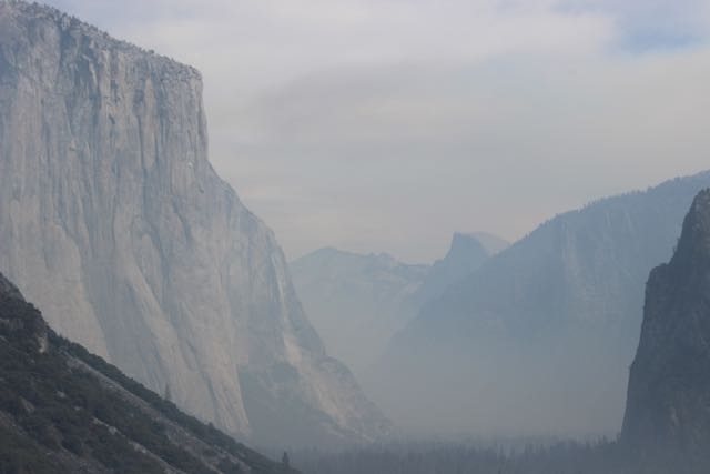
And here you can see El Cap on the left (and Half Dome on the other side of the Valley in the distance) just before we entered the tunnel out of the valley and headed south.  It was still a bit smoky, but not near as bad as when we got there.  


After talking to Marlene and Mario and watching some YouTube videos of people climbing El Cap, I'm more inclined to see these folks as much saner than lots of people think about climbers.  You have to be pretty well organized to undertake an adventure like this.  These people are not, as many of the tourist observers at Yosemite seemed to think, suicidal.  They have lots of equipment to ensure their safety.

Here are two YouTube videos that get you much closer to what it's like to climb El Capitan.
These are two very different stories of climbers on the same mountain.  Both fascinating stories that fill in a lot more than I got this week.


These videos show us how much more we are capable of than most of us think.  But it takes work.


I think I need to check out the rock climbing wall when I get back to Anchorage.


Wednesday, October 18, 2017

My Perfect Yosemite Moment - 8 AM Hike To Mirror Lake

The fantasy spurred this trip to Yosemite was a chance to relive the magic I remember of Yosemite as a kid.  So Monday morning I got up early, caught a shuttle to the Mirror Lake trail, then wandered up the trail, by myself.  Well, just me and my camera.  I paused a bit reading the sign that warned of Mountain Lions and that you shouldn't go alone.

It's such a beautiful trail.  My pictures don't do it justice.  But for an hour or so, I was alone in Yosemite hiking to through the quiet woods to a spot I remember vividly as a little kid.  There were warnings that by October the lake is really mostly sandy beach, but I was willing to try to find some reflection in Mirror Lake.

Here's a bit of the trail that goes through different kinds of terrain.


It's about a mile hike from where the shuttle bus lets you off.  And relatively flat.  Not like the Vernal Falls hike.


Later I thought about all the huge boulders everywhere and how it's clear that they come from the walls of granite that surround you everywhere in Yosemite.  They most come down sometime.  Fortunately, not while I was there.


And everywhere you are, if you look up, you see those massive chunks of granite towering above you. The wide angle lens takes away the closeness and sheer size of rock, but the regular lens can't catch the whole rock.


I didn't see any mountain lions, but I did see a huge pile of pretty fresh bear poo.  I'll spare you the picture, but I did check with a ranger because it was very different from the bear scat I'm used to in Alaska.


And there was enough water to get a good mirror image of the mountains of  rock above.


It was still very smoky from the Northern California fires.  Our car had ash on it each morning.


With the low water level revealing the sand, it looked a lot like a Zen garden.


And here's one of those walls above Mirror Lake.


It was a magical hike.  All alone on this beautiful trail.  I didn't see anyone until after I'd been at the lake about 20 minutes.  It was what I went to Yosemite for and was wonderful.

Monday, October 16, 2017

Lost Arrow And Other Fun In Yosemite Today [UPDATED With YouTube Video]

I have so many pictures of so many things, but I want to give you a preview here.


Here's how we first saw the Lost Arrow, though we didn't know what it was called at the time.  A man was looking through a humungus telephoto lens up at this jutting rock high above us.  Here's the start of the legend of the Lost Arrow from the Yosemite library website.

"Tee-hee-neh, a beautiful Indian maid, was betrothed to Kos-soo-kah, a young brave, who was fearless and bold with his spear and bow. At dawn on the day before their marriage, Kos-soo-kah made ready with other strong braves to go forth into the mountains to hunt bear, deer, rabbit and grouse for the wedding feast. Before leaving, he slipped away from the other hunters to meet Tee-hee-neh, his bride, who was waiting nearby.As they parted Kos-soo-kah said, “We go to hunt now, but at the end of the day, I will shoot an arrow from the cliff between Cho-look, the high fall, and Le-hamite, the Canyon of the Arrow-wood, and by the number of feathers you will know what kill has been made.”  [There's an editor's note that says this legend may be fictitious.  I guess that refers to the fact of it being a legend, not the story itself.]
The rest is here, along with other Yosemite legends.


Our second view of the Lost Arrow was from the Lower Yosemite Falls view point where you get a better sense of where it is.  Here's some more history of it from a climbing website, SummitPost.
"There aren't many climbs in Yosemite that lead to a true summit. But of those that do, the Lost Arrow Spire has to be one of the most famous and exciting of all. The Lost Arrow Tip was first climbed in 1946 by a party that used some rope tricks to rig up a tyrolean traverse, a popular way to end the climb today. The first actual climb to the top was accomplished by Yosemite pioneer John Salathe and Anton Nelson in 1946. They climbed the Lost Arrow via the Lost Arrow Chimney ( V, 5.10a ), the first grade V big wall done in the U. S. Today the Lost Arrow Tip and tyrolean traverse return are one of the classic climbs of Yosemite!"


It's at 6912 feet.  And all that is leading to the fact that the man with the big telephoto lens pointed out that there were ropes from the Lost Arrow to the rock to the right and someone was crossing it.  I didn't have my telephoto with me, but in this shot below, you can see the rope and the black silhouette of the climber to the right of the Arrow.  The black spot on the left seems to be, well, a spot.  

click image to enlarge and focus a little bit
This led us to wander further down the valley to see if we could see the "dozens" (we were told) climbers on El Capitan.  That's for another post.


[UPDATE 10/18/17:  When I uploaded a video with two El Capitan climbers, my video got posted with a bunch of El Capitan videos.  Which made me realize I should find a Lost Arrow video there too.  There are a number (obviously since people doing this want to document their feats!)  So here's one from Agustín Copp showing this traverse.


And here's Andy the Slackliner crossing.


Friday, June 16, 2017

It's Summer, A Beautiful Day, So Biked The Bird To Gird Trail And Left My Computer Behind

When they rerouted the Seward Highway many years ago from the perilous two-lane, no shoulder road that went well above the water below to a four lane road at the water's edge, the old road was revisioned into a bike trail.  And it's a wonderful six mile ride from Bird Point to the Girdwood turnoff.

The first two or so miles from Bird Point go up with great views of Turnagain Arm.  Though a number of the view points - including telescope-viewers - have cottonwood and other trees blocking the views now.  But not at this point.


Here's the rock wall on the other side of the trail.  There are lots of waterfalls along the way and I counted 18 piles of bear scat on the trail.  Later at the National Forest visitor center near the end of the trail, the lady said that yesterday one of the workers encountered a black bear.  Someone coming the other way had to zap it with bear spray before it left the trail.


Here's the trail on the way down near the Girdwood end.


And back down to road level, there's duck playground.  She wasn't happy that I stopped and hustled her brood off while I got the camera out of the backpack.    It should be a little sharper if you click on it.

Here's a July view from 2011 when the flowers were all blooming and a September view from last year.  Same trail different moods.


Sunday, June 11, 2017

Why I Live Here: Power Line Pass Is 20 Minutes From Home


We needed to get some fresh air and the nearest spectacular spot is Powerline Pass.  Here are a few more photos.


  The grass is about 30 inches high.


I think these are thimble berries flowers.


And tiny cones on the hemlock trees.  One sign of global warming is how high the hemlocks on the trail near the parking lot have grown.  When we came almost 40 years ago, they were severely stunted at this altitude (about 2200 feet), but they've grown considerably higher since we got here.  They were (for those of you thinking, 'well trees grow') already old trees when we got here.


The Glen Alps parking lot is also the starting point to Flattop, generally known as the most climbed mountain in Alaska.  It's 3,510 feet high, 1280 feet above the parking lot.

We chose walk a more level path to Powerline Pass.

Thursday, January 19, 2017

Quick Turnaround

We only got back to Anchorage last Thursday night and already Tuesday we were looking at the Chugach Range from above again.


We're in Seattle at the request of a certain four year old who wanted us at her birthday party.


So we'll stay a while and give her mom some relief.  A win-win situation.  Besides, the temperatures in Anchorage have dropped below zero.

Wednesday, December 14, 2016

The Alaska/Virgin Marriage Begins

Today is the official first day of the Alaska Airlines/Virgin merger. I know that because the flight attendants passed out free chocolates to all passengers on our flight.


They may be officially married, but it sounds like they're not going to move in together though.  The LA Times reports that the two airlines will continue to operate separately for the time being, but starting Monday people can buy Virgin tickets at the Alaska Airlines website.  It doesn't say whether you can buy Alaska tickets on the Virgin website.

It also says this makes Alaska/Virgin the fifth largest US airline, but it's still relatively small:
"Combined, Alaska and Virgin America control about 6% of the nation’s domestic flights. The country’s four bigger carriers — American, United, Delta and Southwest — control more than 80% of domestic flights."

As usual, the flight out of Anchorage offered amazing views. Here’s a view of the ice in the inlet as we took off about noon today.

it gets a little bigger and sharper if you click on it

I was sitting over the wing, so my camera view is a bit obstructed. Denali was hidden by the wing tip for a long time, and then finally came into view before we began flying over the Chugach.  It's about 265 miles by car from Anchorage to Denali National Park, but as the raven flies, it's more like 140.


It was snowing in Portland and the new plane had to be de-iced before we could leave.


Saturday, December 03, 2016

AIFF2016: Full House For Opening Night North American Premiere of Sugar Mountain

Blackwater Railroad Company
Seats were getting scarce 40 minutes before things were schedule to start.  Anchorage International Film Festival director Rebecca Pottebaum enthusiastically welcomed everyone to the festival, thanked all the sponsors, and introduced the Seward based Alaska band Blackwater Railroad Company, whose music is in the film.

I'd note that another Alaskan - Portugal the Man - came up on one of the characters iPod in the movie as well.

Shot in and around Seward, Sugar Mountain was a respectable and interesting film, with very recognizable scenery for most of the audience.  I was impressed that it was made, in part, when there was snow and ice on the ground.  The main characters, facing debt and the loss of their boat, concoct a plot to have one of them get lost in the mountains and then sell their story to the media when he's found.  Things don't go quite as planned but the dig at the media's willingness to pay for such stories is clear.  The acting was good, the story had twists and turns and surprises.  The scenery was spectacular, but the grittiness of Alaska winter also comes through.

Two of the actors - Drew Roy and Haley Webb - were there to answer questions after the movie.  They talked about coming to Alaska (which they loved) to meet co-stars they didn't know, and their relief to find each other to be serious and talented actors.  Haley agreed with a questioner that her character was the antagonist - like a submarine, below the surface, but powerful in directing things.

The film opens in theaters next week, Dec. 9.

After the Q&A, there was champagne and dessert and a time to meet and talk with folks.  I got to talk to some of the programmers for features, documentaries, and shorts.  I asked the features guys for tips on movies that didn't get into competition, but were must sees.  Some suggestions:  Money, The 6th Friend, The Holly Kane Experiment, and Hunky Dory.  I also was assured the film I've been excited about from the descriptions I found on line - Planet Ottakring (Saturday at 3:15) - is a good one.  And, my assumption that Demimonde, the film by Atilla Szász who directed the festival's 2014 Best Feature, The Ambassador To Bern, is spectacular was confirmed.  It plays Saturday at 8pm at the Bear Tooth.

Alex Myung


Among the people I got to talk to was Alex Myung, whose animated film Arrival plays Tuesday night along with the feature Gayla film Real Boy.


Shot from Alex Myung's Arrival


Wednesday, November 16, 2016

Forms of Water: Ice, Snow, Clouds, Water

Flying out of Anchorage always offers amazing views of nature.  As we headed south to gather we family over Thanksgiving, I took advantage of my window seat.  Clouds played a big role in the dramatic landscapes today.  But when I thought about the post, it came to me it's mostly about different forms of water - ice, snow, clouds, and liquid water itself.


The tide was low so we could see the rivers in the mudflats white with ice.


There were low clouds over Prince William Sound and they flowed into the lower levels of the Chugach mountains offering contrasts of the white of the snow and ice to the white of the clouds.


At this part of Western Prince William Sound, the water is blanketed with clouds.


But then there was a spot where the land blocked the clouds and in Eastern Prince William Sound there was water.  At this point in the year, the sun stays fairly low on the southern horizon all day and it will get a little lower yet by solstice.  So at 11am or so it looked like a sunset picture.


Then we got these great cloudscapes.  Large clouds rising in colonies from the water.  It reminded me of the dramatic clouds of Southeast Asia, though these clouds were small in comparison.


My son gave me a book on clouds for my birthday and I was reading through it the other day and thinking I should bring it along.  In the end I put it off for when I have more time and fewer books already on the todo list.  But the clouds today made me question that decision.


The water surface was covered with interesting patterns.  It looked, from 34,000 feet like neat patterns on a flat surface.  But I'm guessing if I could seem them from the plane, the water was probably fairly choppy


And it was still spectacular as we cross out of Canadian air space into Washington State.


Leaving as frequently as we have the last couple of years - first with my mother and then with the grandkids - means constantly cleaning up the house so it's presentable before the housesitter arrives.